 |
Rainbow Bridge
Utah |
|
|
Rainbow Bridge
Utah |
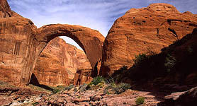
| In the American Southwest, you
will find a concentration of sandstone formations that are called arches,
windows or bridges. The designation depends on their method of formation.
Millions of words have been written about the geology of the American Southwest,
so I wont delve into that too much here. Put simply, water erodes the
6 ancient sandstone layers differentially, forming winding waterways that
get deeper with time. In between each waterway segment there develops,
by default, an increasingly tall ridge that gets narrower as the water
cuts a deeper draw. The outer layer of a sandstone fin is often the
strongest, and the inner section of the fin sometimes simply drops away,
creating an arch. Sometimes, quirks of wind dynamics cause a hole to be
sand-blasted into a fin, creating a window. Other times, a creek
will simply wear away at a spot on the base of a fin until it breaks through,
creating a bridge (since it spans water). In all cases, an initially small
opening is then worn wider and wider with time and smooths out to form
delicate and graceful shapes and curves. Rainbow Bridge spans Bridge Creek,
and is the largest natural bridge in the world, with a maximum height from
creek bed to the highest point of the arch of 291 feet, and a maximum inner
width of 275 feet (Hassell, 1999). The height is only 3 yards shy
of a football field. The creek bed under the bridge is at 3654
ft, and the full level of Lake Powell, into which Bridge Creek now flows,
is 3700 ft. This means that under full conditions, some of the bridges
natural height is obscured by the waters of Lake Powell.
Quick Trip Directions From Page, take State Route 98 east about 50 miles, then head north on Navajo Mt Road (Route 16), which is well marked. After about 20 miles, the road turns into a hard packed dirt road. A fork in the road at around 30 miles is labeled by an old sign that says Navajo Mt Trading Post. Take the left fork. In about 4 miles, youll come to a 50-60 ft sandstone knob on the right of the road called Haystack Rock. Shortly before that knob there is a fork in the road and you should take the right fork which then runs between Navajo Mt and Haystack Rock. If you miss it, just take the next right turn after the knob and it will lead to the same place: a small clearing with a well that is called War God Springs. This is as far as a low clearance vehicle can comfortably go. About 1 mile up the dirt road to the NW lay the ruins of Rainbow Lodge and the head of the south trail. The dirt road narrows and becomes the trail, which is very well marked the entire way. There is also a north trail from Navajo Mt Trading Post, but I dont know much about it. The hiking distance is 13 miles from Rainbow Lodge to Rainbow Bridge (as listed in trail guides I didnt measure), with very dramatic ascents and descents through rugged canyon country. The trail initially climbs steadily up a root of Navajo Mt, splits and then rejoins a ½ mile later, then drops sharply down to 5920 feet in Horse Canyon, only to ascend steeply through switchbacks up the next ridge to the north. From there, the trail heads north uphill for a long time, and one rises up to a maximum elevation of 6440 feet before topping Yabut Pass into Cliff Canyon. A long western-facing downhill trek takes you almost 2000 feet down to the bed of Cliff Creek, where the sheer sandstone cliffs to the south rise over 2000 feet above, providing the first shade of the hike. The trail follows Cliff Creek to the NW for about 2.5 miles, and in April of 2003 numerous clear pools of water and sections of vigorously flowing water were present. The elevation gradually decreases along the way to about 4200 feet before the trail takes an abrupt right turn at Redbud Pass and climbs out of Cliff Canyon to the north and drops down into Redbud Creek. Redbud Pass is a very narrow and steep route that rises perhaps 300-400 feet. Traveling from Cliff Canyon to Redbud Creek via the pass looks easier than going the other direction, due to steep dropoffs on the northern side. Less than a mile after meeting Redbud Creek, the trail intersects Bridge Canyon, along with the northerly route from Navajo Mt Trading Post. From there, the trail continues on only a couple more miles before entering the monument. Rainbow Bridge is a very short stroll from the SE monument boundary. Taking time to explore a couple of side canyons, and stopping often for photographs, we made the hike from Rainbow Lodge to Rainbow Bridge in two days, hiking about 5 hours/day. |
Page Created November 2003