| Monday April 21
 Dawn
broke on John Muirs birthday. Our friend, Matt Perry, also had his birthday
on this day. Endeavoring to reach Rainbow Bridge before the first morning
sunlight touched it, as well as accommodate Daves request that we not
skip breakfast, I set my alarm (GASP!) for 5:30 so that we could also break
camp and filter water before heading out. We both sprung up as soon as
the alarm beeped, and quickly went to work in the cool morning air cooking
breakfast, taking down the tent and shoving sleeping bags into stuff sacks.
I filtered some water, the pump becoming very difficult to operate after
processing some particularly sandy water in Cliff Creek, and we were off.
The night had toughened the tender skin over my blisters, and my feet felt
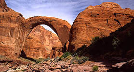
great as we tromped up the sandy trail. At first sight of the bridge, just
prior to reaching Echo Camp, I stopped and photographed the bridge, standing
in morning shadow with the tips of the west-facing walls above brilliantly
glowing dark orange in the morning sunlight. From the distance of ½
mile, it looks tiny and delicate. There is nothing around the bridge to
give it realistic scale in a photograph. We continued on, and stopped now
and again to admire the bridge from different viewpoints. We reached a
point on the trail about 200 yards from the bridge, and set our packs down.
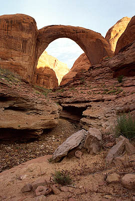
It was not yet 7:00, and the bridge was still in shadow. We clambered down
the steep, ledgy slope towards Bridge Creek, careful of the few delicate
plants somehow surviving in a sea of rock, and I set up my camera on a
ledge just 20 feet above the creek bed, and waited for the sun to reveal
the colors of the sandstone that comprised the bridge. I could have gone
lower in the creek bed, but to do so would have allowed the subsequent
curves in the creek channel to block out the view almost completely. I
reflected that I sat well below the high water line of Lake Powell, and
that three years ago, this photograph would not be possible. As we waited,
I dried out my boots and we enjoyed the morning stillness of this canyon
within a canyon. A profuse hanging garden had taken hold under an overhang
on the opposite bank, fed by another sourceless seep. Up canyon, an entire
slope was covered with small white oaks, each leaf bright green and deeply
lobed. Dawn
broke on John Muirs birthday. Our friend, Matt Perry, also had his birthday
on this day. Endeavoring to reach Rainbow Bridge before the first morning
sunlight touched it, as well as accommodate Daves request that we not
skip breakfast, I set my alarm (GASP!) for 5:30 so that we could also break
camp and filter water before heading out. We both sprung up as soon as
the alarm beeped, and quickly went to work in the cool morning air cooking
breakfast, taking down the tent and shoving sleeping bags into stuff sacks.
I filtered some water, the pump becoming very difficult to operate after
processing some particularly sandy water in Cliff Creek, and we were off.
The night had toughened the tender skin over my blisters, and my feet felt
great as we tromped up the sandy trail. At first sight of the bridge, just
prior to reaching Echo Camp, I stopped and photographed the bridge, standing
in morning shadow with the tips of the west-facing walls above brilliantly
glowing dark orange in the morning sunlight. From the distance of ½
mile, it looks tiny and delicate. There is nothing around the bridge to
give it realistic scale in a photograph. We continued on, and stopped now
and again to admire the bridge from different viewpoints. We reached a
point on the trail about 200 yards from the bridge, and set our packs down.
It was not yet 7:00, and the bridge was still in shadow. We clambered down
the steep, ledgy slope towards Bridge Creek, careful of the few delicate
plants somehow surviving in a sea of rock, and I set up my camera on a
ledge just 20 feet above the creek bed, and waited for the sun to reveal
the colors of the sandstone that comprised the bridge. I could have gone
lower in the creek bed, but to do so would have allowed the subsequent
curves in the creek channel to block out the view almost completely. I
reflected that I sat well below the high water line of Lake Powell, and
that three years ago, this photograph would not be possible. As we waited,
I dried out my boots and we enjoyed the morning stillness of this canyon
within a canyon. A profuse hanging garden had taken hold under an overhang
on the opposite bank, fed by another sourceless seep. Up canyon, an entire
slope was covered with small white oaks, each leaf bright green and deeply
lobed.
The sun hit the bridge, and cast a
thin arc shadow on the western canyon wall. I took a few photos, then we
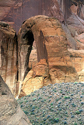
decided to hike up higher and see if we could view it from above somewhere.
There are two sandstone knobs on the east side of the creek bed, just upstream
from the bridge. We walked around both, but found them too steep to climb.
Dave attempted to scale one, but got up about 20 feet and changed his mind.
Instead, we contented with trekking around the flat flower-covered plain
directly beside the arch, so that in places it appeared as a single columner
monolith. During this time, the sun was obscured by growing high cloud
cover in the east, and the colors grew muted and grey. We made our way
down and back to our packs, and played a few hands of Schnitzel, a game
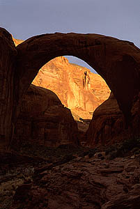
that is only really fun when gambling money. As we waited, the sun gradually
outpaced the clouds, and soon shadows fell to the ground once again. This
was around 10:00. I took lots of photos in the perfect light, and scrambled
down into the very bottom of Bridge Creek further downstream to take almost
vertical shots of the bridge from the spot of a small waterfall on the
south side of the streambed. Its a good thing I have a very wide angle
lens.
Near 11:00, we shouldered our gear
and walked around to the opposite side of the bridge, to where we found
a completely deserted park service viewing area. A stiff breeze picked
up while we waited beneath a log shelter, and the sun dipped in and out
of clouds. We debated where the photographer was when he took the aerial
view of Rainbow Bridge that graces the cover of the book I bought on the
subject, as well as many NPS 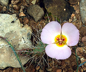 signs.
There are two high vantage points from the SW, both seem very difficult,
if not impossible, to achieve from the creek bed. I certainly wasnt going
to attempt it. I had read that there were some peck holes to the
top of the lower point, a sandstone knob rising about 200 feet from the
top of the creek channel, but I couldnt see them. signs.
There are two high vantage points from the SW, both seem very difficult,
if not impossible, to achieve from the creek bed. I certainly wasnt going
to attempt it. I had read that there were some peck holes to the
top of the lower point, a sandstone knob rising about 200 feet from the
top of the creek channel, but I couldnt see them.
By 11:00, the sky was almost completely
clouded over, and the wind grew chilly. We expected to see the boat passengers
rounding the corner any minute, but none came. We were a bit nervous that
no boat would show this morning, owing to too few passengers. We decided
to walk toward the dock, in hopes of seeing any passing boat. As we walked
towards the dock at 11:15 or so, we saw the fist wave of passengers rounding
the bend. Counting 7 in the first group, we felt confident that this was
the tour boat group. As we passed them, we must have created a little confusion,
since there were no other boats at the dock and we were clearly far from
any roads or resorts. Some people stopped to talk briefly with us, others
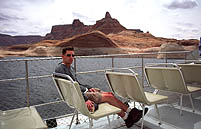
just said hi. We reached the dock, and Doug was on the boat by himself.
He invited us on board, and we stowed our packs in the cargo area up front,
and spent 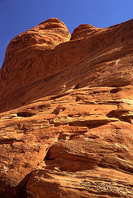 15
minutes chatting with Doug about boating, Lake Powell, points of interest
in the area and other such things that one might guess to discuss with
a tour boat operator. He showed Dave points on the map where the boat now
had to make detours due to the low water level, and explained how the longer
route took significantly more time to complete. After visiting the floating
restroom attached to the dock (complete with flush toilets) and staking
out seats on the top of the deck in the open air, the boat pulled out and
began cruising back to Wahweap Marina under a grey, featureless sky. Lots
of people sat up top with us, and Dave and I were both glad to be in the
open air to vent our powerful BO. Natural musk. I was so greasy I could
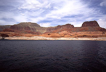
shape my hair like clay. The boat wove through Bridge Canyon and met up
with Forbidden Canyon. The canyon walls were completely barren of all green
plants, and only a couple of birds were sighted the entire time, some unknown
type looking like black sand pipers. The operator narrated the scenery
as we cruised along and pointed out features that looked like fish, hearts
or other animals in the walls. Numerous side canyons rose up and back,
and many twisted out of view, providing a delicious mystery, and thoughts
of a hidden oasis in the rocks. Forbidding Canyon fed into the main channel
of Glen Canyon, and the lake grew to its full dimension, now to be seen
in larger chunks at a time. The sky was grey, and as the boat sped up,
the wind made it downright cold up top. I put on my windbreaker and took
off my hat so it wouldnt blow off. Most others simply went downstairs
to enjoy the safety of the tinted glass windows. 15
minutes chatting with Doug about boating, Lake Powell, points of interest
in the area and other such things that one might guess to discuss with
a tour boat operator. He showed Dave points on the map where the boat now
had to make detours due to the low water level, and explained how the longer
route took significantly more time to complete. After visiting the floating
restroom attached to the dock (complete with flush toilets) and staking
out seats on the top of the deck in the open air, the boat pulled out and
began cruising back to Wahweap Marina under a grey, featureless sky. Lots
of people sat up top with us, and Dave and I were both glad to be in the
open air to vent our powerful BO. Natural musk. I was so greasy I could
shape my hair like clay. The boat wove through Bridge Canyon and met up
with Forbidden Canyon. The canyon walls were completely barren of all green
plants, and only a couple of birds were sighted the entire time, some unknown
type looking like black sand pipers. The operator narrated the scenery
as we cruised along and pointed out features that looked like fish, hearts
or other animals in the walls. Numerous side canyons rose up and back,
and many twisted out of view, providing a delicious mystery, and thoughts
of a hidden oasis in the rocks. Forbidding Canyon fed into the main channel
of Glen Canyon, and the lake grew to its full dimension, now to be seen
in larger chunks at a time. The sky was grey, and as the boat sped up,
the wind made it downright cold up top. I put on my windbreaker and took
off my hat so it wouldnt blow off. Most others simply went downstairs
to enjoy the safety of the tinted glass windows.
We cruised along the black water under
the grey sky, and I reflected on the barren, uninviting look of the rock-lined
lake relative to the lush green canyon bottoms we had hiked in through.
I felt a little sorry for those who only saw Rainbow Bridge by boat, since
everything downstream of the bridge is really nothing compared to the natural
beauty of the upstream canyons. Shortly past Forbidding Canyon we passed
Cathedral Canyon, one of the few side canyons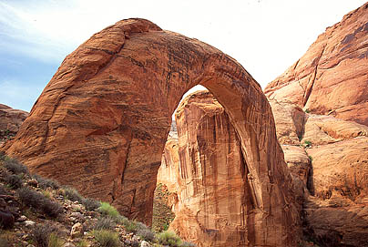 heavily photographed before the dam. The image of that pristine canyon
is so much more inviting than the lake we now floated on. The reservoir
looks very unnatural, as if only flood water drowning out a town, with
only the rooftops visible. I tried to imagine the look of the canyon as
it used to be by stretching the above-water rock lines and angles downward
to a narrow, twisting canyon, but could not. The miles of water inhibited
any vision of a deep, desert canyon. The best I could do was envision Lodore
Canyon far to the north, another coveted monument canyon that was successfully
defended by conservationists from the Bureau of Wrecklamations dam plans.
This trip was about more than seeing a chunk of rock. It was about visiting
a place of unparalleled natural beauty that has been the focus of bitter
political debate, court battles and numerous books. Glen Canyon dam and
the controversies it has ignited will be around for generations, and will
always be a hot topic in the American Southwest.
heavily photographed before the dam. The image of that pristine canyon
is so much more inviting than the lake we now floated on. The reservoir
looks very unnatural, as if only flood water drowning out a town, with
only the rooftops visible. I tried to imagine the look of the canyon as
it used to be by stretching the above-water rock lines and angles downward
to a narrow, twisting canyon, but could not. The miles of water inhibited
any vision of a deep, desert canyon. The best I could do was envision Lodore
Canyon far to the north, another coveted monument canyon that was successfully
defended by conservationists from the Bureau of Wrecklamations dam plans.
This trip was about more than seeing a chunk of rock. It was about visiting
a place of unparalleled natural beauty that has been the focus of bitter
political debate, court battles and numerous books. Glen Canyon dam and
the controversies it has ignited will be around for generations, and will
always be a hot topic in the American Southwest.
"It is the intention of the Congress
that no dam or reservoir constructed under the authorization of this chapter
shall be within any national park or monument." -Section 3 of the Colorado
River Storage Project Act of 1956. It fell to the Secretary of the Interior
to make sure waters of Lake Powell did not enter Rainbow Bridge National
Monument. Hassell (1999) gives an excellent account of the politics involved
in the dam construction and Rainbow Bridge preservation in his book entitled
simply, Rainbow Bridge. The gist of the matter is that a dam was proposed
to keep water OUT of Forbidden Canyon (downstream from Bridge Canyon),
and a second pair with a diversion tunnel proposed at the mouth and head
of Bridge Canyon to keep water out from both sides (to avoid silting behind
the lower dam from Bridge Creek). Both dam projects would have rivaled
Glen Canyon Dam itself in size and 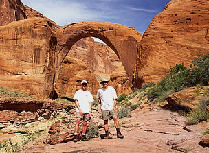 destructive
effect. Both ideas were scrapped due to logistical difficulties. Later,
several separate lawsuits were brought against the Bureau of Reclamation
in an attempt to enforce Section 3 of the CRSPA. These failed, but were
appealed all the way up to the Supreme Court, which declined to hear the
case. At issue was the right of the Bureau of Reclamation to permanantly
alter a national park through its actions. In the end, economics won, and
the electricity and money generated by having Lake Powell at full pool
was favored over an intact, pristine Rainbow Bridge National Monument.
The law has not changed, and even still that law is being violated daily
by the presence of Lake Powell water inside Rainbow Bridge National Monument.
Some geologists have argued that water to the depth of 50 feet under Rainbow
Bridge will inundate the underlying Kayenta sandstone and cause slippage
of the Rainbow Bridge foundation, resulting in collapse. Untold thousands
of dollars were spent in the 70s and 80s in monitoring the bridge, and
the Burea of Reclamation determined there was no danger, so all monitoring
has ceased. Fears have not been completely alleviated, however, and some
geologists still warn that a slip of only a millimeter in the bridge foundation
will bring it down. During this entire time, stretching back almost 50
years, the Park Service has never taken a stand in protection of Rainbow
Bridge, and has instead quietly accepted the proclamations of the Interior
Secretary. The precedent of economics over preservation was set, and continues
unabated to this day; glaringly so under the Bush administration. destructive
effect. Both ideas were scrapped due to logistical difficulties. Later,
several separate lawsuits were brought against the Bureau of Reclamation
in an attempt to enforce Section 3 of the CRSPA. These failed, but were
appealed all the way up to the Supreme Court, which declined to hear the
case. At issue was the right of the Bureau of Reclamation to permanantly
alter a national park through its actions. In the end, economics won, and
the electricity and money generated by having Lake Powell at full pool
was favored over an intact, pristine Rainbow Bridge National Monument.
The law has not changed, and even still that law is being violated daily
by the presence of Lake Powell water inside Rainbow Bridge National Monument.
Some geologists have argued that water to the depth of 50 feet under Rainbow
Bridge will inundate the underlying Kayenta sandstone and cause slippage
of the Rainbow Bridge foundation, resulting in collapse. Untold thousands
of dollars were spent in the 70s and 80s in monitoring the bridge, and
the Burea of Reclamation determined there was no danger, so all monitoring
has ceased. Fears have not been completely alleviated, however, and some
geologists still warn that a slip of only a millimeter in the bridge foundation
will bring it down. During this entire time, stretching back almost 50
years, the Park Service has never taken a stand in protection of Rainbow
Bridge, and has instead quietly accepted the proclamations of the Interior
Secretary. The precedent of economics over preservation was set, and continues
unabated to this day; glaringly so under the Bush administration.
 The
boat ride took 2.5 hours, during which the scenery became monotonous, not
helped by the color-muting cloud cover and whipping wind that drew white
caps on the lake. I dozed off several times, lulled to sleep by the drone
of the boats motor. We drew into Wahweap Marina around 3, trolling slowly
by a houseboat parking lot containing about 8,000 pontoon RVs. Half a mile
north there lay stretched out hundreds of houseboats parked helter skelter
on the water, some no more than 15 feet apart. I guess it must be great
fun to go down to the lake, hop in your houseboat, burn 5 gallons per mile
to drive the houseboat ½ mile away and park it for a week next to
hundreds of others. Actually, it sounds like Hell. The boat pulled into
a courtesy dock and we waited for everyone to leave the boat before going
down and getting our packs. A group of solicitors accosted the folks
in front of us with sales pitches of key rings and refrigerator magnets
bearing images of Rainbow Bridge. For some reason nobody looked twice at
us. I guess our smell kept them at bay. Have to remember that tactic. The
boat ride took 2.5 hours, during which the scenery became monotonous, not
helped by the color-muting cloud cover and whipping wind that drew white
caps on the lake. I dozed off several times, lulled to sleep by the drone
of the boats motor. We drew into Wahweap Marina around 3, trolling slowly
by a houseboat parking lot containing about 8,000 pontoon RVs. Half a mile
north there lay stretched out hundreds of houseboats parked helter skelter
on the water, some no more than 15 feet apart. I guess it must be great
fun to go down to the lake, hop in your houseboat, burn 5 gallons per mile
to drive the houseboat ½ mile away and park it for a week next to
hundreds of others. Actually, it sounds like Hell. The boat pulled into
a courtesy dock and we waited for everyone to leave the boat before going
down and getting our packs. A group of solicitors accosted the folks
in front of us with sales pitches of key rings and refrigerator magnets
bearing images of Rainbow Bridge. For some reason nobody looked twice at
us. I guess our smell kept them at bay. Have to remember that tactic.
| Up a hill and to the parking lot
we hiked, our boots tramping over bright green bluegrass where just hours
ago they had tramped over sand and rocks. We found, pleasantly, that my
car was just where Id left it, and we loaded up in a flash and were off.
We halted at the Burger King for a greasy, quick lunch, then motored on
east toward Mexican Hat. I had hoped to see Monument Valley as we drove
north on 163, but apparently all those scenes you see from movies arent
on that road. We reached Mexican Hat around 6, and drove a short while
further before exiting the highway onto a dirt road, then taking a side
road off that and pulling the car over next to a dry creek bed with three
squat cottonwoods. The terrain was good, barren desert, with sick-looking
Ephedra bushes and scattered dwarf primrose in bloom. The cottonwoods
had small, new leaves on them. Under a dark, cloudy sky, we set up the
tent, and went to sleep, although with difficulty due to the heat and the
greasy, havent-showered-in-4-days feel. |
 |
|