| Saturday, April 19
 The
next morning we got up at 6, Arizona time (7 MDT) and quickly packed up
camp and left. We parked at the Wahweap Lodge and began methodically filling
up our packs with backcountry essentials for the next three days: moisture-wicking
socks, sun screen, water bottles, jerky, squeeze cheese, etc. Soon the
packs were full and we were ready to go. Our plan was to hire a shuttle
to ferry us by van to the old Rainbow Lodge on the south side of Navajo
Mt, hike for three days to and around Rainbow Bridge, camp anywhere we
liked, then take one of the twice-daily tour boats from Rainbow Bridge
back to Wahweap Lodge. When we returned to the marina, we would simply
hop in the car and drive off. All nice and neat. I confirmed our
return trip reservation with the boat tour desk at the marina, and we were
all set for the shuttle to pick us up at 7 AM. Seven came and went, and
I used Daves cell to call the driver at 10 after. He was in the wrong
place, or at least, not the place I was told to meet him at. He said
hed be down in a few minutes, and we watched him drive up. We waved at
him, and he drove right past, so I ran after the van and flagged him down.
Dave and I both got nervous right from the start when the driver asked
us if we knew how to get to where we were going. He had no map in the van,
and professed to have never driven anywhere east of Page, which was where
we were going. The few directions I had downloaded from the amazing internet
alluded to unmarked dirt roads and four-wheel drive conditions, so the
fact that he had no idea where he was going, and had picked us up in a
15 2-wheel drive passenger van, inspired no confidence whatsoever. Dave
and I exchanged sidelong glances of concern as the twitchy driver called
his boss and tried to figure things out. He finally felt comfortable with
where he was going, and we drove away at around 7:30. He had to stop in
Page for gas (another thing I thought was odd..why did he pick us up with
an empty tank?) and to clean the windshield. Finally, we were off. I tried
to quell my growing stress at having a driver who clearly had very little
idea how to get where he was going. The
next morning we got up at 6, Arizona time (7 MDT) and quickly packed up
camp and left. We parked at the Wahweap Lodge and began methodically filling
up our packs with backcountry essentials for the next three days: moisture-wicking
socks, sun screen, water bottles, jerky, squeeze cheese, etc. Soon the
packs were full and we were ready to go. Our plan was to hire a shuttle
to ferry us by van to the old Rainbow Lodge on the south side of Navajo
Mt, hike for three days to and around Rainbow Bridge, camp anywhere we
liked, then take one of the twice-daily tour boats from Rainbow Bridge
back to Wahweap Lodge. When we returned to the marina, we would simply
hop in the car and drive off. All nice and neat. I confirmed our
return trip reservation with the boat tour desk at the marina, and we were
all set for the shuttle to pick us up at 7 AM. Seven came and went, and
I used Daves cell to call the driver at 10 after. He was in the wrong
place, or at least, not the place I was told to meet him at. He said
hed be down in a few minutes, and we watched him drive up. We waved at
him, and he drove right past, so I ran after the van and flagged him down.
Dave and I both got nervous right from the start when the driver asked
us if we knew how to get to where we were going. He had no map in the van,
and professed to have never driven anywhere east of Page, which was where
we were going. The few directions I had downloaded from the amazing internet
alluded to unmarked dirt roads and four-wheel drive conditions, so the
fact that he had no idea where he was going, and had picked us up in a
15 2-wheel drive passenger van, inspired no confidence whatsoever. Dave
and I exchanged sidelong glances of concern as the twitchy driver called
his boss and tried to figure things out. He finally felt comfortable with
where he was going, and we drove away at around 7:30. He had to stop in
Page for gas (another thing I thought was odd..why did he pick us up with
an empty tank?) and to clean the windshield. Finally, we were off. I tried
to quell my growing stress at having a driver who clearly had very little
idea how to get where he was going.
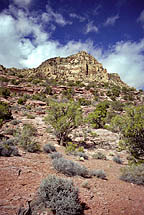
The weather looked just plain awful
as we drove east, with low hanging clouds and fog all along the horizon.
I tried to keep optimistic about the chances for clearing. We drove north
on Navajo Mountain Road, listening to our driver fret about the road conditions
when it turned into a packed clay road after about 20 miles. My directions
advocated a left turn at the fork marked by the Navajo Mt School sign.
Unfortunately, there was no sign of that type anywhere, and we took a wrong
turn at a fork with a Navajo Mt Trading Post sign. By this time, our driver
had given up trying to follow his own instinct, and was simply asking us
where to go at every turn. Some shuttle service. We drove for awhile on
that road, then decided it was going the wrong way, and had him turn around.
Stopped to ask a Navajo on horseback with three dogs directions and he
pointed us in the correct direction. Back on the right road, I told him
to turn right at the sandstone knob. He asked me what a sandstone knob
was. Clearly not a seasoned desert rat. I explained, and between Dave and
I, we managed to get the van to War God Springs, where the road gets very
sketchy. He started jerking his right arm into the air when the road turned
to 4-wheel drive, clearly getting nervous. After half a mile, we had him
stop and told him wed walk from there on, since the van was moving at
a snails pace, and the violent jostling of the long-bed vehicle was giving
me a headache. He gratefully complied, and we parted ways, paying him the
full price for the shuttle despite his getting lost and not actually getting
us to where we wanted to go. Down the trail a bit, we stopped to adjust
our packs and get things in order, glad to be out of the van and on our
own. A tremendous weight lifted as we finally reached the part of
the trip where we didnt have to rely on shuttles, campgrounds, gas stations
or restaurants. Controlling ones own destiny is a very satisfying feeling
that is hard to come by in this rush-hour society. The GPS showed us to
be but half a mile from the old Rainbow Lodge, so we felt pretty good overall.
 The
sun was hidden behind clouds to the east, but the weather had substantially
improved since the middle of the drive when it looked so bad. I started
out with my sweatshirt on, but pulled it off in about half a mile as the
uphill trail warmed me up quick. The dry desert air was intoxicating. We
reached the ruins of Rainbow Lodge, and noted a white pickup parked under
the trees, apparently belonging to two people whose footsteps we would
see along the entire trail but whose bodies remained hidden. Months ago,
I was warned not to park overnight at this spot in order to avoid automobile
vandalism. Whether that is a serious threat or not, I dont know, but it
was a factor in us deciding to take a shuttle from Wahweap Lodge. About
that time, the sun rose above the clouds that seemed to hover over Navajo
Mt, and it really warmed up. We followed the well-marked trail through
sparse juniper and yucca, some of which were sending up their annual bloom
stalk. The trail split, and we took the lower trail that switchbacked down
into a wash, First Canyon, then turned west and rose steadily up the next
ridge. The silence of the still air was welcome, and the methodical crunch
of gravel underfoot soothed like a good massage. Horse droppings littered
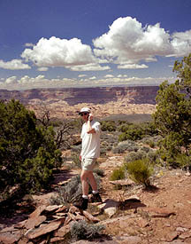
the trail, but it looked pretty old. For most of this stretch, the view
to the south and west encompassed a vast expanse of canyon country, and
I kept stretching my head around to see it as we veered to the north. Clouds
still enveloped the summit of Navajo Mt, creating a stark contrast between
the snowy, cold peak and the warm, dry canyons. At the top of the
2nd ridge, the two forks of the trail joined again, just in time for a
steep and straight shot down into Horse Canyon, which runs almost directly
east-west. The trail down ran through comforting pockets of shade, although
the steepness of the dropoff literally caused me to get dizzy while looking
down. At the bottom of the draw, I wondered how in the world we would get
out since the opposing wall was so steep. Looks can be deceiving from below
a hill, Dave pointed out, and this one was no different, as we zig-zagged
up in a lot less time than I originally thought. At the top, we shed our
packs and took a break. Amazingly, Daves cell phone was getting a signal,
so we called Matt, who almost made this trip with us, at home on Long Island
to say hello. I also called Andra and left a message on her machine since
she was still in southern California on her own little trip. The
sun was hidden behind clouds to the east, but the weather had substantially
improved since the middle of the drive when it looked so bad. I started
out with my sweatshirt on, but pulled it off in about half a mile as the
uphill trail warmed me up quick. The dry desert air was intoxicating. We
reached the ruins of Rainbow Lodge, and noted a white pickup parked under
the trees, apparently belonging to two people whose footsteps we would
see along the entire trail but whose bodies remained hidden. Months ago,
I was warned not to park overnight at this spot in order to avoid automobile
vandalism. Whether that is a serious threat or not, I dont know, but it
was a factor in us deciding to take a shuttle from Wahweap Lodge. About
that time, the sun rose above the clouds that seemed to hover over Navajo
Mt, and it really warmed up. We followed the well-marked trail through
sparse juniper and yucca, some of which were sending up their annual bloom
stalk. The trail split, and we took the lower trail that switchbacked down
into a wash, First Canyon, then turned west and rose steadily up the next
ridge. The silence of the still air was welcome, and the methodical crunch
of gravel underfoot soothed like a good massage. Horse droppings littered
the trail, but it looked pretty old. For most of this stretch, the view
to the south and west encompassed a vast expanse of canyon country, and
I kept stretching my head around to see it as we veered to the north. Clouds
still enveloped the summit of Navajo Mt, creating a stark contrast between
the snowy, cold peak and the warm, dry canyons. At the top of the
2nd ridge, the two forks of the trail joined again, just in time for a
steep and straight shot down into Horse Canyon, which runs almost directly
east-west. The trail down ran through comforting pockets of shade, although
the steepness of the dropoff literally caused me to get dizzy while looking
down. At the bottom of the draw, I wondered how in the world we would get
out since the opposing wall was so steep. Looks can be deceiving from below
a hill, Dave pointed out, and this one was no different, as we zig-zagged
up in a lot less time than I originally thought. At the top, we shed our
packs and took a break. Amazingly, Daves cell phone was getting a signal,
so we called Matt, who almost made this trip with us, at home on Long Island
to say hello. I also called Andra and left a message on her machine since
she was still in southern California on her own little trip.
Continuing on, the trail just went
higher, though I expected it to start descending. Up and up we went, with
an increasingly breathtaking view opening up to the west all the time,
and the crack of Dome Canyon yawning over a thousand feet below. Beyond
that, a sea of sandstone boiled in curves, twists and fingers, completely
obscuring any routes or passes through this land. Miles away on the horizon,
massive cliffs of the Kaiparowits Plateau rose up several thousand feet
above. I spent lots of time stopping all along the trail, and while in
subsequent camps, to take photographs. Since I had my tripod, a fully manual
camera, two lenses and two filters, setup times often lasted several minutes.
Im sure Dave got bored waiting on me, but I bribed him off by promising
to send him a CD with all the slide scans from the trip in a month or two,
so all should be well. He brought his small APS camera, but forgot to bring
film, therefore, my photographs should be of interest to him. The sky cleared
above Navajo Mt, but we were too close to see the actual summit. Before
long, we approached Yabut Pass over the massive rock wall that separates
Dome Canyon from Cliff Canyon, and stopped in the shadow cast by the wall
on the Cliff Canyon side. 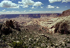 There
we ate an impromptu lunch of cheese, crackers and jerky, washed down with
Fruit Punch Gatorade. An inscription on the wall said something about suffering.
We hoped it wasnt a prediction of things to come. The drop down into Cliff
Canyon was a long, steep drop of almost 2000 feet that brought blisters
to my feet and shakes to my thighs. Lizards darted to and fro in the rocks
on the sides of the trail, appearing and disappearing like Halloween tricksters.
I scratched my legs on the abundant bitterbrush. We stopped in the cool
shade of the canyon bottom for another break, and I took some ibuprofen
for my headache that was causing blood to pound in my skull with each step. There
we ate an impromptu lunch of cheese, crackers and jerky, washed down with
Fruit Punch Gatorade. An inscription on the wall said something about suffering.
We hoped it wasnt a prediction of things to come. The drop down into Cliff
Canyon was a long, steep drop of almost 2000 feet that brought blisters
to my feet and shakes to my thighs. Lizards darted to and fro in the rocks
on the sides of the trail, appearing and disappearing like Halloween tricksters.
I scratched my legs on the abundant bitterbrush. We stopped in the cool
shade of the canyon bottom for another break, and I took some ibuprofen
for my headache that was causing blood to pound in my skull with each step.
We looked around in the creek for
water, and found none, making us a little nervous. I had brought a gallon,
and so had Dave, but that wouldnt last us two days so we had to find water
somewhere. We continued on, mostly in the shade, along a gentle, sand trail
that had few obstacles. From that point on, the tough hiking was 95% done
with, and we reveled in the soft, flat trail by Cliff Creek. It had taken
us almost 4 hours to get to Cliff Creek, so we basically decided to plop
down at the first good spot we found. There was a lot more vegetation
in the canyon than I had expected, thinking it would be something like
the Needles District at Canyonlands. It was not. Willow and juniper 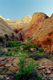 provided
a relatively dense canopy in spots, while the ground was covered with prickly
pear, blooming red penstemon, sharp yucca and soft clumps of new Indian
Rice Grass and Cheatgrass. A few puddles came into view, and we grew hopeful.
We passed them by, and soon there were regular pools of water, some looking
more tasty than others. The first spot we checked would have been perfect
a nice flat sandy ledge above the creek with water nearby had it not
been for the incredibly robust prickly pear population. We found a few
small flat spots that were cactus-free, but neither of us was thrilled
with the spot. We left our gear there and explored downstream and found
a great spot that was open, sandy, cactus-free and near water. So, back
up to get our stuff, down canyon once again about 100 yards. There we relaxed,
pulled off our boots and sat in the shade sipping Gatorade. I should try
to describe this campsite, but a picture will do better. It was all
fine and well, but soon we became restless and decided to go exploring. provided
a relatively dense canopy in spots, while the ground was covered with prickly
pear, blooming red penstemon, sharp yucca and soft clumps of new Indian
Rice Grass and Cheatgrass. A few puddles came into view, and we grew hopeful.
We passed them by, and soon there were regular pools of water, some looking
more tasty than others. The first spot we checked would have been perfect
a nice flat sandy ledge above the creek with water nearby had it not
been for the incredibly robust prickly pear population. We found a few
small flat spots that were cactus-free, but neither of us was thrilled
with the spot. We left our gear there and explored downstream and found
a great spot that was open, sandy, cactus-free and near water. So, back
up to get our stuff, down canyon once again about 100 yards. There we relaxed,
pulled off our boots and sat in the shade sipping Gatorade. I should try
to describe this campsite, but a picture will do better. It was all
fine and well, but soon we became restless and decided to go exploring.
Because of the winding nature of the
canyon, one couldnt see down- or up-canyon very far at all. Numerous fins
overlapped to block the view. Between each of these fins was a side canyon
just waiting to be explored. We happened to have a deep looking side canyon
just to the north of our camp, so we walked up there right away. First
we crossed a gentle slope of grass, yucca and juniper that led out of the
warm sunlight into the cool shade, then we hit a solid sandstone slope
and walked quietly uphill. A sandy strip with grass and redbud lay between
two 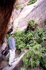 opposingly-tilted
planes of rock. The purple blossoms of the redbud sweetened the air. The
draw grew thinner, and steeper, and soon it was a matter of strict concentration
to avoid slipping all the way to the bottom of the giant V we were now
traversing. I appreciated the grip of my lug-soled boots. The walls
stretched a couple hundred feet above, blocking out almost all light. As
the walls drew closer, the dark shade cooled the air even more. Along one
wall, a long, horizontal seep had created a profuse hanging garden of maiden
hair fern, moss, and a few other plants that Id never seen before, perhaps
being too rare to put in field guides. The walls became steep enough to
necessitate the use of both hands, so I had to cache my tripod and take
along just the camera on my back. With feet on one wall, and hands pressing
against the other, we managed to make it past a particularly steep spot
that opened up beyond into a less steep area that was quiet, dark and very
lush with riparian species living off the slow seeping water pressing through
the crack in the wall. There the path ended, as the far side of this
little room was way too steep for anybody to manage. The box end foiled
us, and we turned back, but not disappointed by any stretch. In fact, this
little side canyon exploration was my personal favorite moment of the trip.
From the high point on our way out we could look across Cliff Creek to
the other promising chutes and draws and see that they led nowhere in a
big hurry. Dave had opted out of his hiking boots for this little trip,
but paid for that choice by stabbing his toe on a yucca leaf that quickly
embedded itself under the skin, and required minor surgery with a needle
to remove back at camp. We walked down canyon to the next draw and began
climbing up toward it, but before we got very far, we could see it was
too steep to try, and we went back to camp. opposingly-tilted
planes of rock. The purple blossoms of the redbud sweetened the air. The
draw grew thinner, and steeper, and soon it was a matter of strict concentration
to avoid slipping all the way to the bottom of the giant V we were now
traversing. I appreciated the grip of my lug-soled boots. The walls
stretched a couple hundred feet above, blocking out almost all light. As
the walls drew closer, the dark shade cooled the air even more. Along one
wall, a long, horizontal seep had created a profuse hanging garden of maiden
hair fern, moss, and a few other plants that Id never seen before, perhaps
being too rare to put in field guides. The walls became steep enough to
necessitate the use of both hands, so I had to cache my tripod and take
along just the camera on my back. With feet on one wall, and hands pressing
against the other, we managed to make it past a particularly steep spot
that opened up beyond into a less steep area that was quiet, dark and very
lush with riparian species living off the slow seeping water pressing through
the crack in the wall. There the path ended, as the far side of this
little room was way too steep for anybody to manage. The box end foiled
us, and we turned back, but not disappointed by any stretch. In fact, this
little side canyon exploration was my personal favorite moment of the trip.
From the high point on our way out we could look across Cliff Creek to
the other promising chutes and draws and see that they led nowhere in a
big hurry. Dave had opted out of his hiking boots for this little trip,
but paid for that choice by stabbing his toe on a yucca leaf that quickly
embedded itself under the skin, and required minor surgery with a needle
to remove back at camp. We walked down canyon to the next draw and began
climbing up toward it, but before we got very far, we could see it was
too steep to try, and we went back to camp.
We filtered water from one of the
large, still pools in the creek bed, then cooked dinner of 3 cheese rotini
and complemented that with jerky. Nothing but the best. Dave ceremoniously
devoured his Twix bar, carefully preserved 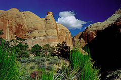 for
just this moment. I decided to save mine for the following night.
We arranged our sleeping pads out in the open on a flat sand patch, hidden
from the trail by a series of very large black rocks. I strolled around
looking at plants and rocks, and while jumping from a high rock to the
sand below rammed my knee into a yucca plant that immediately drew blood
which soaked through the thin quick-drying fabric of my pants. Those darn
things are pretty vicious. I noted that many yucca along the way had been
browsed and I found it hard to believe that any animal could find such
tough fibrous leaves palatable. for
just this moment. I decided to save mine for the following night.
We arranged our sleeping pads out in the open on a flat sand patch, hidden
from the trail by a series of very large black rocks. I strolled around
looking at plants and rocks, and while jumping from a high rock to the
sand below rammed my knee into a yucca plant that immediately drew blood
which soaked through the thin quick-drying fabric of my pants. Those darn
things are pretty vicious. I noted that many yucca along the way had been
browsed and I found it hard to believe that any animal could find such
tough fibrous leaves palatable.
As the sun set, the shadows in the
canyon became cool, and by dark it was fairly chilly. The stars came out
in a crystal clear sky, and I attempted evening star shots as Dave drifted
off to sleep. We were talking most of the evening, and then suddenly, Dave
stopped answering. I shut up and took more pictures. Frogs croaked like
mechanical sheep down the canyon, suggesting more abundant water in that
direction. Despite the pools of water, insects were pretty scarce. I took
a few shots around 9 PM, but felt too tired to stay up any later bothering
with that. I laid the tripod down on the ground, and put my camera away.
An owl made his presence known somewhere nearby. I fell asleep very quickly,
waking up in the middle of the night only once when Dave, who was sleeping
about 8 feet away, poked me with my camera tripod trying to get me to stop
snoring.
|