| Sunday, April 20
 It
was a chilly night, and I slept with my head buried inside the bag. Several
times I poked my head out of the bag to watch the stars, in their unpolluted
clarity, for a few seconds before going back to sleep. As morning approached,
birds began singing, and the bright light of dawn hurt my eyes. When I
finally got up around 6:30, the outside of my bag was soaked. The entire
canyon was in shadow, but I could see a single sliver of golden sandstone
far off down the canyon where the sun was shining. The sky was cloudless.
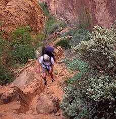
In the chilly morning air, I got dressed as Dave woke up. Due to the wet
bags, we decided to wait until the sun was in camp to dry things out before
leaving, contrary to the original plan of getting to the bridge as soon
as we could. Therefore, I walked down the canyon to see if there were any
good morning photographic opportunities. Very shortly on my walk downstream
I came upon running water, coming from some unseen and unknown seep in
one of the numerous side chutes winding up and out of sight on both sides
of the creek. This has been described as a permanent spring called First
Water by numerous authors, and has a couple of well-used campsites nearby.
The running water provided suitable habitat for cat tails, Equisetum and
tall reedy grasses, in addition to redbuds, box elders and willows. Some
of the healthiest Ephedra plants Ive ever seen reside here. In the jungle-like
canyon bottom, I bulled my way down the narrow, overgrown trail, where
off to the left sat a wooden outhouse, seeming very out of place in this
completely remote area, but confirming that this area has historically
been an overnight stop for hikers and packers. An occasional mosquito
would buzz in my face, but the bugs were surprisingly and pleasantly few.
A little further down I found a side chute that looked shallow enough for
my boots to grip, and walked up. Halfway, the pitch steepened, and I cached
my camera on a ledge so I could use both my hands. I didnt go more than
50 or 60 feet up before I reached a dome that hung out over the creek.
Hoping I could see camp from there, I got to the top, but the view up canyon
was blocked by an intervening fin. I slowly scooted down and returned to
camp. It
was a chilly night, and I slept with my head buried inside the bag. Several
times I poked my head out of the bag to watch the stars, in their unpolluted
clarity, for a few seconds before going back to sleep. As morning approached,
birds began singing, and the bright light of dawn hurt my eyes. When I
finally got up around 6:30, the outside of my bag was soaked. The entire
canyon was in shadow, but I could see a single sliver of golden sandstone
far off down the canyon where the sun was shining. The sky was cloudless.
In the chilly morning air, I got dressed as Dave woke up. Due to the wet
bags, we decided to wait until the sun was in camp to dry things out before
leaving, contrary to the original plan of getting to the bridge as soon
as we could. Therefore, I walked down the canyon to see if there were any
good morning photographic opportunities. Very shortly on my walk downstream
I came upon running water, coming from some unseen and unknown seep in
one of the numerous side chutes winding up and out of sight on both sides
of the creek. This has been described as a permanent spring called First
Water by numerous authors, and has a couple of well-used campsites nearby.
The running water provided suitable habitat for cat tails, Equisetum and
tall reedy grasses, in addition to redbuds, box elders and willows. Some
of the healthiest Ephedra plants Ive ever seen reside here. In the jungle-like
canyon bottom, I bulled my way down the narrow, overgrown trail, where
off to the left sat a wooden outhouse, seeming very out of place in this
completely remote area, but confirming that this area has historically
been an overnight stop for hikers and packers. An occasional mosquito
would buzz in my face, but the bugs were surprisingly and pleasantly few.
A little further down I found a side chute that looked shallow enough for
my boots to grip, and walked up. Halfway, the pitch steepened, and I cached
my camera on a ledge so I could use both my hands. I didnt go more than
50 or 60 feet up before I reached a dome that hung out over the creek.
Hoping I could see camp from there, I got to the top, but the view up canyon
was blocked by an intervening fin. I slowly scooted down and returned to
camp.
Upon my return, we discussed the timing
of the day, and decided that since the sun had not yet even touched the
top of the canyon walls, a considerable delay would be inevitable should
we continue to wait for the sun to dry things out prior to leaving. We
decided to leave, and dry bags out later. We  quickly
packed up camp and took off. As we approached the side chute on the right
of the canyon that I had earlier ascended, I pointed out a much more robust
side canyon on the opposite wall that looked worth exploring. Dave agreed.
We shed our packs right next to the trail and took off up the steep, grassy
slope that led up like a stairway between two unscalable rock walls. The
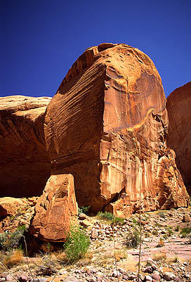
shadow-cloaked slope was very steep, and we dodged the yucca and cactus
on our separate routes up. Giant angular choke stones, calved from the
towering walls above perhaps before men walked on two legs, provided soil
anchors that kept the entire canyon from being a smooth rock wash. Sweet-smelling
redbud provided the most difficult obstacle to getting up as I bent and
wormed my way under their low-hanging limbs. After several hundred
feet, the canyon forked, and we took the smaller, narrower left fork into
a short box canyon that ended in an abrupt wall. The entrance to this canyon
was no more than 6 feet wide, but opened up inside to about 15 feet. An
overhanging spout, stained by metal oxides from centuries of intermittent
water flow, hung directly over a perfectly smooth sandstone bowl filled
with cold, dark water. The round pool was about 10 feet in diameter, hidden
like a treasure in this indistinct and small cove. A side canyon of a side
canyon of a side canyon of Glen Canyon. We backed out of the narrow opening,
and continued on up the main drainage. We reached a spot after several
hundred more feet where the slope converged with the left wall so that
we could walk out on top of a huge sandstone dome. Far from being smooth,
the surface of this dome was covered with tiny 1mm spikes that pricked
my ass as I sat down. From the vantage point, we could look down
and see our starting point by the Cliff Creek, as well as ascertain that
if time allowed, we could continue on up the side canyon indefinitely,
perhaps all the way to the top of the towering cliffs at the top of the
horizon. Time, unfortunately, did not allow such an excursion. Perhaps
another day. With so many places to see in this world, and only 60 walking
years to see it in (if one is lucky), I think the chances that I will go
back to visit that particular side canyon in that remote corner of Lake
Powell are slim to none. Such a sentiment compels me to take as many photographs
and notes as I can on each place I visit, since I know I will visit few
of them a second time. So many canyons. So little time. quickly
packed up camp and took off. As we approached the side chute on the right
of the canyon that I had earlier ascended, I pointed out a much more robust
side canyon on the opposite wall that looked worth exploring. Dave agreed.
We shed our packs right next to the trail and took off up the steep, grassy
slope that led up like a stairway between two unscalable rock walls. The
shadow-cloaked slope was very steep, and we dodged the yucca and cactus
on our separate routes up. Giant angular choke stones, calved from the
towering walls above perhaps before men walked on two legs, provided soil
anchors that kept the entire canyon from being a smooth rock wash. Sweet-smelling
redbud provided the most difficult obstacle to getting up as I bent and
wormed my way under their low-hanging limbs. After several hundred
feet, the canyon forked, and we took the smaller, narrower left fork into
a short box canyon that ended in an abrupt wall. The entrance to this canyon
was no more than 6 feet wide, but opened up inside to about 15 feet. An
overhanging spout, stained by metal oxides from centuries of intermittent
water flow, hung directly over a perfectly smooth sandstone bowl filled
with cold, dark water. The round pool was about 10 feet in diameter, hidden
like a treasure in this indistinct and small cove. A side canyon of a side
canyon of a side canyon of Glen Canyon. We backed out of the narrow opening,
and continued on up the main drainage. We reached a spot after several
hundred more feet where the slope converged with the left wall so that
we could walk out on top of a huge sandstone dome. Far from being smooth,
the surface of this dome was covered with tiny 1mm spikes that pricked
my ass as I sat down. From the vantage point, we could look down
and see our starting point by the Cliff Creek, as well as ascertain that
if time allowed, we could continue on up the side canyon indefinitely,
perhaps all the way to the top of the towering cliffs at the top of the
horizon. Time, unfortunately, did not allow such an excursion. Perhaps
another day. With so many places to see in this world, and only 60 walking
years to see it in (if one is lucky), I think the chances that I will go
back to visit that particular side canyon in that remote corner of Lake
Powell are slim to none. Such a sentiment compels me to take as many photographs
and notes as I can on each place I visit, since I know I will visit few
of them a second time. So many canyons. So little time.
The trip back down the side canyon
took very little time, and before we could turn around, we were back at
the creek, chugging water and having a snack. After hiking another
½ mile or so, we stopped again to filter water from Cliff Creek
before leaving it to cross Redbud Pass. The water in Cliff Creek was good,
and plentiful, but we didnt  know
what to expect in Redbud Creek. We also took the time to apply sun screen.
Dave, who comes from upstate NY, and hasnt seen the sun in 10 months,
burned his legs and elbows by not applying sun screen to those spots the
previous day. I escaped such a fate, but had terrible blisters on my feet
which he seemed immune to. To each his own. We skinned an orange and downed
it, then continued on under a perfect, and I mean perfect, blue desert
sky. I dont know if its the contrast between the orange rock and blue
sky, or whether the dry air makes colors more vibrant, but Ive just never
seen such a blue sky anywhere but in canyon country. know
what to expect in Redbud Creek. We also took the time to apply sun screen.
Dave, who comes from upstate NY, and hasnt seen the sun in 10 months,
burned his legs and elbows by not applying sun screen to those spots the
previous day. I escaped such a fate, but had terrible blisters on my feet
which he seemed immune to. To each his own. We skinned an orange and downed
it, then continued on under a perfect, and I mean perfect, blue desert
sky. I dont know if its the contrast between the orange rock and blue
sky, or whether the dry air makes colors more vibrant, but Ive just never
seen such a blue sky anywhere but in canyon country.
 Near
Redbud Pass, we noted an old wooden shelter, shaped like a teepee. Perhaps
part of the Rainbow Lodge accommodations from the 1950s? Who knows? There
are no informational placards out here, and it is good to have some mysteries
left unsolved. As we turned right into Redbud Pass, Cliff Canyon
continued on and out of sight around a right bend, quietly beckoning us
to explore its lonely depths. Again, we had no time to do so. Redbud Pass
still confounds me with its steepness. Looking at a highly detailed 7.5
quad map, I cant count more than 2 contour lines (at 40 feet each) that
must be crossed to reach the top of Redbud Pass, yet the elevation gain
is several hundred feet, at least. Probably the most dramatic narrow-canyon
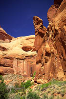
section of the entire route is that through Redbud Pass, where two massive,
near-vertical walls frame a trail in places just wide enough to lead a
horse through. The steepness is compounded by the loose sand trail, which
makes it hard to get a good footing. The pass is aptly named, as hundreds
of redbuds line the thin corridor. The sweet smell of their tiny purple
blossoms freshened the air beyond description. Other flowers lent color
to the pass. Indian paintbrush bloomed red in profusion, and I saw a single
claretcup cactus in full bloom, its blood-red petals standing out like
neon against the shadows of the juniper trees. The sandy flats where
the soil was deeper were covered with prairie wild onions, their numerous
blooms appearing almost like purple and white striped ribbon candy, and
there was no mistaking their pungent aroma. One could tell the trail was
not well traveled since grass and lupine grew right in the middle of the
path. Near
Redbud Pass, we noted an old wooden shelter, shaped like a teepee. Perhaps
part of the Rainbow Lodge accommodations from the 1950s? Who knows? There
are no informational placards out here, and it is good to have some mysteries
left unsolved. As we turned right into Redbud Pass, Cliff Canyon
continued on and out of sight around a right bend, quietly beckoning us
to explore its lonely depths. Again, we had no time to do so. Redbud Pass
still confounds me with its steepness. Looking at a highly detailed 7.5
quad map, I cant count more than 2 contour lines (at 40 feet each) that
must be crossed to reach the top of Redbud Pass, yet the elevation gain
is several hundred feet, at least. Probably the most dramatic narrow-canyon
section of the entire route is that through Redbud Pass, where two massive,
near-vertical walls frame a trail in places just wide enough to lead a
horse through. The steepness is compounded by the loose sand trail, which
makes it hard to get a good footing. The pass is aptly named, as hundreds
of redbuds line the thin corridor. The sweet smell of their tiny purple
blossoms freshened the air beyond description. Other flowers lent color
to the pass. Indian paintbrush bloomed red in profusion, and I saw a single
claretcup cactus in full bloom, its blood-red petals standing out like
neon against the shadows of the juniper trees. The sandy flats where
the soil was deeper were covered with prairie wild onions, their numerous
blooms appearing almost like purple and white striped ribbon candy, and
there was no mistaking their pungent aroma. One could tell the trail was
not well traveled since grass and lupine grew right in the middle of the
path.
 By
the top of Redbud Pass, marked by a wooden sign held up by a rock pile,
my feet were in agony from blisters that had developed and intensified
on my toes and the ball of each foot. I removed shoes to inspect the damage,
found several blisters already ruptured, and decided there was little I
could do but try to ignore the stinging. The way down Redbud Pass, toward
Redbud Creek, was much more rugged than the way up. I had read that someone
spent a lot of time trying to improve the trail with dynamite and shovel
work back in the 1920s to make it passable to pack animals. If at one
time horses could descend this route, they would surely not be able to
now. Several 6-7 foot drop-offs required cautious descents with all four
limbs. To get back up I am sure one would have to do a bit of scrambling,
but I have heard from those who were able to make it up without ropes and
with packs just fine. Nevertheless, we began to appreciate even more the
one-way design of our trip. We slowly picked our way down a boulder
field between the two rock walls, and I wondered if we had somehow lost
the trail. No other conceivable route existed, however, so we continued
down at a snails pace, cautiously testing each step to make sure each
rock wouldnt bound down the hill with one of us on it. As the terrain
leveled, the distinct outline of the trail returned, and we were able to
once again walk in comfort. The trail remained a track through a crack
in the rock, almost like a tunnel, and truly a tunnel as it wound between
a vertical rock wall on the left, and vigorous white oak thickets on the
right that covered the trail from above. Flecks of sunlight scattered on
the soft sand of the trail, and the cool shadows felt very refreshing.
The temperature was rising as we were descending towards the river, or
what is now the lake, and we were both sure to keep drinking plenty of
fluids to fend off any uncomfortable side effects of dehydration. By
the top of Redbud Pass, marked by a wooden sign held up by a rock pile,
my feet were in agony from blisters that had developed and intensified
on my toes and the ball of each foot. I removed shoes to inspect the damage,
found several blisters already ruptured, and decided there was little I
could do but try to ignore the stinging. The way down Redbud Pass, toward
Redbud Creek, was much more rugged than the way up. I had read that someone
spent a lot of time trying to improve the trail with dynamite and shovel
work back in the 1920s to make it passable to pack animals. If at one
time horses could descend this route, they would surely not be able to
now. Several 6-7 foot drop-offs required cautious descents with all four
limbs. To get back up I am sure one would have to do a bit of scrambling,
but I have heard from those who were able to make it up without ropes and
with packs just fine. Nevertheless, we began to appreciate even more the
one-way design of our trip. We slowly picked our way down a boulder
field between the two rock walls, and I wondered if we had somehow lost
the trail. No other conceivable route existed, however, so we continued
down at a snails pace, cautiously testing each step to make sure each
rock wouldnt bound down the hill with one of us on it. As the terrain
leveled, the distinct outline of the trail returned, and we were able to
once again walk in comfort. The trail remained a track through a crack
in the rock, almost like a tunnel, and truly a tunnel as it wound between
a vertical rock wall on the left, and vigorous white oak thickets on the
right that covered the trail from above. Flecks of sunlight scattered on
the soft sand of the trail, and the cool shadows felt very refreshing.
The temperature was rising as we were descending towards the river, or
what is now the lake, and we were both sure to keep drinking plenty of
fluids to fend off any uncomfortable side effects of dehydration.
Redbud Pass drops hikers into Redbud
Creek, which has a spectacular canyon of its own. I dont recall looking
up-canyon, but that probably would be a great place to go explore. Once
again, if I ever come back
. Hardly a stones throw from where the trail
intersects Redbud Creek, Redbud Creek intersects Bridge Creek in Bridge
Canyon, and the trail from Navajo Mt Trading Post, which was the original
trail to Rainbow Bridge established in the teens after the white-man discovery
of Rainbow Bridge in 1909. This was the real sign that we were getting
very close. Bridge Canyon was much wider than Cliff Canyon, and seemed
to have taller walls, although I think this may just be a consequence of
having fewer side canyons and corresponding ridges. The walls were mostly
sheer and vertical, with numerous giant overhangs that sheltered inviting
campsites. Bridge Creek ran with more volume, although we found out
later the taste was definitely inferior to Cliff Creek, for whatever reason.
 The
temperature approached the mid seventies, and we stopped for a break at
a bend in the creek. I ate some cheese and crackers and aired out my boots.
The down-canyon breeze in the shade almost made it feel cold, so both Dave
and I oscillated between sitting in the warm sun, and the cool shade. I
pulled out a map and pondered the possibilities. Rainbow Bridge lies in
the middle of its own small, square National Monument covering 160 acres,
or about 2/3 square mile. No camping is allowed within the monument, but
since that was what we came to see, we wanted to camp as close to it as
possible while staying on Reservation land. The
temperature approached the mid seventies, and we stopped for a break at
a bend in the creek. I ate some cheese and crackers and aired out my boots.
The down-canyon breeze in the shade almost made it feel cold, so both Dave
and I oscillated between sitting in the warm sun, and the cool shade. I
pulled out a map and pondered the possibilities. Rainbow Bridge lies in
the middle of its own small, square National Monument covering 160 acres,
or about 2/3 square mile. No camping is allowed within the monument, but
since that was what we came to see, we wanted to camp as close to it as
possible while staying on Reservation land.
Conversation turned to our plans for
camping on the road after the boat picked us up and dropped us off at Wahweap
Lodge the next afternoon. Since camping along the road is forbidden inside
the reservation, and since it takes at least 2 hours to drive to Mexican
Hat, the first town outside of the reservation on the way back east, we
decided that the afternoon boat would come too late for us to do anything
but camp once again at Wahwap Marina. Neither of us wanted to do that again.
Therefore, we decided that seeing the bridge for the next 12 hours was
enough, and we would attempt to take the morning tour boat back to Wahweap,
arrive there by 3 and hopefully get to a BLM campsite north of Mexican
Hat by dark.
We put our packs back on and continued,
knowing we were close, and keeping our eyes open for possible campsites.
Several appeared, and we made mental notes. Since it was very tough to
say where the boundary was, the plan evolved into "hike to the boundary,
then turn around and camp in the first good spot". We followed the trail
until it started to climb steeply away from the creek. Figuring we were
close to the bridge, we decided that the trail must eventually meet the
creek, and followed a well-defined trail down to the creek and followed
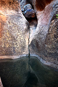
it. The creek bed was solid rock for a spell, and a spout fell into a deep
pool of greenish water that was at least 10 feet deep and ran in a channel
for about 30 feet, being about 10 feet wide. If it were a hot summer day
I wouldve hopped right in, but the water wouldve been far too cold for
that while we were there. The creek bed drew narrower, and the walls steeper,
until we could go no further, and realized the futility of our effort to
hug the creek. We figured the trail was up above somewhere, and that if
we climbed far enough, wed reach it. It is amazing how fast we descended
so far 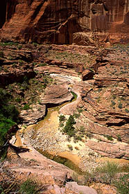 below
the trail, for while we were walking downhill, it was leading steeply uphill.
The result was that we had to climb over a hundred feet of treacherous
60-70 degree slope to get back on the trail. While resting at the top after
the arduous climb up, Dave studied the map, and determined that we would
not be able to get down to the creek until well inside the monument, and
since camping hinged on good water, we turned back to the previously-sited
spot that had ample water and good tent sites. We set down our packs for
the day at 12, about 5 hours after starting out from camp that morning. below
the trail, for while we were walking downhill, it was leading steeply uphill.
The result was that we had to climb over a hundred feet of treacherous
60-70 degree slope to get back on the trail. While resting at the top after
the arduous climb up, Dave studied the map, and determined that we would
not be able to get down to the creek until well inside the monument, and
since camping hinged on good water, we turned back to the previously-sited
spot that had ample water and good tent sites. We set down our packs for
the day at 12, about 5 hours after starting out from camp that morning.
This campsite was marvelous. Giant
planks of flat, though rippled, rock (and I dont think it was sandstone)
formed a multi-leveled platform that overlooked a large, waist-deep pool
of crystal clear water that had water rushing both in and out, filling
and emptying simultaneously, in perpetuity. A sandy beach provided a perfect
tent site, after Dave excavated a giant rock from the middle, while the
flat rocks provided perfect sitting and cooking areas. The rocks above
the pool provided a perfect seat to sit and soak tired, hot feet in the
cold water, which we did as soon as we arrived. We pulled out our wet sleeping
bags and dried them in minutes under the mid day sun. I doctored my blisters
by lancing them and applying bandages while Dave tended to his severely
burned legs. Within an hour of staking our claim, we put a couple of water
bottles in a bag and took off up the trail (not detouring by the creek
this time). We passed through a dilapidated barbed-wire gate, then followed
a flat trail around a deep and thin wash. At the source of this wash lay
the old tourist camp, Echo Camp, complete with rusting bed frames and cottage
foundations. It was all fenced off, perhaps for archeological and historical
reasons. It didnt look like an inviting place to explore anyway so we
werent disappointed to be herded along by the obstacles. I was much happier
with our open camp than I wouldve been in this overgrown alcove.
The trail stayed pretty flat as it
side-hilled around the slopes and gulleys, weaving left and right between
side-rails of rocks, laboriously stacked along both sides. The open, flat
areas to the right of the trail harbored an abundance of plant life. Delicate
white evening primrose and fading Utah daisies were the most abundant,
but individual desert trumpets and scattered blooming fishhook cactus provided
more color. Once again, I was impressed by the diversity and abundance
of plant life in the thin strip of green along the canyon bottom. While
the trail stayed more or less level, the creek bed fell sharply away, and
soon was clearly inaccessible without climbing gear. I was walking in front
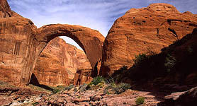
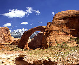
on the trail, and Dave caught first sight of part of Rainbow Bridge off
down the canyon and pointed it out. It was much closer to the monument
boundary than I had expected, but there it was, a tremendous arch that
appeared tiny against the enormous canyon walls and buttes rising around
it.
 We
hiked on, and crossed through the Park Service gate, where signs clearly
indicate that it is forbidden to do much of anything within the park, such
as swimming, camping, fishing, rock-climbing, boating, etc. I jokingly
commented that we shouldnt breath too much either. The afternoon sunlight
was brilliant, and it lit up Rainbow Bridge in harsh, raw light that contrasted
deeply with the deep, dark shadows on the walls and below in Bridge Creek.
As we approached the bridge, a rock wall on the right held two large copper
plaques, one commemorating Jim Mike and the other Nasja Begay, the two
Native Americans present when the first white men viewed Rainbow Bridge.
I had read previously that the Park Service requests visitors to refrain
from walking under the bridge in respect of Navajo religious beliefs. Much
is written on Park Service placards and brochures about how sacred this
site is to the Native Americans, but I question that. For example, when
rumors of the bridge came to Anglo ears in about 1907, they contained language
like, "only a few go there", "not remember the prayers" or "not many know
the way". When Byron Cummings and William Douglass, two Anglo expedition
leaders, sought guides for this rumored bridge in 1909, they could find
only a few Native Americans who had ever even heard of the bridge, or at
least who would admit to knowledge of it. The expedition leader from Utah
State University, Byron Cummings, hired a Navajo named Dogeye Begay, while
Douglass, a General Land Office employee, hired a Piute called Jim Mike.
After several days of searching, neither was able to guide the expeditions
anywhere near the bridge, and had never actually seen it. Only the appearance
of Dogeye Begays father, Nasja, saved the now-joint expedition from collapse
since he alone seemed to know the way (Hassell, 1999). I dont want
to step on any toes, and if someone decides something is sacred, thats
their right. What Im saying is that the picture the Park Service paints
of regular visits to Rainbow Bridge by masses of Native Americans for the
last several centuries in a sort of Mecca pilgrimmage just doesnt seem
to be accurate. The historical record shows it is more likely that
some natives visited it occasionally, but the majority never did.
Personally, I dont see how walking under or approaching Rainbow Bridge
is disrespectful. I didnt walk 13 miles through canyons to disrespect
a piece of rock. I walked 13 miles to see a natural creation of beauty,
and I dont think that any position of my body means much at all to the
rock. In 1995, a group of Native Americans calling themselves "Protectors
of the Rainbow" barricaded the trail to the bridge, and protested with
signs the deplorable standard of living on the Navajo Reservation. Some
were photographed climbing on top of Rainbow Bridge. Is that religious
reverence? Nevertheless, Dave and I walked up a We
hiked on, and crossed through the Park Service gate, where signs clearly
indicate that it is forbidden to do much of anything within the park, such
as swimming, camping, fishing, rock-climbing, boating, etc. I jokingly
commented that we shouldnt breath too much either. The afternoon sunlight
was brilliant, and it lit up Rainbow Bridge in harsh, raw light that contrasted
deeply with the deep, dark shadows on the walls and below in Bridge Creek.
As we approached the bridge, a rock wall on the right held two large copper
plaques, one commemorating Jim Mike and the other Nasja Begay, the two
Native Americans present when the first white men viewed Rainbow Bridge.
I had read previously that the Park Service requests visitors to refrain
from walking under the bridge in respect of Navajo religious beliefs. Much
is written on Park Service placards and brochures about how sacred this
site is to the Native Americans, but I question that. For example, when
rumors of the bridge came to Anglo ears in about 1907, they contained language
like, "only a few go there", "not remember the prayers" or "not many know
the way". When Byron Cummings and William Douglass, two Anglo expedition
leaders, sought guides for this rumored bridge in 1909, they could find
only a few Native Americans who had ever even heard of the bridge, or at
least who would admit to knowledge of it. The expedition leader from Utah
State University, Byron Cummings, hired a Navajo named Dogeye Begay, while
Douglass, a General Land Office employee, hired a Piute called Jim Mike.
After several days of searching, neither was able to guide the expeditions
anywhere near the bridge, and had never actually seen it. Only the appearance
of Dogeye Begays father, Nasja, saved the now-joint expedition from collapse
since he alone seemed to know the way (Hassell, 1999). I dont want
to step on any toes, and if someone decides something is sacred, thats
their right. What Im saying is that the picture the Park Service paints
of regular visits to Rainbow Bridge by masses of Native Americans for the
last several centuries in a sort of Mecca pilgrimmage just doesnt seem
to be accurate. The historical record shows it is more likely that
some natives visited it occasionally, but the majority never did.
Personally, I dont see how walking under or approaching Rainbow Bridge
is disrespectful. I didnt walk 13 miles through canyons to disrespect
a piece of rock. I walked 13 miles to see a natural creation of beauty,
and I dont think that any position of my body means much at all to the
rock. In 1995, a group of Native Americans calling themselves "Protectors
of the Rainbow" barricaded the trail to the bridge, and protested with
signs the deplorable standard of living on the Navajo Reservation. Some
were photographed climbing on top of Rainbow Bridge. Is that religious
reverence? Nevertheless, Dave and I walked up a 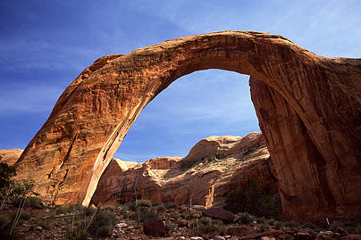 hill
and around the east end of the bridge, and down the other side, probably
contributing much more to erosion than if we had simply walked underneath.
It all seems so politicized and frankly ridiculous. hill
and around the east end of the bridge, and down the other side, probably
contributing much more to erosion than if we had simply walked underneath.
It all seems so politicized and frankly ridiculous.
When we reached flat ground, we were
confronted with a herd of people gathered behind a stone barricade that
we were now on the wrong side of. Rainbow Bridge also serves as a gateway,
holding back the Park Service signs, pavements and shelters that litter
the west side of the bridge. Dozens of brown and white signs proclaimed
"Area Closed" and "We ask for your voluntary cooperation in not approaching
or walking under Rainbow Bridge." We got a few stares as we stepped onto
the paved Park Service viewing area, but heck, how else do you get to the
other side if not by crossing this line? We asked a guy if they were with
the tour boat, but they werent, so we decided to walk down to the dock
to meet the tour boat that was supposed to arrive at 3:00 and see if we
could alter our reservation for the following day. Along the wide,
flat, boulder-lined trail leading down canyon, I stopped to take several
photographs of Rainbow Bridge with snow-dusted Navajo Mt in the background.
Every 50 feet a Park Service sign proclaimed "Area Closed". I was frustrated
at the ugly signs and their unavoidable presence. In one photograph, I
had Dave stand in front of a sign to hide it. The trail was very deliberate,
with obvious signs of heavy earth-moving equipment use and backfill. Tire
tracks criss-crossed the trail. Slopes of rock seemed out of place. The
lake was very low, the lowest it had ever been since it reached full level
at 3700 feet in June of 1980, and the thirty or forty feet of white scum
on the rock above the waterline, the bathtub ring, showed the high point.
Dozens of steel hooks and rusted cables hung limply from the walls, dock
anchor points from previous high-water level years. Steel culverts and
PVC drains channeled water under the trail to prevent erosion. The entire
effect was one of a construction site in its early stages, and after the
pristine beauty and small trail in Cliff and Bridge Canyons, the scene
left a bad taste in my mouth. This is industrialized nature, and it is
revolting. It is also the only nature most ever see.
Because of the low water level, the
floating boat dock was at the very limit of the Monument on the NW side,
about 1.2 miles from the bridge, according to the Park Service employee
we consulted there. In high water years the dock is moved up canyon
to give fat tourists a better chance to waddle up the trail and see it.
Over 150 yards in length, the dock stretched as a floating 10 foot sidewalk
far out into the waters of Lake Powell, confined in the narrow walls of
Bridge Canyon. It has rails, trashcans and a floating 6 flush-toilet comfort
station coated in tasteful faux-adobe. Numerous boats were docked, but
none looked to be a tour boat. We discussed the possible arrival of a tour
boat with the Park Service man, and he confirmed what we had heard, that
they only make the trip if they have enough paying customers, and might
not show up today at all. We sat and waited on the dock, and entertained
ourselves by throwing Ritz cracker bits to the giant 2 foot carp and striped
bass swarming beneath the dock. On the far side of the dock, on the canyon
wall just below high water line, lay a huge pile of bleached tree skeletons,
stranded on a ledge above the water. Their cracked and slimed limbs providing
a dismal reminder of the unwholesome depths of water in the canyon. Soon,
all boats departed, and we were alone on the quiet dock. I walked out to
the end to look down 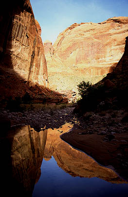 the
canyon, but as in all the others, the twisting, sinuous curves of the rock
blocked out all vision after a couple hundred yards. At 5 after 3, we gave
up on the boat, and by 15 after, we left the dock behind. Apparently the
boat arrived just minutes later, because as we took group pictures in front
of Rainbow Bridge, a herd of folks came around the bend after us. Thus,
we were able to gain an audience with Doug, the tour boat driver, and he
told us there would be no problem in catching the early boat the next day.
With that reassurance, we peeled ourselves away from an old man telling
us a highly detailed story about kayakers in Alaska, and blatantly disobeyed
the "Area Closed" signs as we walked back over the hill, around the bridge,
and resumed the trail back to camp. We arrived back to a cool and shady
camp, and frogs croaking like mechanical sheep by the thousands. The evening
consisted of cooking dinner, filtering water, lancing refilled blisters,
soaking feet and legs in the pool of water, and setting up the tent after
determining the mosquito/gnat population just barely warranted such nighttime
protection. Originally I had visions of sunset and starlight photographs
of rainbow Bridge, but when we returned to camp, there was no way my tired
body was going anywhere else that night. the
canyon, but as in all the others, the twisting, sinuous curves of the rock
blocked out all vision after a couple hundred yards. At 5 after 3, we gave
up on the boat, and by 15 after, we left the dock behind. Apparently the
boat arrived just minutes later, because as we took group pictures in front
of Rainbow Bridge, a herd of folks came around the bend after us. Thus,
we were able to gain an audience with Doug, the tour boat driver, and he
told us there would be no problem in catching the early boat the next day.
With that reassurance, we peeled ourselves away from an old man telling
us a highly detailed story about kayakers in Alaska, and blatantly disobeyed
the "Area Closed" signs as we walked back over the hill, around the bridge,
and resumed the trail back to camp. We arrived back to a cool and shady
camp, and frogs croaking like mechanical sheep by the thousands. The evening
consisted of cooking dinner, filtering water, lancing refilled blisters,
soaking feet and legs in the pool of water, and setting up the tent after
determining the mosquito/gnat population just barely warranted such nighttime
protection. Originally I had visions of sunset and starlight photographs
of rainbow Bridge, but when we returned to camp, there was no way my tired
body was going anywhere else that night.
As darkness settled in the canyon,
and the first bright stars revealed themselves in the infinite sky visible
only through the narrow crack between the canyon walls, an indescribable
calm filled the air. Far from roads, motors and other bipeds, the desert
sounds completely and utterly erased any thoughts of dismal offices, flourescent
lights, gas stations and traffic lights. Frogs droned on the creek bed
as they have, every summer night, for millions of years. Tiny bats flittered
silently around camp, swooping gracefully across the pool of water to snatch
mosquitos and gnats. A hummingbird drank in the warm nectar of a red penstemon
near camp, sending a quiet, intense hum through the canyon. The staccato
song of a canyon wren floated on the dry, desert air. My body knew I was
at home, and relaxed more completely than at any time in the last 6 months.
As John Muir once said, "
going out, I found, was really going in." The
long hike of the day caused drowsiness to set in even before darkness had
completely fallen. When only 4 stars were visible, we retreated to the
tent, and I fell asleep as my head hit my rolled up sweatshirt.
|