|
Location: Roosevelt National Forest, North-central Colorado Maps: USGS 7.5' Quad: Big Narrows, Poudre Park; Trails Illustrated 1:40K: Cache La Poudre/Big Thompson #101 Access: From Ted's Place on Hwy 287, drive about 15 miles west on Hwy 14 and park at the junction of Stove Prairie Rd and Hwy 14. Fees: None Trail: None Good place to park: NAD83 zone 13 467145e 4503550n Elevation: 6080' Dog Regulations: Voice Control Weather: Current and recent conditions Local forecast 
During the winter and spring of 2003 I just always seemed to end up in the same area of the Poudre Canyon around Stove Prairie Road. Sheep Mt, Buck Ridge, Kelly Flat, Youngs Gulch, Stevens Gulch and Grey Rock all lay within only a few miles of the junction of Stove Prairie Rd and Hwy14. This particular mid-April Saturday I parked the car right at the junction, in a little dirt turn out within sight of the river, flowing rapidly for the first time this year. Andra was out of town, so I once again had both Frank and Makenzie to hike with. Franks zen-like approach to hiking and Makenzies rampant flailing energy always provide an entertaining and fulfilling dichotomy of hiking philosophy. At any given moment, I can receive inspiration to sit still and enjoy the quiet, or thrash through the brush and bull up the mountainside in pell-mell haste.
We soon got there, and the hiking became more fun as the intermittent shade cooled us off and the soft, pine-needle forest floor allowed Frank to frolic about just like Makenzie without fear of painful cactus wounds. The slope grew steep, and I found myself laboring through fairly deep snow in the deep shade of thick pines. Makenzie and Frank ate the snow, and Makenzie took to lying in it to cool off. I teased them by throwing snowballs ahead of them to chase. Frank knew it was me throwing them, but Makenzie remained oblivious. To avoid snow, I sidehilled around to the western slope as much as possible, and after a long, steep climb, reached a flat plateu with dry ground and giant, widely-spaced ponderosas under which we all sat and rested. I watered the dogs and they watched me with beady little eyes as I devoured two snack-sized Snicker bars. In the utter silence of the woods, I listened for several minutes with keen attention to the rhythm of their panting. The more I watched, the more I was amused at this uniquely canine habit. I found myself grinning. Their bodies become breathing machines, every muscle rhythmically convulsing to expel air, or open the lungs back up. I also laughed out loud when, after watching silently for a good five minutes, I quickly reached into my pack for another Snickers. The panting stopped decisively, with both dogs focussing attention on the small brown morsel in my left hand. I took my first bite in utter silence. As soon as it became apparent that I did not intend to share, the panting resumed. I knew they were well rested when they began combing the area in search of anything to stir up or chase, so we continued on. I kept to the western and southern slopes from then on to avoid the snow, and we hiked through a very rugged rock field with occasional ponderosas. In the rocky terrain, I had the advantage of long legs and hands to pull myself up steep inclines. The dogs had it harder, and often fell behind searching for alternative ways up steep spots. I could see parts of Stove Prairie Rd curving off to the south, and Buck Ridge looking down on me from the west. In between, I heard the report of gunshots in the valley, just as I had heard when climbing around Buck Ridge a few months back. Must be a firing range down there somewhere. Just as before, the shots made me nervous, and I tried to keep off tall rocks and such. As soon as I could, I put a ridge between us and the firing and once again felt at ease. I came upon a very cozy resting spot that I was so taken with, I saved the GPS coordinates so that I may one day go back. A whale of a ponderosa pine jutted out from a deep crevice in the rock, and shot up as tall as Ive ever seen a ponderosa grow. On the uphill sides, solid rock rose up from the ground in a smooth, rounding dome to the height of maybe 10 feet before leveling off. A small, flat plateu was filled several inches with soft pine needles in the deep shade of the rock and tree. Beyond that, the slope fell off sharply about 50 yards to the bottom of the draw. The view to the south of the white-capped peaks was therefore completely unobstructed, and I sat in the deep, cool shade enjoying the view for some time. I tried to delay that feeling of restlessness that typically sets in wthin 5 minutes of stopping on a hike, but it came in about 10 minutes anyway.
We strolled quickly downhill in a northwesterly direction, and stopped in a quiet, shaded draw. I tried to read, but Makenzie kept insistently dropping a rock at my side, so I gave in and threw it for her. This is her favorite game while hiking. I throw the rock and she finds it by scent somewhere in the brush and brings it back like a ball. Frank s favorite game is to chase rocks I throw, but not bring them back. Both games are entertaining, moreso than Moby Dick anyway, so I did no reading that hour. Since I had no plan on where I was going, I cant say I got lost. However, when we got going again, I quickly ended up in a bad place. The draw we were taking down was very deeply filled with snow, and the sides got steeper all the time. Before long, I could tell that this draw was curving around to the north, and would lead me away from the car. I hated the idea of turning back, and equally hated the idea of going uphill to get out of the draw. This, however, is what I did, plowing through waist-deep snow of the north slope and accepting the pounds of snow cramming into my boots with each step. We made it to the ridge top and descended the other side into an open ponderosa savannah, and within seconds came upon the same giant ponderosa tree that I had previously sat under. I took it as a sign and sat down in the soft needles underneath again, breathing the rich, butterscotch air of the pine bark. By this time, the sun was completely blocked out by the high clouds moving in from the west. Nevertheless, it was a cozy spot, and I read my book, then napped while the dogs nosed around the brush. Frank shortly came over and curled up next to me and we dozed together while Makenzie wore herself out down the hillside. I kept track of her with my eyes shut by following the sound of crashing brush and panting. When I decided to get moving again, it was almost 3 o'clock, and I decided to get the hike done with. We walked down quickly from that point, passing across the same flat plateau I had stopped at before, but taking a different route back from that point. Amazingly, on an insanely mahogany-choked slope leading towards the road, our path crossed with three people hiking uphill for a backpacking trip. We stopped and chatted, and I commented on the astronomically large odds of encountering someone in this remote and trailess terrain. They inquired if there were any flat areas to camp up above and I told them about the flat pine-covered plateau. Nice folks. Moving on, I found an open-bottomed draw that provided a nice, smooth highway for many hundreds of yards down the slope. As we neared the road, the detritus of human existence presented itself: shotgun shells, shards of clay pigeons, bottles, cartons, rags, cigarette butts, Skoal caps, etc. We reached the road, and I leashed up the two beasts for the short walk north to the car. Along the way, I led them down to a small rushing creek to catch a drink. Neither drank, but Makenzie gladly splashed all around in it, getting nice and wet just in time for the ride home. Never seen such a water-loving dog. |
 It
was an unusually warm April day, and upon opening the trunk to get my pack
out, I immedietly jettisoned my flannel shirt and gloves. The sun was shining
brilliantly, and I actually wondered if I was a fool for picking such a
low elevation hike on such a warm day. Nevertheless, I changed socks and
donned my boots to the tune of two frantically whining dogs in the back
seat. Finally, I opened the back door, and they both spilled out like wet
noodles, Makenzie tumbling a bit, before they began to canvas the area
with their noses just millimeters off the ground
not a good practice in
cactus country, but I suppose they know what theyre doing. After ensuring
the windows were cracked, I hoisted my small pack and we took off uphill
towards the top of Young Mt (the officially nameless peak that I have named
such since it lies above Youngs Gulch and has to be called something).
A crude trail zig-zagged up the slope, but petered out before too long
in a minefield of prickly pear cactus and mahogany. Frank walked slowly,
deliberately placing each paw on the sparse patches of soft brown soil
to avoid picking up cactus needles while Makenzie ran across the fields
with reckless abandon, tongue flailing and dripping in the sunlight. Damn
the Opuntia, full speed ahead! The western slope we were ascending
was hot, dry and home to the most dense population of prickly pear Ive
ever encountered in this life. I decided we would not be returning by this
route. I steered us toward the south to reach the ponderosa savannah as
quickly as possible and be rid of the cactus.
It
was an unusually warm April day, and upon opening the trunk to get my pack
out, I immedietly jettisoned my flannel shirt and gloves. The sun was shining
brilliantly, and I actually wondered if I was a fool for picking such a
low elevation hike on such a warm day. Nevertheless, I changed socks and
donned my boots to the tune of two frantically whining dogs in the back
seat. Finally, I opened the back door, and they both spilled out like wet
noodles, Makenzie tumbling a bit, before they began to canvas the area
with their noses just millimeters off the ground
not a good practice in
cactus country, but I suppose they know what theyre doing. After ensuring
the windows were cracked, I hoisted my small pack and we took off uphill
towards the top of Young Mt (the officially nameless peak that I have named
such since it lies above Youngs Gulch and has to be called something).
A crude trail zig-zagged up the slope, but petered out before too long
in a minefield of prickly pear cactus and mahogany. Frank walked slowly,
deliberately placing each paw on the sparse patches of soft brown soil
to avoid picking up cactus needles while Makenzie ran across the fields
with reckless abandon, tongue flailing and dripping in the sunlight. Damn
the Opuntia, full speed ahead! The western slope we were ascending
was hot, dry and home to the most dense population of prickly pear Ive
ever encountered in this life. I decided we would not be returning by this
route. I steered us toward the south to reach the ponderosa savannah as
quickly as possible and be rid of the cactus.
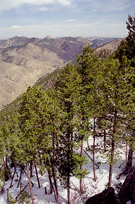 Up
again, and off to the top. We reached the false-summit, which shares a
shallow saddle with the true summit to the south, and my view to the west
was impressive, though spoiled a bit by high, murky clouds. I was well
above Buck Ridge, Kelly Flat and Sheep Mt, and I could see over to the
Mummy Range and pick out Emmaline Spire. I began to cross the saddle to
the south, then examined the deep snow fields lying in the trees of the
north slope to the summit. Based on that, I decided not to try it. Instead,
my plan was to hike north and cross onto the knife-edge ridge that creates
a very deep bend in the river just west of Mishawaka. The snow was
once again my bane, and even on the relatively flat north-face stretch,
I often sunk to my thighs in wet, heavy snow. I wove my way down around
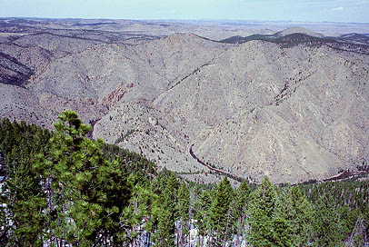
the larger snow patches, and soon found an excellent perch overlooking
the ridge in question. Far below, I could see the single grey thread of
asphalt that is Hwy 14 snake through the canyon, and take a very long detour
to the north around a massive and completely barren ridge of rock, just
as it looks on the map. Mishawaka was hidden for the most part by trees,
but I could see numerous parked cars of their mid-day patrons. The drop-off
from here was considerable, and allowed me to survey the terrain and ascertain
that there was no easy way to get to the ridge from where I was at, considering
that the deep woods stretching down the steep incline would be filled with
impassable snow fields. I decided to abandon the attempt. To the east,
Grey Rock rose up from the surrounding terrain and nowhere have I seen
it look more distinct than from this perch.
Up
again, and off to the top. We reached the false-summit, which shares a
shallow saddle with the true summit to the south, and my view to the west
was impressive, though spoiled a bit by high, murky clouds. I was well
above Buck Ridge, Kelly Flat and Sheep Mt, and I could see over to the
Mummy Range and pick out Emmaline Spire. I began to cross the saddle to
the south, then examined the deep snow fields lying in the trees of the
north slope to the summit. Based on that, I decided not to try it. Instead,
my plan was to hike north and cross onto the knife-edge ridge that creates
a very deep bend in the river just west of Mishawaka. The snow was
once again my bane, and even on the relatively flat north-face stretch,
I often sunk to my thighs in wet, heavy snow. I wove my way down around
the larger snow patches, and soon found an excellent perch overlooking
the ridge in question. Far below, I could see the single grey thread of
asphalt that is Hwy 14 snake through the canyon, and take a very long detour
to the north around a massive and completely barren ridge of rock, just
as it looks on the map. Mishawaka was hidden for the most part by trees,
but I could see numerous parked cars of their mid-day patrons. The drop-off
from here was considerable, and allowed me to survey the terrain and ascertain
that there was no easy way to get to the ridge from where I was at, considering
that the deep woods stretching down the steep incline would be filled with
impassable snow fields. I decided to abandon the attempt. To the east,
Grey Rock rose up from the surrounding terrain and nowhere have I seen
it look more distinct than from this perch.
