
Location: Black Ridge Canyons Wilderness, Colorado Maps: USGS Quad 1:24K Battleship Rock & Mack) Access: I-70 to Fruita Exit south, right on Kings View in 1.5 miles, then 2 miles to the Pollock Bench, Flume and Rattlesnake Canyon trailhead on the left. Fees: None Trail: 7 miles one-way, moderately difficult with steep climbs down and up two significant canyons, requiring passing packs by hand in a couple places. No water except for about 10 minutes after rain. Little shade. Dog Regulations: Vague, I interpret that to mean it's OK until someone complains. I wouldn't take my dog on this trail because it is very rough, with lots of cliffs and there is no reliable water (and my dog drinks a lot of water). Webcam:Tomorrow Hill Farm, Grand Junction Weather:Current & recent conditions National Weather Service Forecast We rolled into Grand Junction around 12, having driven from Cheyenne, WY in around 5.5 hours through superbly beautiful April sunshine. My friend Larry was driving his white Toyota pickup, a weeks worth of camping gear stashed in the bed. Having eaten only a couple of truck-stop donuts on the way out, we were both hungry, and we surrendered to the ruthless fast food marketing and ate at a Burger King. Larry disapproved of his angus beef hamburger, and I cant say my cheeseburger rated anything above necessity food. We ate quickly and drove up the road to the BLM office to pick up whatever brochures might help us get around the area. Larry instantly created for himself a large collection of BLM brochures that will undoubtedly serve valuable reference in the decades to come. Our first stop was
Devils Canyon in the Black Ridge Wilderness. I had been there before,
but had not hiked very much of it. We drove up through Fruita and stopped
at a dead end road just on the northern edge of the wilderness. The sun
was shining brilliantly off the orange sand. Recent record rainfall had
all the desert ephemerals blooming, with thousands of bees humming about
from flower to flower. We set off on the trail trying to distance ourselves
from a large and noisy group, eventually stopping to let them get far in
front before continuing. The area was relatively flat, with grasses and
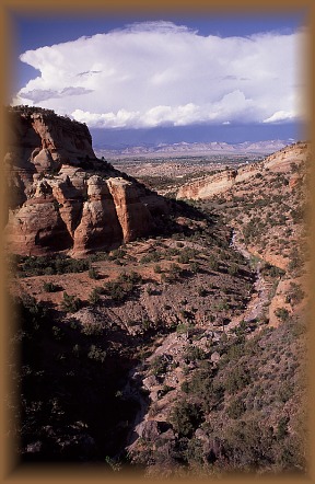
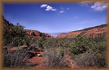
small shrubs dominating the view. Off to the south, however, lay the yawning
chasm of Devils Canyon. The trail was wide and graveled, but we soon left
the main highway for a single track through dense foliage that ran beside
a creek. Globemallow and scarlet gilia bloomed on both sides of the trail
in cheery colors. Perhaps on only 10 days a year does water actively flow
through this sandy wash, and we had hit one of those days. Brown water
like chocolate milk sluiced around boulders and over shelves in the sandstone,
drawn magnetically to the Colorado River, only a mile or two away. We followed
this watercourse along its sandy banks and enjoyed the dichotomy of water
in the desert. Down the trail, close enough that we werent yet bored with
the water but far enough that wed had enough to satisfy us for awhile,
the trail split at the mouth of the canyon. I had hiked with Andra up the
western side a couple of years ago, and it was time to hike on the eastern
side. Steeply, the trail led away from the water and brought into view
the length of the canyon to the south. The thin trail wound through juniper
and pinyon and passed by a surprising number of ant mounds. Around this
time, dark clouds rolled in from the SW and I fretted for my camera, which
I had brought no cover for. The wind blew, and it looked threatening, but
the clouds passed us over, whatever rain dropping out of them evaporating
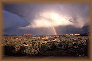
a We drove west to Rabbit Valley looking for a campsite. All three official campsites were full, so we parked the truck along the road and set up in a nice spot overlooking the Colorado River. Larry cooked hamburgers on a tiny hibachi, and I ate two of them. Delicious. The evening was calm and serene. Distant rains threw rainbows across the orange rock landscape, and the dark blue sky made the rock glow in the evening sunlight. I set up my tent about 30 yards from the truck and went to bed just about the time the stars came out. The next day I got up at around 7, just when the sun started heating up my tent. I engaged in the peculiarly satisfying feeling of packing up my gear always nice to see so much useful stuff pack down into such a tiny space. After that I took a walk around the area, noting the large number of bones lying around. When I got back, Larry was up and packed. We took a short walk down a draw to a cliff over the Colorado River. A train track ran below us about 100 yards. The river ran right next to it.
The trail on Pollack
Bench is wide for the first mile heading SW, then narrows abruptly when
it branches off toward Flume Canyon. We took the west branch that leads
to Rattlesnake Arches. We were fortunate to have another fine hiking day.
The sun was unimpeded as we walked along, watching our shadows ripple across
the gravel and rock We continued on west,
uphill, until we reached the junction of the Rattlesnake Arches trail.
Backtracking, we found a wonderful campsite hidden in the pinyon pines
far off the trail. Nearby, we were lucky enough to find a plunge pool full
of cloudy but great tasting water. After setting up camp, we heated up
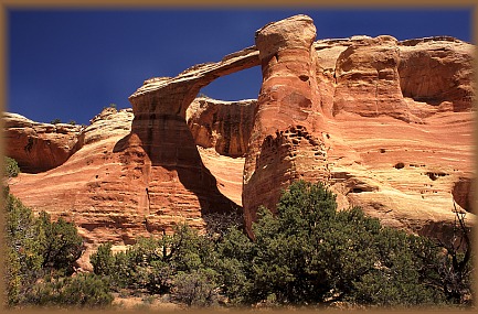
water to make dinner with, and ate a During the night, I wished mightily that I had brought a thicker sleeping bag. The heat from the day evaporated into the starlit blackness of space, leaving the ground frigid, and my toes numb. I was very pleased when dawn arrived. We set off almost immediately for the arches. Not having studied the map very well, we labored under the mistaken impression that the trail by the arches formed a loop. In one sense it does: you can see one end of the trail from the other. However, one must have climbing equipment to make the loop complete. We initially took the high road that looks down upon the southernmost arch, which is one of the more complete and traditional looking arches of the area. Larry hopped down to the next lower rim and walked along to the NW, while I stayed on the upper rim. I lost any sense of a trail, and finally consulted the map to learn that we needed to hike all the way around to the north to get below the arches. So, we did. We backtracked up
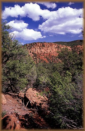
towards camp, then took the north trail that followed the east side of
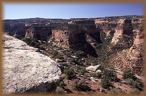
the ridge. Arches lined the west side of the ridge. Shortly, we cornered
the ridge and started down the west side. For the next mile or so, arches
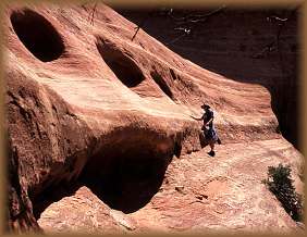
of varying shapes lined the wall. The first one we came upon was an overhang
looking more like a cave than an arch. It slipped back into the cliff,
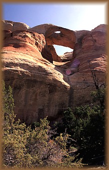
narrowing as the floor sloped up toward the overhang. Near the back of Arches down the trail were more traditional, allowing a significantly larger amount of sky to be seen from below. The sun continued to shine brightly, but the day did not grow hot. We walked along the trail very slowly, photographing the more brilliant features of an extraordinary place. We encountered one man from Denver walking down who was attempting to make the entire trip a day hike. He was from Denver and described to us his Hiking Holiday. I love hiking holidays. I was glad we had come with tents, however. No need to rush things. To the west of this impressive display of arches was yet another. While the arches were standing above us, Rattlesnake Canyon was opening up in a giant fissure below us. Hundreds of layers of multi-colored rock dotted by pinyon and juniper stair-stepped down to the creek bed far below, which appeared to be running. We both agreed a hike up Rattlensnake Canyon would be a fun thing to try, and I met a guy later in the summer who has done it. We recognized the
final arch when we arrived, for we had seen it already from below. Inspecting
the rock surface, we confirmed that we could not reach the trail above
without climbing equipment. So, turning back, we admired all the arches
once again as we walked past them searching for a suitable lunchroom. We
found a nice shady spot in In the late afternoon we cooked dinner (term used loosely boiled water and added to shapeless powdered forms to make instant gruel), then took a short hike east to a small keyhole arch we had seen from the hike the day before. This arch was formed from a large sandstone fin that had been eroded only the very center, to form a small hear-shaped opening. There was no trail up to it, and we I took great pains to avoid crushing the cryptobiotic soil that had grown to impressive cones and peaks all over the sandy desert ledges. The late day sun really lit up the orange rock, and it glowed brightly against the dark eastern sky. From there we followed a side canyon upstream until it boxed up. Larry attempted to climb up higher in the box end but slid down on the smooth rock, breaking his fall with me. No injuries. We hiked back to camp around dark. I put the rainfly on my tent to try to keep the heat in. I also slept fully clothed. That helped, but I was still chilled by morning. 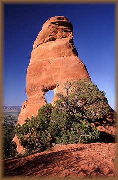 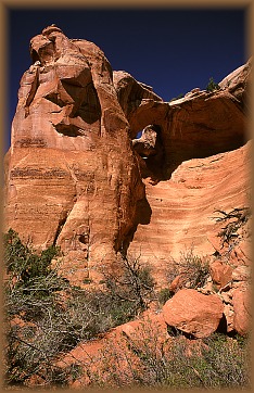
More images of Rattlesnake Arches can be found in the Colorado gallery at LandscapeImagery.com |
 thousand
feet up. Within 20 minutes, the sky was blue again and stayed that way
for the rest of the day. The upland trail was enjoyable, but the call of
the water proved too great, and soon we were back in the canyon bottom,
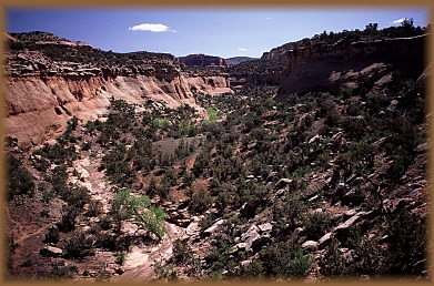
following the gurgling water stream back down the canyon. The canyon
was shaded in places, with steep walls that often rose away at an angle
that would make escape impossible. Giant globemallows dotted the creek
bank with a profusion of orange. I tried to take photographs of the creek
and the vegetation, but my efforts were hampered by the fact that I had
left my tripod at the truck. Nevertheless, I captured enough scenes to
let me remember the place 50 years from now, I hope. As Larry sometimes
says, A mind is a terrible thing. Around each bend the water was up to
something different, sometimes rolling placidly in a wide current, sometimes
riffling over gravel, sometimes swishing around giant boulders, and sometimes,
as in the case of the final bend we were able to explore, dropping off
30 feet to stones below. I admired the drop for some time, holding on to
the rocks near the edge of the drop. A log had gotten wedged in the chute
created by the water, and over time had worn itself into the rock on both
ends, poking into stone like a toothpick. This phenomenon seems to occur
with surprising regularity in the desert canyonlands. In this area, particularly,
we admired a medium-sized shrub with bright white flowers that had 4 petals
that were all thin at
thousand
feet up. Within 20 minutes, the sky was blue again and stayed that way
for the rest of the day. The upland trail was enjoyable, but the call of
the water proved too great, and soon we were back in the canyon bottom,
following the gurgling water stream back down the canyon. The canyon
was shaded in places, with steep walls that often rose away at an angle
that would make escape impossible. Giant globemallows dotted the creek
bank with a profusion of orange. I tried to take photographs of the creek
and the vegetation, but my efforts were hampered by the fact that I had
left my tripod at the truck. Nevertheless, I captured enough scenes to
let me remember the place 50 years from now, I hope. As Larry sometimes
says, A mind is a terrible thing. Around each bend the water was up to
something different, sometimes rolling placidly in a wide current, sometimes
riffling over gravel, sometimes swishing around giant boulders, and sometimes,
as in the case of the final bend we were able to explore, dropping off
30 feet to stones below. I admired the drop for some time, holding on to
the rocks near the edge of the drop. A log had gotten wedged in the chute
created by the water, and over time had worn itself into the rock on both
ends, poking into stone like a toothpick. This phenomenon seems to occur
with surprising regularity in the desert canyonlands. In this area, particularly,
we admired a medium-sized shrub with bright white flowers that had 4 petals
that were all thin at 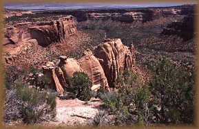 the
base, then widening as they radiated out. Later we identified this shrub
as Fendlerbush. We scrambled up a steep slope to escape the depth of the
canyon, and found ourselves right back near the trail in the juniper that
we had passed by an hour or two before. We hiked out the way we had come
in.
the
base, then widening as they radiated out. Later we identified this shrub
as Fendlerbush. We scrambled up a steep slope to escape the depth of the
canyon, and found ourselves right back near the trail in the juniper that
we had passed by an hour or two before. We hiked out the way we had come
in.
 We
hopped in the Toyota and cruised over to Colorado National Monument, which
we had to drive through to get to the south side of the wilderness. The
monument is entertaining. My only complaint is that its too small. No
one at the visitors center seemed to know if the Black Ridge Rd was open,
so we drove all the way down there to find out that it wasnt. A victim
of record rainfall, the rough road was closed to prevent damage. This was
Sunday, so we assumed nobody would be out to check it today. Thus, we scrapped
our meticulously-made plans for backpacking Mee Canyon and drove back around
the north side and parked at the Pollack Bench Trailhead. This too was
familiar as Andra, the dogs and I had hiked on this trail as well in the
past. Being Sunday, the trailhead was hopping. Dogs and people everywhere,
all looking quite pleased to be there. Larry and I did a last minute repack
of our frame packs and snacked on food that we would leave in the truck.
We
hopped in the Toyota and cruised over to Colorado National Monument, which
we had to drive through to get to the south side of the wilderness. The
monument is entertaining. My only complaint is that its too small. No
one at the visitors center seemed to know if the Black Ridge Rd was open,
so we drove all the way down there to find out that it wasnt. A victim
of record rainfall, the rough road was closed to prevent damage. This was
Sunday, so we assumed nobody would be out to check it today. Thus, we scrapped
our meticulously-made plans for backpacking Mee Canyon and drove back around
the north side and parked at the Pollack Bench Trailhead. This too was
familiar as Andra, the dogs and I had hiked on this trail as well in the
past. Being Sunday, the trailhead was hopping. Dogs and people everywhere,
all looking quite pleased to be there. Larry and I did a last minute repack
of our frame packs and snacked on food that we would leave in the truck.
 of
the trail. Blue skies highlighted the orange rock. Primrose and prickly
pear bloomed on all sides. We passed an especially interesting bladderpod
milkvetch that looked like it came from another planet. White longleaf
phlox, white and yellow Townsendia, yellow eye cryptantha and dwarf evening
primrose rounded out the floral arrangement. The trail itself isnt very
long, but it crosses two major canyons on its way to Rattlesnake Canyon,
making for a strenuous hike. I noted the spot where Andra and I had turned
back on the last trip, stymied by dogs that were drinking all our water
too quickly and not slowing down to cool off. Larry and I cruised past
that point, and hiked into the bottom of the canyon, then upstream along
a trickling water course, and back up the other side. The second canyon
we came upon required us to remove packs, and pass them by hand up the
steep climb. Bladderpod plants with characteristic swollen seed pods dotted
the area.
of
the trail. Blue skies highlighted the orange rock. Primrose and prickly
pear bloomed on all sides. We passed an especially interesting bladderpod
milkvetch that looked like it came from another planet. White longleaf
phlox, white and yellow Townsendia, yellow eye cryptantha and dwarf evening
primrose rounded out the floral arrangement. The trail itself isnt very
long, but it crosses two major canyons on its way to Rattlesnake Canyon,
making for a strenuous hike. I noted the spot where Andra and I had turned
back on the last trip, stymied by dogs that were drinking all our water
too quickly and not slowing down to cool off. Larry and I cruised past
that point, and hiked into the bottom of the canyon, then upstream along
a trickling water course, and back up the other side. The second canyon
we came upon required us to remove packs, and pass them by hand up the
steep climb. Bladderpod plants with characteristic swollen seed pods dotted
the area.
 fine
meal of freeze-dried something or other. I had taken along an Abbey novel,
Black Sun, and I read quite a bit of it that evening. Larry took a hike
up to the ridge above camp, and I strolled downhill to the rim overlooking
a rim overlooking a rim overlooking the Colorado River. Though we were
high up and far from roads, the sound of automobile engines managed to
make it up to us from the interstate far below in the valley. We tried
to ignore it, but it is a fact that the automobile is difficult to escape.
fine
meal of freeze-dried something or other. I had taken along an Abbey novel,
Black Sun, and I read quite a bit of it that evening. Larry took a hike
up to the ridge above camp, and I strolled downhill to the rim overlooking
a rim overlooking a rim overlooking the Colorado River. Though we were
high up and far from roads, the sound of automobile engines managed to
make it up to us from the interstate far below in the valley. We tried
to ignore it, but it is a fact that the automobile is difficult to escape.
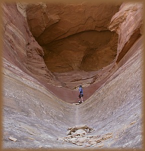 the
gaping opening, a small hole, no more than 4 feet across, led up to the
bench above. We climbed into the lower part of the opening, but the smooth
sandstone proved too steep to climb up to the hole. Playing it safe, neither
of us attempted it.
the
gaping opening, a small hole, no more than 4 feet across, led up to the
bench above. We climbed into the lower part of the opening, but the smooth
sandstone proved too steep to climb up to the hole. Playing it safe, neither
of us attempted it.
 a
shallow alcove between two of the arches. A couple of large pinyons provided
shade. We ate a leisurely lunch before moving on. We followed the trail
without deviation back to camp, and decided to relax for a bit. I found
a smooth bed of sandstone under a juniper and read my book in between short
catnaps. Bees droned from wallflower to wallflower, but there were no gnats
or mosquitoes out.
a
shallow alcove between two of the arches. A couple of large pinyons provided
shade. We ate a leisurely lunch before moving on. We followed the trail
without deviation back to camp, and decided to relax for a bit. I found
a smooth bed of sandstone under a juniper and read my book in between short
catnaps. Bees droned from wallflower to wallflower, but there were no gnats
or mosquitoes out.
 We
drove SE to Big Dominguez Creek, and hiked along the canyon trail there.
Red rocks and barren understory under pinyon pines rolled on and on in
a fairly monotonous landscape. The canyon was wide and open, with a good-sized
creek running in the middle. Beaver dams in places backed up the water
and created still pools from which Im sure mosquitoes breed by the millions.
We hiked perhaps 4 miles total before setting up camp in a pleasant little
camp site right next to the creek. We cooked dinner and ate at the picnic
table and then retired to our tents. I slept very well that night thanks
to my heavier tent and the addition of my sleeping bag liner. Very cozy.
Clouds rolled in during the night and we woke up to a soupy sky. After
4 days of camping, we decided to forgo further exploration of Big Dominguez
and return home...have to go back and explore more of Big Dominguez someday.
I snacked on items for breakfast before we left for Cheyenne.
We
drove SE to Big Dominguez Creek, and hiked along the canyon trail there.
Red rocks and barren understory under pinyon pines rolled on and on in
a fairly monotonous landscape. The canyon was wide and open, with a good-sized
creek running in the middle. Beaver dams in places backed up the water
and created still pools from which Im sure mosquitoes breed by the millions.
We hiked perhaps 4 miles total before setting up camp in a pleasant little
camp site right next to the creek. We cooked dinner and ate at the picnic
table and then retired to our tents. I slept very well that night thanks
to my heavier tent and the addition of my sleeping bag liner. Very cozy.
Clouds rolled in during the night and we woke up to a soupy sky. After
4 days of camping, we decided to forgo further exploration of Big Dominguez
and return home...have to go back and explore more of Big Dominguez someday.
I snacked on items for breakfast before we left for Cheyenne.
 Big
Dominguez Canyon
Big
Dominguez Canyon
 |
|