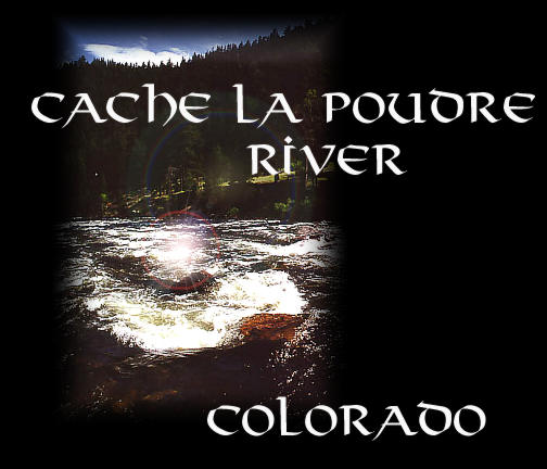
| Location: Northern Colorado,
just northwest of Fort Collins. Highway 14 runs along the Poudre River
for much of its length.
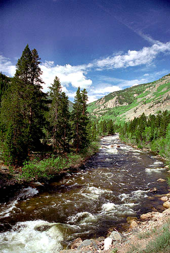
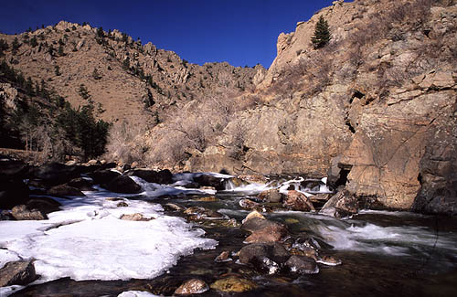
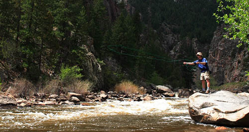
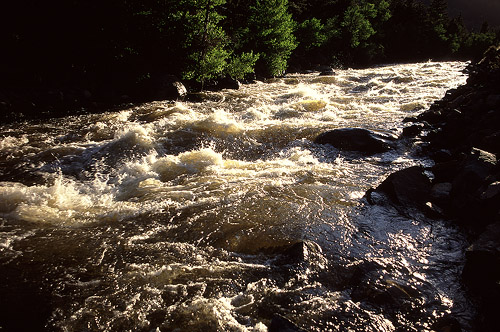
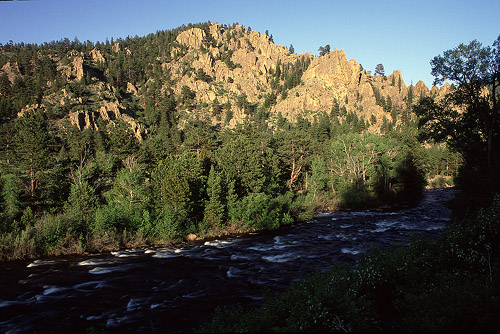
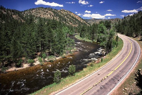
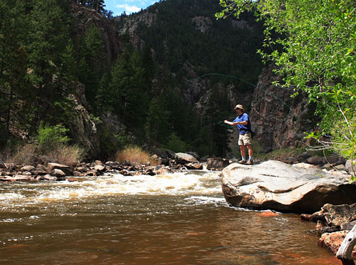
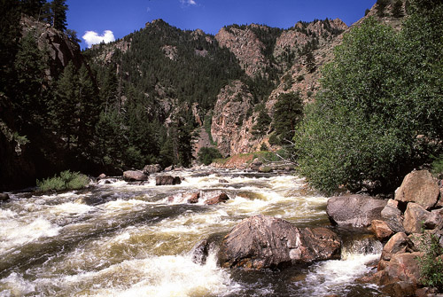
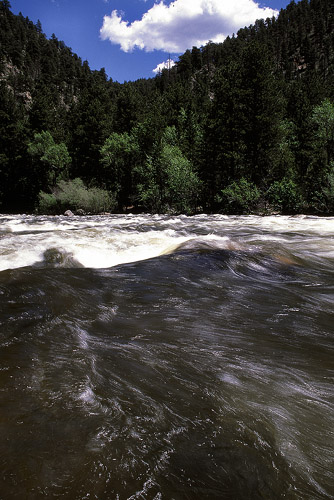
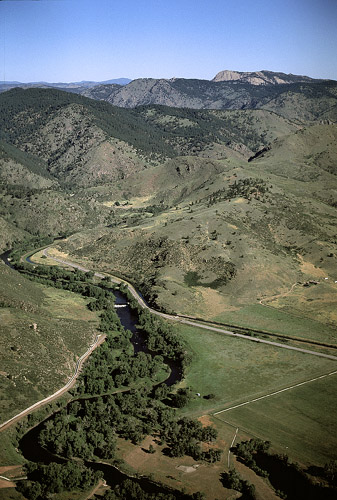
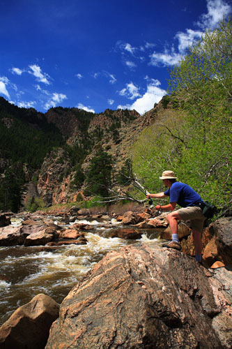
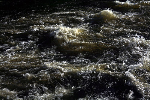
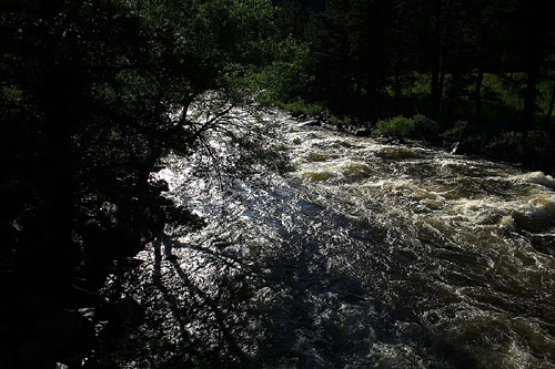
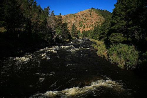
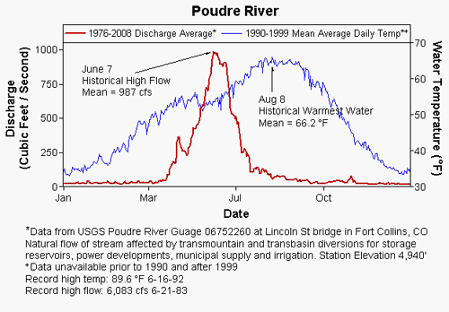
Access: From Fort Collins, take Hwy 287/14 north of Fort Collins to the split at Ted's Place, and follow Hwy 14 west. Maps: Trails Illustrated #112: Poudre River/Cameron Pass (with a great photo on the front!) Trails Illusrated #101: Cache La Poudre/Big Thompson USGS 7.5' Poudre Park USGS 7.5' Big Narrows USGS 7.5' Rustic USGS 7.5' Kinikinik USGS 7.5' Boston Peak USGS 7.5' Chambers Lake Fishing: The Poudre has both natural fisheries and stocked areas. Some of the river is articial lure only. Pullouts along the highway provide access. The Cache la Poudre River (French for "powder store"), according to hydrologists who carefully study the issue, begins in Poudre Lake just east of the Continnetal Divide at Milner Pass in Rocky Mountain National Park. The water flows north into Roosevelt National Forest, picking up numerous creeks and seasonal trickles as it progresses. The path of the river is hidden from view by immense tracts of lodgepole pine, dark blue spruce, nimble subalpine fir and airy stands of fluttering aspen that spend more than half the year under a deep blanket of snow. After 30 miles, the current veers around to the east and begins coursing through a deep canyon. Near this turning point lies the Big South trailhead, starting at the junction of the river and State Hwy 14. For the next 40 miles it charges downhill through narrow gorges and wide, smooth-surface glens, all the while closely bordered by a narrow, windy road. Along its sprint to the plains it passes by Profile Rock and Sleeping Elephant, through the sinewy curves of The Narrows, past Grey Rock and Red Mountain, fed during the springtime by Young Gulch, Stevens Gulch, Dadd Gulch, Roaring Creek, Hewlett Gulch and the hidden mouth of the South Fork that drains the Pingree Park area. As it descends, the subalpine forest gives way to open stands of red-trunked Ponderosa on northern slopes, and cactus, wheatgrass and juniper on the southern slopes where the sun bakes away moisture in the long summer days. In the springtime the river flows with a heavy volume that tapers off in July and becomes only a trickle, not even deep enough to float a raft on, by September. Ive rafted the river twice, once in a wet year and once in a dry. In an average year, the Poudre River carries 288,000 acre feet of water (an acre foot equals about 326,000 gallons). During the dust bowl years it carried an average of 120,000 acre feet. In 2002 it carried only 89,000 acre feet, which was about 30% normal flow. WOW! What a drought! In drought years, especially 2002, the water that finally reaches the mouth of the canyon is only centimeters deep and a few feet wide. Of course, thats after the numerous municipal "water-improvement" projects upstream that divert and trap water for the civilization on yonder parched and plowed plains. A spiders web of irrigation canals and ditches, most larger than the natural river, criss-cross the area with glamorous names like Greeley No.2 and Eaton Canal, and feed the hundreds of stagnant reservoirs that rise and fall several feet every year as farmers pour water on their fields of corn and onions. Over 90% of the water in the Poudre River basin is used for agriculture. Looking at a map, I found it difficult to discern the path of the river amidst the man-made canals and ditches. There have been proposals off and on over the last decade to expand Halligan Reservoir on the North Fork of the Poudre from 6400 acre feet to 40,000 acre feet (600% increase) at a financial cost of $30 million, to expand Seaman Reservoir on the North Fork, and to create Glade Reservoir, a 220,000 acre foot, $200 million basin that would require the rerouting of State Hwy 287 north of Fort Collins from Ted's Place to Owl Canyon near Laramie. Naturally not everyone is thrilled with these proposals. The people floating these proposals don't recognize that water holding capacity in the region already outstrips water availability from rain and snowmelt. How often in the last twenty years has Horsetooth Reservoir been full? Building more dams will not magically make it snow more, so you're left with more bathtub-ringed reservoirs. Too many people wanting too much from a humble river, and yes, I'll take my fair share of blame for living a few years in this watershed and watering my lawn while I did. Yet all is not lost. It will continue to rain, we hope, and conservation has a real chance to reduce our needs and wants on the river, and perhaps find a way to leave a nice amount for all the rest of the thirsty critters that try to make a living amongst the burgeouning northern Colorado suburban utopia. What is left of the river when it joins the South Platte just east of Greeley, CO flows off over the eastern horizon of yellow hayfields and corn megamonocultures and out of my own personal interest. It is principally those portions of the river lined with conifers that I find interst in. Fishing is a wonderful activity to pass through a hot summer day with. I am privileged to have spent many hours on various stretches of the river pulling in rainbow and brook trout, occasionally a brown, large and small. I tried for two years fishing the river with spinners and a cast reel, with no success. Then I decided to emulate the fly fisherman with their standard issue tan vest and brown chest waders and I found that trout go silly for flies floating on the water. I have never gotten my tan vest, or used my brown waders, but have still managed to catch a load or two of fish. Among my favorite memories of long summer days are those when the sun rose over my shoulder as I sought that perfect fishing hole. For hours I would cast the line in with a sharp wrist jerk, let the fly ride the riffles downstream and into the deep calm and beyond, then pull it out sharply and launch it back in upstream. I must admit it took me several years of practice to get to the point where I could cast the fly just about as far as I ever needed to. Ive never studied the technical manuals, so I dont know how to do the fancy casts and I still get hung up in grass on a steep bank or overhanging willows quite alot. No matter. The casting in itself is relaxing and fun. Flies are cheap and time is ample during those long days, and I rarely feel pressed for time as I use a stick to bend down a willow branch to get untangled. The only thing I watch out for with earnest are rattlesnakes. I concentrate particularly hard on them near the lower end of the canyon, where the tall grass dries out early in the summer and the hot baked soil looks just like the brown and grey patterned back of a timber rattler. Once, when I was forced to climb high up on the steep river bank to get around a large cliff face that fell into the water, I was so worried about them that at every step I called out nonsensical phrases in a loud voice to scare them off. I have never yet been confronted by one along the river. My favorite day fishing was in late June when I arrived along a promising-looking stretch of water before sunrise. It was a cool, damp morning with a clear blue sky, and the water was an inky black in the shadow of the canyon walls. The area I was in had steep grassy banks that led down to a rocky shore, beyond which the water swirled and plunged in and around dozens of gigantic boulders peeking their smooth white heads out of the water. I fished from the left bank to begin with, and quickly caught a medium-sized rainbow in the lee side of one such boulder. I unhooked him and placed him gently back in the water, holding him toward the gentle bankside current until he suddenly woke up and darted off under the rock. The sun came up and hit the water with a yellow gleam, and I bent low as I stalked the bank to avoid casting a shadow on the water. I staked out a small 1' waterfall that proved to be a great find. I pulled in 3 fish from the undertow of that fall. I continued on and was attempting to get into the middle of the river by rockhopping when I slipped in up to my knee. Now, had I crossed straight through the water upstream where it is calm, I wouldve only wet my ankles and no more. But, trying to jump across the narrow channel where the water was deep led to me getting my entire leg wet. I decided what the heck and plunged my other leg in up to the knee and slogged across. The water was very cold at first, but I got used to it. As the sun climbed higher, I began to appreciate it, then even crave it. I soon found myself dragging a hand in the water, then splashing it over my perspiring forehead. I waded from shallow to shallow, bank to bank, casting as I went, and careful not to let the line get caught in an undertow. The sun glazed overhead like a quiet spectator. Now and then I would pull in a fish out of an area that seemed completely devoid of fish. Other times I would fish likely places for half an hour and not get anything. As morning wore on, I stuck to the shaded right bank of the river and tried to avoid tree limbs. I got hooked twice on pine limbs, and had to scramble up the steep bank to reach them and bend them to where I could unhook. Once I simply had to cut the line. I dont recall how many fish I caught, but it was enough to keep me perpetually interested all morning and most of the afternoon. Towards 2 oclock, the wind picked up and blew up the canyon strongly, glazing the water in millions of tiny ripples that obscured the view of the deep water and made casting almost impossible. I called it in and went home. I should have more days like that. The Poudre River, although developed quite a lot, is still relatively wild compared to many other Colorado Rivers. I often think of its closest cousin, the Big Thompson River, which flows out of Rocky Mountain National Park, through the towns of Estes Park and Loveland and into the South Platte. This river also runs through a deep canyon, even deeper than the Poudres, and is just as naturally spectacular. The unfortunate thing is that the tremendous tourism drawn up the canyon by the lure of the National Park has led to significantly more development, primarily of souvenir stands selling cherry cider and carved bears to set on ones front porch in greeting. Houses and cabins stand in rows behind the shops and parking lots on either side of the highway that parallels the river for much of its length through the canyon. Thousands of people drive the road. There are few places along the entire stretch of road from Loveland to Rocky Mountain National Park where one could have a decent, quiet time hiking or fishing near the river. So, comparatively, the Poudre is still a gem. Last year in Colorado several state congressional leaders proposed reactionary legislation that sought to solve Colorados problem of record-low snowpack by damming more rivers, as if having more empty reservoirs than the state already has would somehow induce the gods to send more snow our way. Would damming the Poudre have been a possibility under that new proposition? I dont know. It was mercifully defeated in the Senate. I wouldnt put it past some of those politicians to try it. Where most people see a beautiful free-flowing river coursing down pine-covered hills and canyon walls, politicians seem only to see dollar signs. I think its a disease. It's in the water they drink up at the capitol. There's rumblimg of damming the Poudre even now, just below the mouth of the canyon. Ive spent lots of days hiking straight off the highway up the steep canyon walls and peaks on either side of the river. I think most people would be surprised how steep a slope one can walk up without climbing equipment. Whenever I scramble up some of those canyon walls using all four limbs and stop after 10 minutes to look down and see mostly only the TOP of my car below, I too am surprised. Of course, going up is the easy part, as everyone knows. I got into a nice groove of exploring the rough trail-less canyon terrain in 2001, spending many hours tracking ever-upward away from the river. The funny thing was that I never was able to get to anything that I could call "the top". Any peak one sees from the road turns out only to be an outcropping of a mountain three times as high, but out of view from the river. When you get to the top of THAT mountain, you find it is but a swell at the foot of a much larger mountain beyond. Really doesn't matter, though. Hiking and seeing and being there is the real goal, not the top, wherever it may be hiding. There are plenty of bighorn sheep to be seen by the quiet hiker. Several years ago I was driving down the canyon when I spotted two of them perched on a rock outcropping on the north side of the road. I pulled the car over and snapped a couple of photos, then trotted up the hill with my camera and around the back of the outcropping. When I got to the top, they were completely out of sight. They just vanished. On another occasion Frank spotted a couple of young rams as he and I passed a lazy afternoon in a grove of limber pine high up a rocky slope commanding a view for several miles along the river. He growled to herald their approach, and I saw that the game trail they were following would take them right next to us. I decided to let them pass without interference and we left the shaded grove and stepped into the garish afternoon sun in the boulder field. The two rams halted and watched intently for a few moments as Frank and I slowly picked our way down through the boulders and loose tallus. The two rams then started to walk again, straight toward us (faster than before?) and Frank never took his eyes off them, growling just loudly enough to let me know he was aware of them. As we made our way down with labor, the rams made their way over with ease, and the gap was narrowing between us all the while. Frankly, I was a bit worried for a touch there, but they didn't descend when they got to the pine grove, but instead just stood and watched. Curious? Never did get close enough to discover their true intentions, perhaps for the best. Ive always been on the lookout for mountain lions, hoping to see one in its native state. Never have. I hear theyre around. Maybe someday. Through imprinting during some forgotten summer day, I associate driving in the Poudre Canyon with Bob Segar hits. Just about every place I've gone becomes associated with a particular song or artist. This canyon just seems to be a Bob Segar kind of canyon. For awhile there I owned a Saturn with a sunroof, and really there was no better driving on earth than to cruise up that canyon (never down, because that would be heading the wrong way) with the top down, the windows open and Bob Segar repeating his refrain again and again and again, "Against the wind....Against the wind....Against the wind..." Thinking about it now, I can almost smell the river.
|
 |
 |
 |

Page created 12-13-02
Updated 84-26-15
Comments