Pot Creek
Location: NAD83 zone 12
671786e 4497465n Elev: 5500'
The first vegetation-monitoring site
I did on my own was at Pot Creek in early June. My first partner had quit
only days into the job to take a permanent position in Michigan, and my
second partner had only been able to work until summer classes began, which
they had. No new person had come on yet. Thus, I drove out west to Pot
Creek alone, but I didnt mind at all.
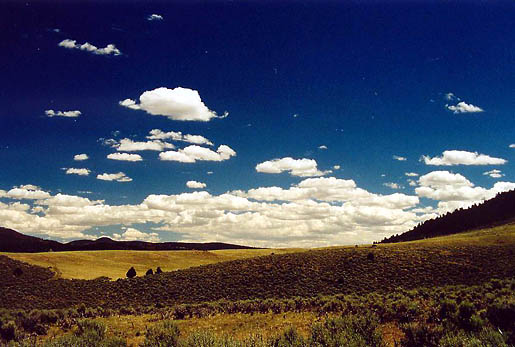
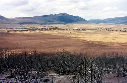
I was fifteen miles from the nearest
pavement, out in the sage-grass flats interrupted by fir-crowned mountains
on the western side of the Green River. The hulking Dodge pickup bounced
along the rocky two-track sending a smooth plume of fine grid skyward for
a mile back. I blared the radio, I think CCR, and sang along, AC on high.
Id open the windows, but the dust coasts everything if you do that. By
the time I found my way through the maze of two tracks, the sun was high
overhead, and puffy white clouds had sprung up mysteriously all around,
like gobs of shaving cream dropped on a glass counter. The lock on the
gate leading to this section of the park would not permit itself to be
opened by the only park key I had, so I simply used a piece of dry sagebrush
to hold apart the top two wires of the fence so I could squeeze through,
although I did pluck a hole in the seat of my jeans via this act. The sky
was a silent witness as my boots crunched gravel and last years grass as
I made my way through the labyrinth of waist-high blue-green sagebrush,
Artimesia
tridentata, toward a point known as N060408 E447942, or something to
that effect. After much sleuthing with the aid of my PLUGR GPS unit, I 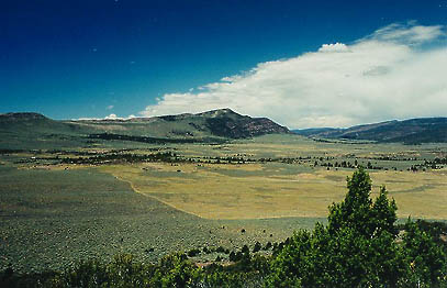 found
the 10 inch T-post cleverly hidden next to a sagebrush trunk, rusted to
the same color and looking very much like a native species. I flagged it,
then punched in the coordinates for its better half (the end post) and
found it in like manner. Then I tramped all over the field, ranging up
to a mile, finding all 10 posts for the five transects, like some wilderness
Easter egg hunt. After the posts were marked, I gathered the optical point
projection device, a tape measure, a clipboard and a fanny pack with a
water bottle and my radio. The optical point projection device, or OPPD,
as government agencies, fond of acronyms to a fault, like to call it, is
essentially a periscope, 1/2-m long, mounted horizontally on a tripod 5-ft
tall so as to allow the observation of the ground through a magnifying
lens. In this way, a well-trained botanist or seasonal scrub like myself
can ID plants without leaving the relative comfort of the standing position.
I laid out the tape measure between the first pair of posts, 100-m apart,
and pulled it taught. Then I zipped along the transect, identifying whatever
the scope crosshairs centered on, 2 points/meter (one on either side of
the tape measure). If it was bare ground, I would check that column, rock
or litter, a check for those columns. Plants were identified to the species
level. The area I was in was the control (unburned) area so sagebrush was
the dominant plant. After I had finished found
the 10 inch T-post cleverly hidden next to a sagebrush trunk, rusted to
the same color and looking very much like a native species. I flagged it,
then punched in the coordinates for its better half (the end post) and
found it in like manner. Then I tramped all over the field, ranging up
to a mile, finding all 10 posts for the five transects, like some wilderness
Easter egg hunt. After the posts were marked, I gathered the optical point
projection device, a tape measure, a clipboard and a fanny pack with a
water bottle and my radio. The optical point projection device, or OPPD,
as government agencies, fond of acronyms to a fault, like to call it, is
essentially a periscope, 1/2-m long, mounted horizontally on a tripod 5-ft
tall so as to allow the observation of the ground through a magnifying
lens. In this way, a well-trained botanist or seasonal scrub like myself
can ID plants without leaving the relative comfort of the standing position.
I laid out the tape measure between the first pair of posts, 100-m apart,
and pulled it taught. Then I zipped along the transect, identifying whatever
the scope crosshairs centered on, 2 points/meter (one on either side of
the tape measure). If it was bare ground, I would check that column, rock
or litter, a check for those columns. Plants were identified to the species
level. The area I was in was the control (unburned) area so sagebrush was
the dominant plant. After I had finished 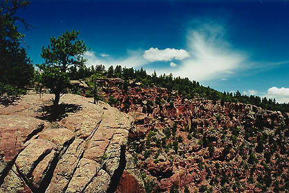 with
that transect, I moved on to the next, then the next. The silence of the
place was broken occasionally by the chirps of birds or the crackled choices
on the shortwave radio. I could listen, but the ridge to the east meant
I couldnt call in. Didnt need to. I finished all the control transects,
then sat in the afternoon shadow of the truck's camper shell to eat my
lunch. Fresh fruit was the food of choice, undoubtedly craved by the body
for its water content. I scarfed down all the food, and refilled my canteen
with warm water from the five-gallon jug I had placed underneath the truck
to keep it cool. with
that transect, I moved on to the next, then the next. The silence of the
place was broken occasionally by the chirps of birds or the crackled choices
on the shortwave radio. I could listen, but the ridge to the east meant
I couldnt call in. Didnt need to. I finished all the control transects,
then sat in the afternoon shadow of the truck's camper shell to eat my
lunch. Fresh fruit was the food of choice, undoubtedly craved by the body
for its water content. I scarfed down all the food, and refilled my canteen
with warm water from the five-gallon jug I had placed underneath the truck
to keep it cool.
I repeated the five-transect pattern
in the area that had burned last year, such that the sagebrush was missing
and replaced with a lush grass intermingled with pink phlox and white and
yellow Erigeron. The breeze picked up, which was welcome in the heat of
the afternoon. The transects went quickly as I daydreamed, and I was done
well before sunset. I packed up the truck and drove it back down the road,
then over towards the canyon rim to a group of large red rocks covered
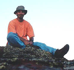
with Ponderosa Pine and heapings of duff. After looking around a bit, I
found what I considered to be the primo tent spot of 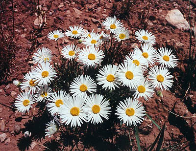 the
area and began unpacking my extensive collection of government camping
gear. I set up camp and then sat in the shade of the rocks and read, often
stopping to look around at the scenery. As the sun set, the heat was lost
to space, and the rocks became chilly to touch. I put on a sweatshirt and
took my camera with me up to the highest rock to watch the sunset. I watched
the last light fade from the sun setting behind Wild Mountain, but no dazzling
burning sunset ever appeared. Some nights are like that. I used my coal-miner
lamp to read on into the night, well beyond the point when the stars came
out. Good rest on the soft pine needles. the
area and began unpacking my extensive collection of government camping
gear. I set up camp and then sat in the shade of the rocks and read, often
stopping to look around at the scenery. As the sun set, the heat was lost
to space, and the rocks became chilly to touch. I put on a sweatshirt and
took my camera with me up to the highest rock to watch the sunset. I watched
the last light fade from the sun setting behind Wild Mountain, but no dazzling
burning sunset ever appeared. Some nights are like that. I used my coal-miner
lamp to read on into the night, well beyond the point when the stars came
out. Good rest on the soft pine needles.
The next morning I got up at 4:30 in
hopes of catching the sunrise and I just beat it to my observation rock.
I enjoyed the suns rise even more than its departure the evening before.
I watched the western hills grow orange, and the shadows recede down the
cold rock. The sky was as blue as a painting, surreal at that, with a blacklit
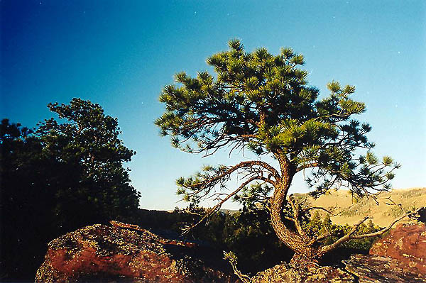
electric glow. I took photographs of the intriguing Ponderosas, twisting
their way up through giant fissures in the rocks, their needles orange
in the morning light.
 I
sat in the still morning and gradually movement stirred in the form of
birds, insects, hares and an occasional hint of a breeze. After the full
splendor of morning was upon me, I strode back to camp and had an instant
oatmeal breakfast. After that, I took a long hike over the ridge between
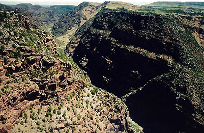
the burn site and the Green River so that I actually came upon the Hell's
Half Mile portion of the Canyon of Lodore. Deep in the rock canyon lay
a thin strip of green, sparkling in the sun: the Green River, or at least
a dam-flow-controlled trickle occupying the canyon carved by the Green
River. I hopped around the rocks and fallen trees to get right to the edge,
and there, ate a grapefruit while watching the river roll 2000 feet below.
I would pass under this rock in three more months. I
sat in the still morning and gradually movement stirred in the form of
birds, insects, hares and an occasional hint of a breeze. After the full
splendor of morning was upon me, I strode back to camp and had an instant
oatmeal breakfast. After that, I took a long hike over the ridge between
the burn site and the Green River so that I actually came upon the Hell's
Half Mile portion of the Canyon of Lodore. Deep in the rock canyon lay
a thin strip of green, sparkling in the sun: the Green River, or at least
a dam-flow-controlled trickle occupying the canyon carved by the Green
River. I hopped around the rocks and fallen trees to get right to the edge,
and there, ate a grapefruit while watching the river roll 2000 feet below.
I would pass under this rock in three more months.
 I
took a slightly varied route back, crossing the ridge higher up in the
thick pines, then descending through a jungle of curl-leaf mountain mahogany
into the sagebrush, then to the grass, the truck and a nap. I slept in
fine style for an afternoon siesta, bothered by no noise made by humans
(the only noise that disturbs). I made one more trip to the canyon rim,
this time closer to camp, where I ate a late afternoon orange. Birds flew
acrobatics tryouts on the updrafts from the canyon below. I spent the night
at the same spot, and reluctantly left the next morning. The whole place
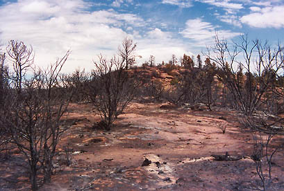
burned three months later by an escaped prescribed fire. I
took a slightly varied route back, crossing the ridge higher up in the
thick pines, then descending through a jungle of curl-leaf mountain mahogany
into the sagebrush, then to the grass, the truck and a nap. I slept in
fine style for an afternoon siesta, bothered by no noise made by humans
(the only noise that disturbs). I made one more trip to the canyon rim,
this time closer to camp, where I ate a late afternoon orange. Birds flew
acrobatics tryouts on the updrafts from the canyon below. I spent the night
at the same spot, and reluctantly left the next morning. The whole place
burned three months later by an escaped prescribed fire.
|