Location:
Dinosaur National Monument, Colorado
Maps:1:78K
National Geographic Trails Illustrated #220 Dinosaur National Monument;
USGS 7.5 Quad: Canyon
of Lodore South
Access:
From Highway 40 near Dinosaur, CO, take the Harpers Corner Rd 23 miles,
then turn east onto the Echo Park Rd which leads down through upper Sand
Canyon and splits just beyond. Take the left fork that goes to Echo Park,
and follow the road all the way. Park in Echo Park, then follow the river
upstream to the confluence with the Yampa, then follow the Yampa less than
a mile to the outlet of Lower Sand Canyon.
Trail:
From
Echo Park, walk upstream along the Green, then upstream along the Yampa
until you come to SandCanyon on the south shore. A little scramble and
knee-deep wade at first is as bad as it gets, the rest of the trail is
a steady uphill grade. Distance: 3 mi one-way, 500 ft elevation gain.
Trailhead
(Echo Park): NAD83 zone 12 670189e 4487410n
Fees:
None, unless camping
Dogs:
Not allowed
Weather:
Recent
Conditions NWS
Pinpoint Forecast
 As
part of our multi-day trip in Dinosaur National Monument, Larry and I rolled
down the road that runs into Echo Park on slick but drying roads. The June
rain that had moved into the area had already delayed our venture down
onto the Yampa Bench by a day, but this morning was sunny and warm, and
proved to be just the kind of day we had been waiting for. We followed
the winding course of Pool Creek through tall canyon walls and giant cottonwoods,
then into the wide open of a nearly-empty Echo Park and chose a campsite
near the river. After a quick unpacking, we shouldered our light
packs and walked east along the dirt road that led to the boat ramp. A
group of rafters was busy at the boat ramp, and we continued walking east
along the Green River until the dirt road became a dirt path that followed
the river as it turned north. The trail led through an open park of grass
dotted with gnarled cottonwoods. Only a few hundred yards to the east lay
the cliffs of Jenny Lind Rock. Just to the west, the water of the Green
River flowed noiselessly along with barely a ripple only a few feet from
the trail. Just beyond the 70-yard-wide river, Steamboat Rock rose straight
up out of the water several hundred feet. As
part of our multi-day trip in Dinosaur National Monument, Larry and I rolled
down the road that runs into Echo Park on slick but drying roads. The June
rain that had moved into the area had already delayed our venture down
onto the Yampa Bench by a day, but this morning was sunny and warm, and
proved to be just the kind of day we had been waiting for. We followed
the winding course of Pool Creek through tall canyon walls and giant cottonwoods,
then into the wide open of a nearly-empty Echo Park and chose a campsite
near the river. After a quick unpacking, we shouldered our light
packs and walked east along the dirt road that led to the boat ramp. A
group of rafters was busy at the boat ramp, and we continued walking east
along the Green River until the dirt road became a dirt path that followed
the river as it turned north. The trail led through an open park of grass
dotted with gnarled cottonwoods. Only a few hundred yards to the east lay
the cliffs of Jenny Lind Rock. Just to the west, the water of the Green
River flowed noiselessly along with barely a ripple only a few feet from
the trail. Just beyond the 70-yard-wide river, Steamboat Rock rose straight
up out of the water several hundred feet.
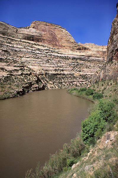
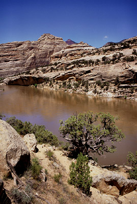
We continued northward
at an unhurried pace, enjoying the warmth of the sun and the calm, quiet
air of the wide canyon. We reached the confluence of the Green and the
Yampa, although the actual water junction was hidden behind a screen of
willows and young tamarisk. Turning west, we followed the trail along the
south bank of the Yampa River, Colorados last undammed-river. Years ago,
I missed a free raft trip down the Yampa when I started work a mere 2 days
after all my coworkers had left for a 4 day-trip. Had I but started a few
days earlier, I couldve gone too, and the Yampa would not be nearly as
much mystery as it is now. The trail rose up high above the water while
clinging to a steep slope at the northern edge of Jenny Lind Rock. It was
very hot in the dry air, and we stopped when we finally reached meager
shade to rest and drink water. Continuing on, the trail dipped down close
to the water, and then dipped into a tree-filled crack in the wall that
was the mouth of Sand Canyon.
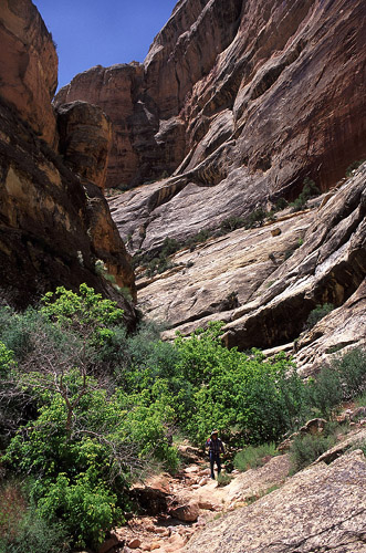
 In
the dark of the thin canyon, it was much cooler, with a scent of wet earth
that was both refreshing and energizing. We walked up canyon to the first
obstacle: a pool of water that could not be circumvented. Larry went up
first, donning his watersocks. As I had no watersocks, I wore my tennis
shoes and walked into the water and up the steep sandstone rock on the
other side. A short series of steep climbs passed quickly, then the walk
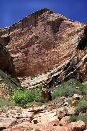
was easy and flat for the remainder. The canyon was fairly narrow in most
places, perhaps not more than 50 feet, but the walls were not always vertical,
so that it often felt quite open. The floor of the canyon was lushly vegetated
with grasses, forbs, cottonwoods and junipers. A group of 4 hikers passed
us on their way down-canyon, and that proved to be the only group of people
we saw in the canyon all day. When, after ½ mile, the trail proved
to show no more wet and mucky spots, we stopped and changed into our boots
that were more suitable for the dry, rocky trail. From that point, we continued
up canyon about another 2 miles, enjoying the rugged desert landscape,
but lamenting that we encountered no waterfalls or narrow slots. The canyon
gradually diminished in depth until it was no more than a ravine. I suspect
we were very close to the Yampa Bench road at that point, but we never
made it that far. Instead, we turned around and made our way out the way
we had come in. At the mouth of the canyon, I encountered some difficulty
getting back down the steep section, and this took a little bit of time.
In the end, I made it down without any broken bones, and happily continued
on the trail. We returned to camp about 5 hours after we had left. In
the dark of the thin canyon, it was much cooler, with a scent of wet earth
that was both refreshing and energizing. We walked up canyon to the first
obstacle: a pool of water that could not be circumvented. Larry went up
first, donning his watersocks. As I had no watersocks, I wore my tennis
shoes and walked into the water and up the steep sandstone rock on the
other side. A short series of steep climbs passed quickly, then the walk
was easy and flat for the remainder. The canyon was fairly narrow in most
places, perhaps not more than 50 feet, but the walls were not always vertical,
so that it often felt quite open. The floor of the canyon was lushly vegetated
with grasses, forbs, cottonwoods and junipers. A group of 4 hikers passed
us on their way down-canyon, and that proved to be the only group of people
we saw in the canyon all day. When, after ½ mile, the trail proved
to show no more wet and mucky spots, we stopped and changed into our boots
that were more suitable for the dry, rocky trail. From that point, we continued
up canyon about another 2 miles, enjoying the rugged desert landscape,
but lamenting that we encountered no waterfalls or narrow slots. The canyon
gradually diminished in depth until it was no more than a ravine. I suspect
we were very close to the Yampa Bench road at that point, but we never
made it that far. Instead, we turned around and made our way out the way
we had come in. At the mouth of the canyon, I encountered some difficulty
getting back down the steep section, and this took a little bit of time.
In the end, I made it down without any broken bones, and happily continued
on the trail. We returned to camp about 5 hours after we had left.
|