Corner Mountain
Trails
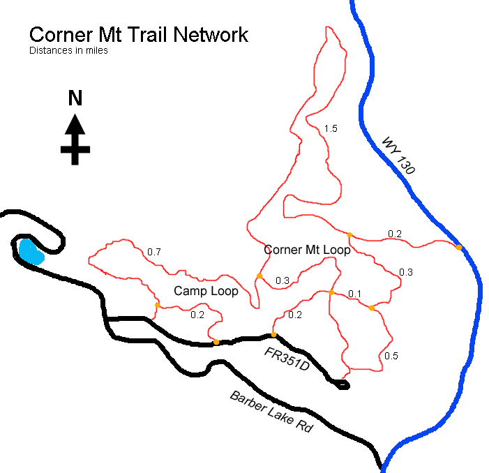
October 16, 2011 Its a nice October morning, strangely warm. What to do with such a day? Spend it on the couch reading a good book? Watching a great movie on DVD? Treadmilling at the gym? Of course not. The only sensible thing to be doing on what has to be one of the final warm days of 2011 is to be out in the forest, stepping out in long strides, crunching fallen aspen leaves definitively on the dry trail under Vibram soled boots, enjoying the flickering sunlight through the naked tree trunks in the woods, fueled by a sun that has sunk far too low on the southern horizon to mistake the season for anything but fall. The crisp air is invigorating. The silence is captivating. Theres no where Id rather be on a Sunday than where I am now, in the Medicine Bow National Forest of southeast Wyoming, checking out a trail network Ive never seen before. Makenzie and Henry are with me. Poor Henry gets so excited he literally quivers as I let him out of the car. I knot an orange bandana around their necks before they race down the trail from the parking area, slobbering and frothing like the mad hounds of hell. I slide a day-glo orange vest over my backpack and sport a cool orange ball cap myself. Were off. The trail is typical of the area, as it runs through a forest dominated by lodgepole pine that are mostly dead, compliments of our friends, the bark beetles. Aspen trees make frequent appearances, although by this time of year, most of the brilliant yellow leaves of September are gone. Henry and Makenzie trot along at the limit of my observation. On a busy trail, such distances would make me nervous, but as my car was the only one in the lot, Im fairly confident I wont see many folks. I do encounter a couple walking not far from the TH, but as they also have dogs on the loose, nobody is worried. It seems odd to be walking at 8300 in mid-October without even a hint of snow on the ground. The sun angle is very low, and the weak light it sends down through a high cirrus cloud layer is white and pale. The air has the unmistakable feel of fall. Maybe its the smell of old aspen leaves on the trail, or something the pines put out, but the air even seems to smell like fall. I think of apple pie, warm cider, egg nog and hot coffee. We tromp on, following the Corner Mt Loop to its intersection with the Camp Loop. With my GPS on, I take every right turn in the trail that I come to, backtracking each time I reach a road or a campground. Most campgrounds are empty. I only see a couple of campers parked in the area, though the forest is thick and can easily give cover to many campers. Most of the woods near the campgrounds is filled with dead pines that have blue slashes painted on them, meaning they will shortly be cut for timber. There are disappointingly few pines that have no marks. Near one of the campground spur trails we come upon a shallow pond and the dogs jump right in. The pond is not quite right. It has no outlet, but sits in a depression in the shaded forest. One would think it had always been there, yet large dead pine trees stand in the water, along with green aspen. Its apparently wet enough to kill all the pines, or did they all die because of bark beetles? And, its not wet enough to kill the aspen, even though they are currently in a foot of water at the end of the dry season. Most things in the forest quickly make sense, and you can read the story from the evidence at hand. For this little pond, I can make out no such simple story. It just doesnt make sense to me. Through taking every right turn and finding out where it goes, I finally arrive back at the trailhead, and a final reckoning of the trail network. Its not as large as I had always imagined. Its pleasant, but not thrilling. Its the kind of trail you stroll on without a purpose, as opposed to trying to summit a mountain.
|
;)
;)
;)
;)
;)
;)
;)
;)
;)
;) |
;)
;)
;)
;)
