| Harney
Peak
Location: Black Hills National Forest, South Dakota August 29, 2004
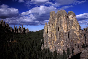
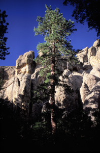
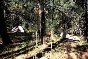
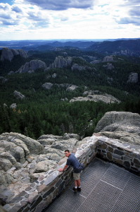
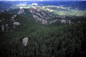
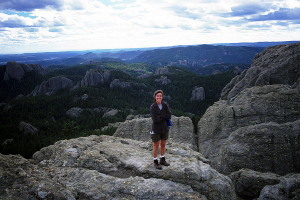
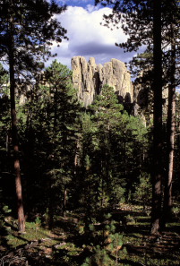
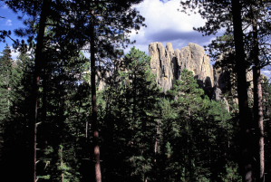
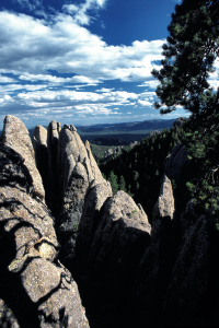
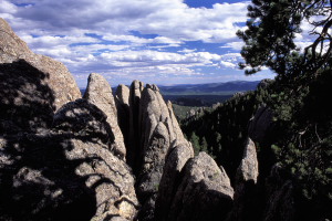
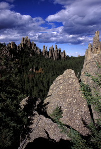
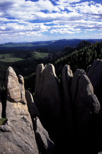
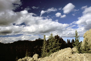
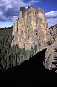
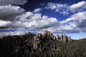
Our first goal was to hike up to the top of Harney Peak, being the highest point in South Dakota, and by virtue of the low elevations found in the eastern US, the advertised highest point between the Rockies and the Pyrenees. How high is it? 7242 feet. However, rumor has it that the makers of the sign at Harney Peak that proclaims such ostentatious fame ignored 7825-ft Emory Peak in south Texas, which is 36 miles further East than Harney Peak, and 681 feet taller. Aha! I have not researched maps to verify either claim, because neither claim is relevant to this story. We parked at Sylvan Lake, which is inside the fee-for-entry Custer State Park, and shouldered light loads for the presumed light hike to Harney Peak. The parking lot was full, but the trail had little traffic. It started out wide and spacious and remained so for over a mile. Dave attempted to contact Matt and Susan again from his mobile phone so Andra and I could tell them our news, but we got no answer. The sun was shining and it was quite warm. The lower elevation afforded more deciduous trees than we usually see in Colorado mountains, and all still green. Nevertheless, the dominant species was Pinus ponderosa, stretching for dozens of miles in every direction in dark green ranks. A high percentage of the pines were browning, I am guessing from bark beetle infestation. The area seemed to be a relatively dry location, so I was surprised to find abundant ferns and moss on the north slopes by the trail. Still, it was dry when we were there, and we never once saw running water at any of the places we hiked. Shortly before we got to Harney Peak proper, we entered the Elk Wilderness, where we encountered mandatory registration. That is the only time Ive ever seen mandatory registration, and something about its compulsory nature urged me to avoid it, though I always register when asked nicely to do so. Nevertheless, we registered our party of 3 for the walk into Elk Wilderness, and were soon past the boundary. The trail narrowed, but never got very steep. We came at the peak from one of the northern trails, and returned on a loop branch that fed further south toward Cathedral Spires. The peak itself came into view rather suddenly, standing out conspicuously by its civilized look. I had not expected a brick building at the summit, but that is what greeted us. Carefully hewn stairs in the steep rock face near the summit led upward to a ledge with a marvelous view of the mountains in virtually all directions. Thick dark clouds had developed in places, and sent plump dark shadows sailing along the forested earth. More stairs led up to the fire lookout tower, and more stairs led to the very top, where I gripped firmly onto the railing as I peered out the large windows to the rocks below and the forest beyond. We spent 30 minutes or so exploring the network of rooms and halls that composed a rather sophisticated building. The difficulty lay in determining what part of the mountain was pre-man and which part was mortared together by CCC workers. Dave tried one final time to contact Matt and Susan and got nothing. That was the final attempt. We headed down. As mentioned, we took an alternate route back to the car, swinging south by Cathedral Spires and Little Devils Tower. I confess at never seeing anything that resembled Devils Tower, but without consulting the map, I knew just which rocks were the Cathedral Spires. I scrambled over a large rock formation to get in position to photograph them, then waited for several minutes for the sun to break through the clouds and bathe them in orange light. Dave and Andra waited by the trail, and were just coming to look for me when I returned. We continued on downhill in the afternoon light, stopping to take photos at nicely-lit spots, and talking about all sorts of things the entire way. On this occasion, we were not stealthy, quiet hikers. Dave is from Hawaii, and visits to the states are rare, so we have to cram in as much storytelling as possible during a 3-day trip. Back at Sylvan Lake, I enjoyed the convenience of an outhouse with running water to wash up. We consulted the map and decided to leave the state park and camp along Palmer Creek, shown on the map to be only 4 miles away. We drove off on a little dirt road and found a trailhead for a path that led up along Palmer Creek. Unfortunately, there was no water in the creek. Kicking myself for not thinking of it earlier, I drove back to the state park and filled all our empty canteens and drove back to the creek parking area. Dave and Andra had meanwhile packed in what gear we needed and begun setting up camp about ½ mile from the dirt road. Apparently they had searched for quite some time for a flat spot, found it, set up camp, and then noticed they were only about 30 feet from a trail that snaked through the area. Since ours was the only car in the lot, we decided not to move camp. Dinner consisted of delicious fried burritos. Dave brought a magazine "101 Things to do in Oahu", which I thumbed through in the waning light in preparation for Novembers trip to Hawaii. Dave had a small one-man tent and Andra and I shared a slightly larger tent nearby. As dark settled, I hung the food and crawled into my sleeping bag. The moon was bright and yellow as it popped up over the horizon, sending shadows from the tree trunks across the tent fabric. A warm, dry night followed. We all woke up more or less simultaneously when the sun arched over the horizon and began cooking the tents around 7:30. We slowly packed up camp and ate oat bars for breakfast. A short walk along the trail led us back to the car, where I was greeted with the site of my John Kerry bumper sticker partially torn from my cars bumper. Vandals! Not to worry, I got two of them in the mail. I had a replacement Kerry-Edwards sticker on the car before the end of the week. We cruised east toward the little town of Keystone. Ive never had any desire to see Mt Rushmore in person, especially when I learned it cost 8 bucks to get in (waste of a beautiful mountain if you ask me). We stopped at a stop light near the front entrance and I looked to my left and got a good, long look of the sculpted mountain before a giant SUV pulled up next to me and blocked the view. Nevertheless, I got a great view of the site and cruised on when the light turned green, having wasted neither time nor money on it. Just past Keystone (both blocks) lies Rushmore Cave. Roadside billboards praise it as "The Closest Cave to Mt Rushmore". Well, hot diggity, if thats so, then I just had to see it. Preparing myself for a tourist trap along the lines of a 20-foot mineshaft with planted glass nuggets, I was pleasantly surprised when we embarked on a 45-minute tour through a ¼-mile cave with large chambers and thrilling tight passageways. Not bad for $7.50 a head. After our tour in the cool cave, we emerged into the bristling heat of August in South Dakota and drove back into Keystone for lunch. I dont recall where we had lunch, but it had the word "Family" in the name (every restaurant seemed to). We all had burgers and sodas at this 50s-themed diner, and enjoyed 7-foot "Big Dave" walking down the middle of the street and cracking a bullwhip to rustle up customers for his wild west show. I snickered at the sight from the doorway of the restaurant as we were leaving, then felt obliged to straighten my face as the 7-foot man with a giant bullwhip glared right at me. Hey, when a really tall guy with a whip wants to walk down the middle of Main Street and yell at people, I guess its best just to let him do what he wants. Back in the vehicle, we scooted
on north through the very narrow town of Deadwood, stopping at the Taco
Johns for a soda. By 4:00 or so, we had crossed the state line and were
closing in on Devils Tower.
 |
|
|
|
|
| Page created 2-16-05
Updated 1-9-12 Comments |