| Stough Creek Basin, Wyoming
Location:
Popo Agie Wildneress, Shoshone National Forest, Wind River Range, Wyoming
Trail: Moderately
strenuous, 8.7 miles, elevation gain 1700'
Maps: USGS
7.5' quads: Cony Mt, Sweetwater
Gap
Fees:
None
Access: From
Lander, take Sinks Canyon Rd west 13 miles to the end of pavement, where
it becomes Louis Lake Road (FR 300). After 2 miles, turn right onto FR
302 towards the Fremont County Youth Camp. Go 4.5 miles to the end of FR302
and park.
Trailhead: NAD83
z12 669401e 4729582n Elevation: 8850'
Dogs:
Leash control
Webcam: 10 miles
south at South
Pass
Weather: Current
Conditions Local
Forecast
July 4, 2002
We had entered the Shoshone National Forest shortly before, laboriously
cruising up a dozen or so switchbacks on a dirt road to get to the trailhead.
I parked the car next to a row of horse trailers and we loaded our packs
with what turned out to be tons more food than wed ever need on a four
day trip. At around 2PM, we were off, Makenzie noisily wheezing through
her self-constricted collar (by virtue of strong leash tugging) and Frank
nosing along the ground set to point and then dart at small game hiding
in the undergrowth of the forest. The day was bright, sunny and clear.
Fair weather cumulus clouds sat on an invisible glass plate in the sky,
like dollops of fat-free whipped topping. I signed in the register and
read the names and origins of other hikers we would meet on the trail.
I noticed quite a few from Colorado, but the majority hailed from nearby.
Andra impatiently waited until I took the clue and we set off up the trail.
Within moments we entered the Popo Agie Wilderness (prounounced Popozsha).
The path here was wide and we loped along the flat trail side by side,
dogs in front. We passed four packers going out and a group of 4 anglers,
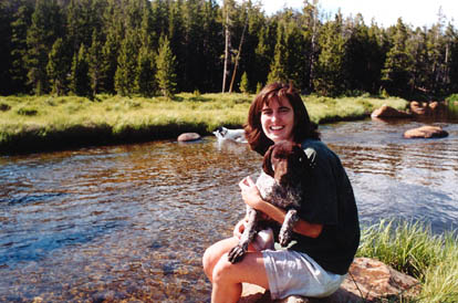
also going out. In no time we reached Roaring Fork Lake, and were so enamored
by the stream that led out of it that we stopped and played for awhile.
The stream was about 20 feet wide, 3-4 feet deep and very slow moving.
It meandered through a thickly-grassed meadow surrounded by thin, dark
pines. We shed our packs and shoes and waded into the cool water. Frank
jumped right in, but Makenzie was hesitant. It took quite a lot of coaxing
to get her to take the plunge. Once she did, we discovered that she was
actually a pretty fair swimmer, for a 3-month old. She 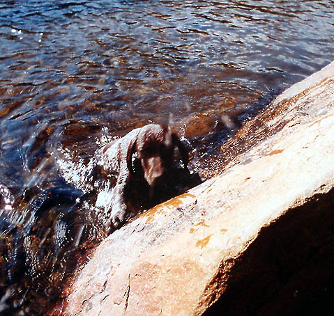 glided
through the water with the ease of a pro, with only her little brown head
above water. When picked up out of the water she would keep her little
legs churning as if she were still swimming, just like Frank did at Lake
Maconaughy several years back. We entertained ourselves by throwing objects
into the stream and watching the dogs charge in after them. Frank was especially
anxious for us to toss in more floating sticks as these appeared to offer
the most sport. A group of anglers approached and then passed, heading
downstream for those elusive trout. Andra lobbied for camping right next
to the stream, but the angler traffic and the fact we had only hiked 1
mile from the car out of a possible 6-7 to our final destination goaded
my sense of anxious urgency to suggest we continue on a little ways. I
find it is always hard for me to stop and wait when there is so much to
see up ahead. I would be more pleased, overall, if I could simply find
the first pleasant spot and occupy it without whim or fancy of moving on.
But this is just not in me. Where I should be relaxed, I get ancy, and
feel that to sit still another second will certainly kill me. Therefore,
we moved on across the stream as the map suggested and promptly got tangled
up in thick woods and heavy mosquitoes. By a stroke of navigation and geography
that I still cant understand, we tried to follow the stream back up on
the far bank with the goal of intercepting the trail that surely had to
be found somewhere. We hiked over what seemed like level terrain for quite
some time, then, fearing I had gone too far, began to hike back towards
the creek which we had lost in the thick woods and tributaries. This was
the strange part because we ended up walking down a very long steep hill
to get to the stream only about a hundred yards from where we crossed.
Very strange. I dont know how we got uphill to begin with. At any rate,
once we found the trail we cruised quickly through the warm summer afternoon. glided
through the water with the ease of a pro, with only her little brown head
above water. When picked up out of the water she would keep her little
legs churning as if she were still swimming, just like Frank did at Lake
Maconaughy several years back. We entertained ourselves by throwing objects
into the stream and watching the dogs charge in after them. Frank was especially
anxious for us to toss in more floating sticks as these appeared to offer
the most sport. A group of anglers approached and then passed, heading
downstream for those elusive trout. Andra lobbied for camping right next
to the stream, but the angler traffic and the fact we had only hiked 1
mile from the car out of a possible 6-7 to our final destination goaded
my sense of anxious urgency to suggest we continue on a little ways. I
find it is always hard for me to stop and wait when there is so much to
see up ahead. I would be more pleased, overall, if I could simply find
the first pleasant spot and occupy it without whim or fancy of moving on.
But this is just not in me. Where I should be relaxed, I get ancy, and
feel that to sit still another second will certainly kill me. Therefore,
we moved on across the stream as the map suggested and promptly got tangled
up in thick woods and heavy mosquitoes. By a stroke of navigation and geography
that I still cant understand, we tried to follow the stream back up on
the far bank with the goal of intercepting the trail that surely had to
be found somewhere. We hiked over what seemed like level terrain for quite
some time, then, fearing I had gone too far, began to hike back towards
the creek which we had lost in the thick woods and tributaries. This was
the strange part because we ended up walking down a very long steep hill
to get to the stream only about a hundred yards from where we crossed.
Very strange. I dont know how we got uphill to begin with. At any rate,
once we found the trail we cruised quickly through the warm summer afternoon.
The trail followed a steep contour course up into a hanging valley and
very soon we crossed a stream in the trail that had been my initial choice
for camp #1. Here I had to search for a good 20 minutes before finding
a flat spot of real estate big enough to squeeze most of our tent onto.
This being done, we shed our packs and sat by the nearby creek and filtered
water and cooled off. Our camp was just under the forest canopy near the
edge of a sweeping meadow of tussock grass and rivulets of clear, cold
water stretching to the base of a nearby mound of granite.
We cooked dinner several dozen yards from our tentsite and took extra care
to hang the food out of reach of bears. A coworker had warned me that his
hiking-partners food had been snagged by a black bear in this very area
last year. It was at dinner then, that we first noted the severity of the
mosquito problem. We both applied gobs of bug repellant (after several
bites, of course) and then felt the need to lather up the dogs after clouds
of the little buggers coated their coats. We also noticed with shock that
some other type of fly had bitten the dogs profusely on their bellies where
the fur is almost non-existent to create bright red blotches. These looked
much more serious than mosquito bites, and we applied extra repellent in
those areas. These bites, in fact, resembled bites Andra and I would also
receive and be scratching at for more than a month. I still do not know
what kind of insect makes those bites. At the time, we assumed that
the mosquito concentration was linked to the proximity of the boggy meadow.
This, ultimately, had little bearing on the situation.
We were
both pretty tired from the long drive and short hike so we went to bed
before dark (not hard when the days are 16 hours long) and slept well.
I was particularly cozy most of the night. Makenzie was sure to wake us
at around 5 by frantically pawing and fumbling around our crowded tent.
Tent and sleeping bag nylon has a way of being extremely loud when a clumsy
dog is sliding about all over in the dead of the morning. Andra and I woke
up grudgingly, and once awakened, got up and started the day. Frank had
to be dragged out of bed, although, once up and about, had great fun stalking
who knows what in the raspberry thickets.
After a leisurely breakfast, we took our time packing up camp. Once we
got started it was quite warm, and we started uphill almost immediately.
The trail was steep and contained about twenty switchbacks up and over
a high pass. The rock slopes we passed and the high craggy peaks were very
cool. We passed water only once, and failed to take advantage of it. The
result was that we were bone dry by the time we reached a stream on the
downside of the pass, and we were very thankful to see it by then. At the
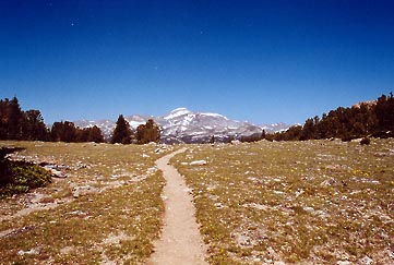
top of the pass we were presented with an amazing view of the Wind River
Range trailing up to the north, sparkling with snow under the mid summer
sky. The moment would have been so much nicer had we not been constantly
swatting at biting flies and mosquitoes. At the pass there was also another
bug present that didnt necessarily bite, but swarmed and caused itching
merely by skin contact. Anyway, we moved on quickly so as to get away from
the pesky swarms and as long as we were moving, we were fine. But everywhere
we stopped to get water or rest, the bugs were on us in an instant. Where
were all the spiders? With arthropod populations like this youd think
the forest could be one giant web. The afternoon brought clouds and as
we reached the final leg of the trail, I fretted about rain. The bugs and
heat had conspired against us and we were both approaching a less than
zen-like state on the matters of the day. The final frustration was when
we hiked almost an hour over what should have been only ½ mile of
trail. This was the second geographical mystery of the trip. Somehow, between
the time this map was printed and the time we hiked the printed route,
the mountain had stretched more than a mile!
We finally made it to the first of the many lakes in Stough Basin and I
spent about 20 minutes once again locating a flat piece of ground with
the criteria of flatness, tent-sized and in this case, not directly near
someone elses camp. I finally located a place and we set up camp
quickly under a brutal torpedoing of mosquitoes and black flies. I had
contracted a 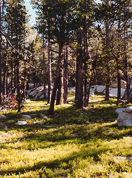 pretty
severe headache by then, and the heat was oppressive. There was no wind,
and although it was cloudy, the sun just seemed then to be coming from
everywhere at once. We brushed the bugs off the dogs and threw them in
the tent, then hopped in ourselves and napped a hot, sweaty hour away.
I woke up as the sun peaked from behind the clouds and shone in my face.
I felt much better and determined that it was time to fish. We exited the
tent into a cloud of mosquitos, and quickly applied more bug repellent,
oiling our skin and feeling quite disgusting. I assembled my fly rod and
we trotted out of the trees and downhill to the lake. I immediately spotted
several trout gliding along just below the surface, so I started whipping
my fly out there, a clever mosquito imitation, and slowly dragging it back
in. The fish completely ignored it. Many, many times I watched fish in
the clear water approach my facsimile and turn their noses up and dart
off. I walked the whole edge of the lake, and tried numerous flies, with
similar results. Andra had brought her book down to the shore and sat trying
to read but quickly gave it up because of the necessity to continuously
swat the dang mosquitoes. I also found it hard to fish, as I had to brush
my face and neck every 2 or 3 seconds. I had applied bug spray to what
I believed to be every patch of exposed skin, however, the mosquitoes quickly
audited the work and showed me where I had missed. Additionally, they bit
my lips! Andra and I walked up to the next lake but they were just as bad
there. The entire area between lakes was a swamp, a giant pete bog of soft,
floating mats and a million tiny streams of water. The mosquitoes were
unreal. We retreated back to the tent and huddled inside while we planned
our next move. It had become clear that meaningful, out-of-tent activity
would not occur. We had little hope of finding fewer bugs elsewhere, but
at least wed be closer to the car when one of us finally required a blood
transfusion. pretty
severe headache by then, and the heat was oppressive. There was no wind,
and although it was cloudy, the sun just seemed then to be coming from
everywhere at once. We brushed the bugs off the dogs and threw them in
the tent, then hopped in ourselves and napped a hot, sweaty hour away.
I woke up as the sun peaked from behind the clouds and shone in my face.
I felt much better and determined that it was time to fish. We exited the
tent into a cloud of mosquitos, and quickly applied more bug repellent,
oiling our skin and feeling quite disgusting. I assembled my fly rod and
we trotted out of the trees and downhill to the lake. I immediately spotted
several trout gliding along just below the surface, so I started whipping
my fly out there, a clever mosquito imitation, and slowly dragging it back
in. The fish completely ignored it. Many, many times I watched fish in
the clear water approach my facsimile and turn their noses up and dart
off. I walked the whole edge of the lake, and tried numerous flies, with
similar results. Andra had brought her book down to the shore and sat trying
to read but quickly gave it up because of the necessity to continuously
swat the dang mosquitoes. I also found it hard to fish, as I had to brush
my face and neck every 2 or 3 seconds. I had applied bug spray to what
I believed to be every patch of exposed skin, however, the mosquitoes quickly
audited the work and showed me where I had missed. Additionally, they bit
my lips! Andra and I walked up to the next lake but they were just as bad
there. The entire area between lakes was a swamp, a giant pete bog of soft,
floating mats and a million tiny streams of water. The mosquitoes were
unreal. We retreated back to the tent and huddled inside while we planned
our next move. It had become clear that meaningful, out-of-tent activity
would not occur. We had little hope of finding fewer bugs elsewhere, but
at least wed be closer to the car when one of us finally required a blood
transfusion.
So we packed
up camp without ever having camped there, and in half an hour, were back
on the trail heading down. The clouds had steadily built back up during
this time and once again, I fretted we would get drenched before we pitched
the tent. We found a place that was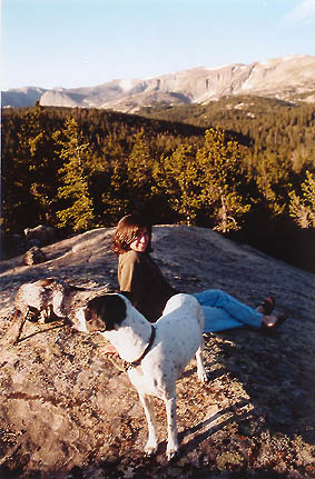 visually
much more interesting than our previous spot and apparently had fewer bugs.
This latter observation turned out to be incorrect, as we believe it only
took time for sufficient brigades of bugs to be alerted to our arrival.
Once they had our coordinates, they zeroed in for the kill. The site itself
was under lodgepole pines, with an understory of bright green forbs, located
near a clearing where the face of an immense granite boulder peaked out
for twenty or thirty feet. Andra stayed near the tent while I once again
tried fishing in the nearby stream that had backed up into a nice pond.
The mosquitoes were worse than ever, but the fact that I actually caught
something made me think less of them. I had great luck overall, catching
11 small trout. I cleaned and cooked several, but the bug swarms made even
this task difficult and miserable, and I cant say I really enjoyed them.
It was about this time that our bug spray ran out. We were only too happy
to get back into the tent and sleep once dusk came. visually
much more interesting than our previous spot and apparently had fewer bugs.
This latter observation turned out to be incorrect, as we believe it only
took time for sufficient brigades of bugs to be alerted to our arrival.
Once they had our coordinates, they zeroed in for the kill. The site itself
was under lodgepole pines, with an understory of bright green forbs, located
near a clearing where the face of an immense granite boulder peaked out
for twenty or thirty feet. Andra stayed near the tent while I once again
tried fishing in the nearby stream that had backed up into a nice pond.
The mosquitoes were worse than ever, but the fact that I actually caught
something made me think less of them. I had great luck overall, catching
11 small trout. I cleaned and cooked several, but the bug swarms made even
this task difficult and miserable, and I cant say I really enjoyed them.
It was about this time that our bug spray ran out. We were only too happy
to get back into the tent and sleep once dusk came.
The next morning
was beautiful and cool and Andra discovered a gorgeous lookout of bare
rock up through the trees from camp. We walked up there and spent awhile
enjoying the view, with only marginal interruption from bugs (less than
100 on you at a time). I went fishing again and caught 5 more trout, and
put them all back safe and sound. I wrestled with the agony of leaving
a place so soon without any exploration, but could not seriously visualize
taking the clouds of mosquitoes another day. Thus, we packed up camp and
headed down, my weeks-in-planning trip ended before it ever really began.
Never before, and I hope never again, will bugs be such an influential
factor in a camping trip. You would have to have been there to believe
it. The amazing thing was that when I had camped nearby at Leg Lake only
two weeks before, I had not encountered a single mosquito. We mustve just
hit the worst part of a breeding cycle or something.
A pleasant sun-filled morning filled us with good cheer along the first
leg of our hike, but even before 11, clouds rolled in, blackened the sky,
and started throwing water down on us. This was more than just a shower,
unfortunately, and soon we were pelted by ice-cold drops as big as marbles
and later, small hail. We donned our raingear, but still got soaked. The
dogs shivered pathetically in the cold. 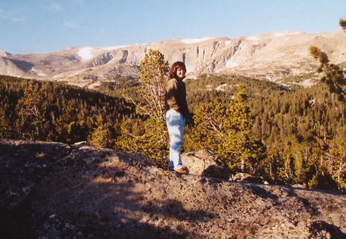 We
had tentatively planned on camping near the creek where the dogs had swam
and we had not noticed bugs, but when we got there we were soaked, the
sky was one shade of pale grey from horizon to horizon and the meadow looked
damp, boggy and cold. So, we walked another mile back to the car and drove
towards home. We
had tentatively planned on camping near the creek where the dogs had swam
and we had not noticed bugs, but when we got there we were soaked, the
sky was one shade of pale grey from horizon to horizon and the meadow looked
damp, boggy and cold. So, we walked another mile back to the car and drove
towards home.
The sun came out and our spirits rose and we had a nice time in the car
while heading south. I studied the map and we decided to try to find a
spot in the Medicine Bow NF outside of Laramie to camp. This we did, next
to a small creek whose name escapes me. It was a pleasant camp with very
few mosquitoes and a cheery atmosphere. Large spruce lined the creek and
an old cabin foundation rested nearby. We had not arrived until late afternoon
so by the time we got dinner made and camp set up it was dark. In the darkness,
Frank ate part of a deer leg he had found. At 5AM, I awoke to Andra trying
to unzip the tent before Frank puked. She didnt make it, and dijon-colored
deer-leg vomit sprayed onto her legs and sleeping bag. Terrible, awful
way to start the morning. She cleaned her legs with the alcohol wipes we
brought for cleaning hands and wiped it off the sleeping bag as best as
can be done in the woods. We cooked breakfast, and then Andra napped under
a spruce tree for a couple of hours while I read my book and packed up
camp. I took another short few moments to fish the creek and caught one
very small rainbow. Then we headed on. We stopped for a half hour at the
Snowy Range area and I hiked up a bit and took a few photos. Again, the
lack of bugs was conspicuous. We rolled into Laramie long past lunchtime
and had a crappy burger at Hardees before driving the last hour home.
I was very much looking forward to the trip
to this area, but I had never, ever counted on mosquitoes and flies as
having the potential to turn beautiful scenery into a hellish existence.
At least it was a trip we could improvise on and ultimately abandon when
it just turned out to be no fun at all. Also, it taught me the importance
of having plenty of bug spray on hand.
Prints
and Digital Imagery from this trip location, and others, are available
for sale in the Wyoming album at

|