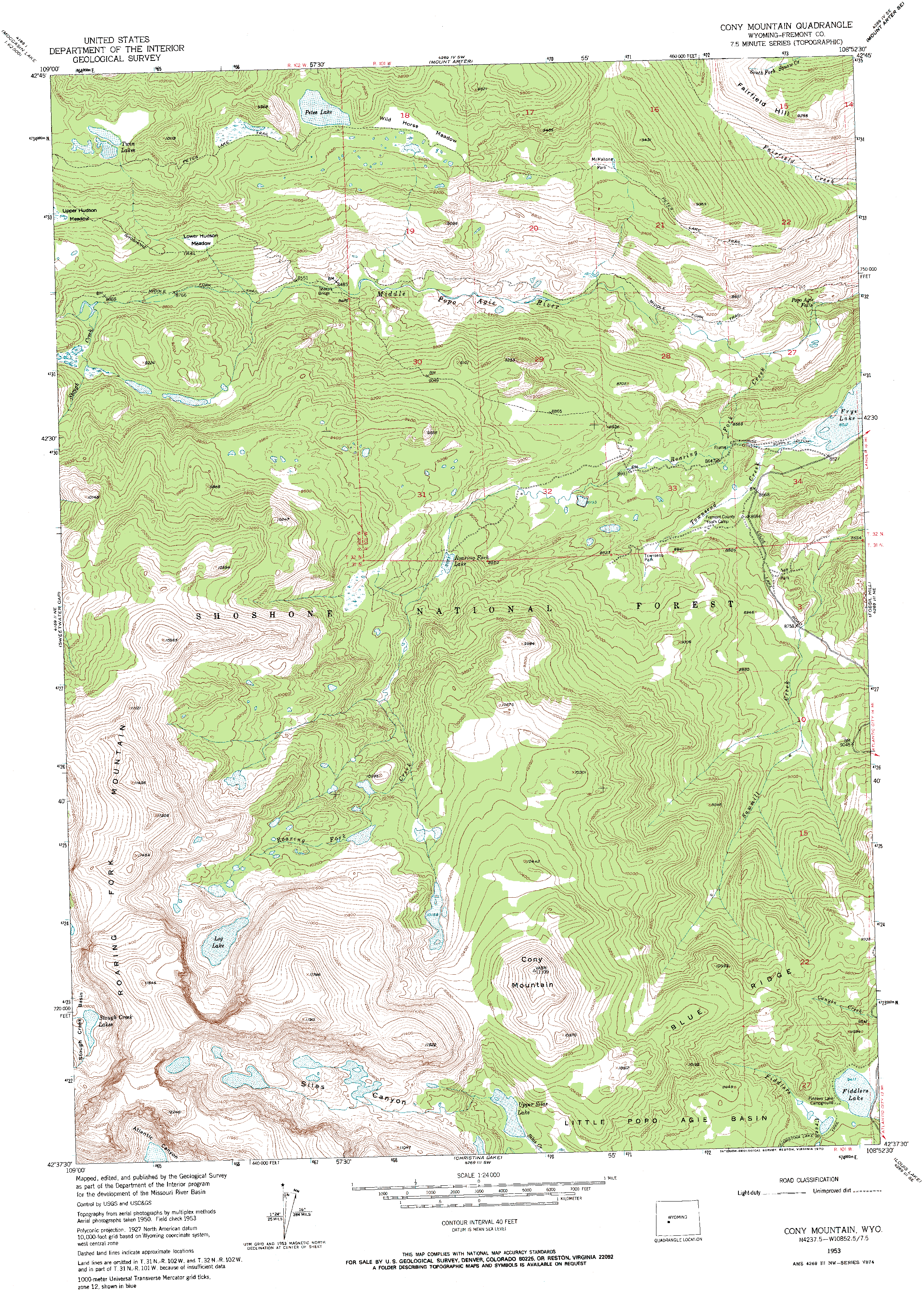
Silas Canyon
August 9 2012 My friend Mike and I took our first outdoor adventure together in 1994, a short raft trip along the cedar-studded shore of Possum Kingdom Lake that ended in a punctured raft compartment and a very slow, long row back to camp. Eighteen years and several trips later, Mike and I were cruising west out of Lander on a sunny afternoon with windows down and the heat rising off the blacktop. Just past the University of Missouri geology camp within the oxide-stained walls of Sinks Canyon, I recognized that I had completely spaced getting gas in town, and we had to turn around and head back in to Lander to fill up. That really put us behind, but its always likely to dampen the return trip excitement if you run out of gas up in the forest. When we finally did reach the trailhead just south of Fiddler Lake, it was already 5:00 in the evening. I hurriedly strapped my tent and sleeping bag on to my trusty Kelty pack, the same one Ive used for 16 years, and Mike busily prepared his own pack. Ready to go. I hoisted my pack up and in a practiced motion reached out for the hip belt that comes swinging around from the momentum of swinging the pack, but the strap wasnt there. I reached for it multiple times, and then put the pack down to examine what it was hung up on. To my horror I saw there was no hip strap. In seconds I recalled a deep winter day months ago when I decided the lack of working pocket zippers had finally put the old green pack up for retirement, and I had removed the padded hip belt and put it on my spare pack, which was now sitting forlornly at home in my gear closet. Gear fail. I took a spare strap and wrapped my sweatshirt around it, then tried to use it as a belt to help support the pack, which worked pretty well for about 10 steps before the plastic buckle on the strap snapped in half. So, with no other option, we hiked on in, and I got used to having no feeling in my arms for the next couple of hours. We passed by the southwest shore of Fiddler Lake, and then into a deep forest of lodgepole and limber pine. Being on the eastern front of the mountains, it grew dim fairly soon. We watched carefully for signs of the turnoff to Silas Canyon. We passed by the Popo Agie Wilderness boundary, and found our spur trail alright. When we finally reached Silas Creek, it was dark enough that only by virtue of the well-trod trail could we even tell where we were going. We hiked up the south side of the creek for a time, then we pulled into the woods about 60 yards and found some flat area amongst tall limber pines to pitch the tents. It wasnt the best campsite we might have found, but it was getting dark, and difficult to see much in the deep woods. The ground was soft and comfortable, at least, so that was good enough. We cooked a quick dinner in the twilight, and by the time we finished it was full dark. With flashlights, I hung the food from a nearby tree and climbed into my tent for a nice rest. August 10, 2012
In camp we cooked dinner, washed up, and sat around in the glow of the sunny evening under the limber pines until dark. August 11, 2012
After an hour of enduring the wind, we hiked back down to the two unnamed lakes below. The southern of the two lakes was eutrophied and brown, but the northern lake was deeper, larger and full of fish. Upon reaching the shore, which was a 4-foot sheer drop into very deep water, Mike looked down and saw a giant cutthroat hanging out just a foot off the rocks. He had packed his rod, but I had left mine threaded up, so he pointed out the fish. I unhooked the fly and simply let it drop on the water, and the trout took it slowly and casually, without hesitation. Took me a long while to get him in because I didnt have my net with me (silly mistake) and I worried he would break the line before I could get him in. Finally got him to the rocks, a nice 16 cutthroat, and unhooked him. He had a long recovery in the shallows, but eventually paddled off into the deep on his own. This was the largest fish I caught on the entire trip. Mike and I had lunch right there on the shore, drank a lot of water and then continued fishing. We both caught a few cutthroats, all pretty-good sized. Then, we dropped down the drainage to Island Lake and split up, with Mike taking the south shore and I taking the north shore, and agreeing wed meet up either at the outlet, or at camp. For the next several hours I made my way slowly along the rocky, convoluted shore, reeling in nice cutthroats occasionally. No brookies in this lake that I ever saw, in stark contrast to Lower Silas Lake, just downstream. By late afternoon I was at the outlet and I fished in one spot for a long while waiting for Mike. Youd think we could keep track of eachother across the lake, but this lake has the wackiest shoreline youve ever seen. Its more like 2 lakes joined by a channel with an oblong island in the north portion. Add lots of boulders, topography and trees to this scene, and it created a situation where I never once saw Mike fishing on the far side of the lake. After an hour, I decided he must have already come and gone, so I hopped on the trail and cruised on downhill back to camp, where Mike was sitting comfortably, leaned up against a log, watching the woods. We made dinner, and I took
a nice bath out of my canvas bucket down by the creek. After dinner I hiked
uphill through a burn to the ridgeline where I could look south into the
heavily-forested Atlantic Creek drainage, and at the barren upper slopes
of Atlantic Peak just beyond. In all directions, nothing but forest met
my eye. I lingered for a long time on the ridge, then hiked back down through
the trees into the still darkness of the deep forest, almost missing my
tent only a few yards from my chosen course. Slept very well.
August 12, 2012
We packed up our gear and headed out around 11. As usual, the hike out seemed much longer than the hike in, and the lack of a hip belt on my pack made it seem even longer. We reached the car around 12:30, then drove into Lander for a burger at Gannet Grill before continuing the long drive back to Cheyenne.
|
;)
;)
;)
;)
;)
;)
;)
;)
;)
;)
;)
;)
;)
;)
;)
;)
;)
;)
;)
;)
;)
;)
;) |
;)
;)
;)
;)
;)
;)
;)
;)
