
|
Location: Sawtooth Wilderness, Sawtooth National Forest, Central Idaho Maps: USGS 7.5 minute topographic quad: Stanely Lake Access: From Stanely, ID, take Hwy 21 west about 2 miles, then south on the Iron Creek Campground road (theres a sign for Sawtooth Lake) about 3 miles to the Iron Creek TH. A free self-serve wilderness permit is required. Trail: Difficulty is moderate: 5 miles, 1700 ft elevation gain (8430 ft)
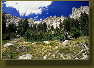
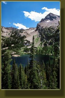
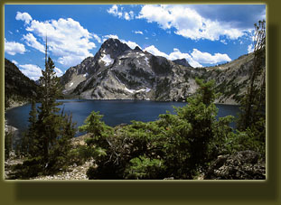
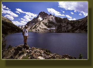
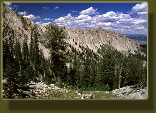
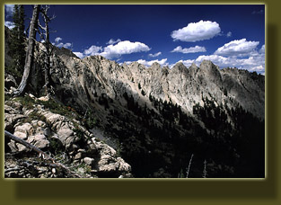
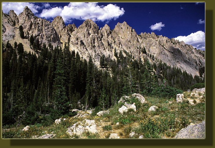
So there I was on Sunday morning, loafing along the Salmon River, enjoying the sunshine and warm breeze of a beautifully clear July day. On days such as these when your responsibilities are zilch, what else should you do? By 10:30 or so I was in the little town of Stanley, feeling hungry. I cruised past the row of shops advertising their fare: pizza, no too early burgers, no too greasy breakfast served anytime .hey that sounds good. I pulled into the quiet diner/river rafting headquarters (smart combination) and walked inside to place my order. I then went to the mens room and washed my hands and face for the first time in 2 days. My order was up when I returned and I held the plate of steaming hash browns, scrambled eggs and bacon very carefully as I walked out the front door and sat down at a vacant table in the cool shade of an awning. I ambled over to grab my Idaho gazetteer out of the car, unrolling the windows to keep it from cooking inside the car, and sat back down to peruse the map and decide where best to spend such a wonderful day. I began to dine on the delicious hot food. As the first waves of salty satisfaction coursed through my blood, I turned my attention to the Sawtooth Range spread out in front of me, both on the map and to my right. I also noted the thin dot-dash boundary of the Sawtooth Wilderness and my days plans suddenly became very clear. I would hike in the Sawtooth wilderness. No jeeps speeding past my quiet repose and muddying the fishing waters downstream like last night on Challis Creek. No bicycles to dodge. No ATVs running you down like at Stoddard Creek. No clear cuts. I was quite pleased at this fortuitous development. But where to start? A gazetteer is a great thing, but it doesnt typically give you much detail on hiking routes. Of course theres nothing in the world wrong with scrambling through the woods willy-nilly, but unless you know the area (which I dont) a simple circuit of 4 miles might eat your whole day, and you may never see anything but tree trunks in all directions. No, I determined I wanted a route that would get me somewhere. I wanted an official turn-around point. I needed a firm destination after the aimless wandering that had taken up the better part of the previous 24 hours after my descent from the shoulder of Borah Peak. I examined the alpine lakes since these unfailingly make great destination trips. Theyre pretty, they motivate you to continue on when you get tired on the trail, and you can only rarely miss them. No trails were marked, but I figured I could be good money that in the Sawtooth Wilderness, there would be a pretty good trail up to Sawtooth Lake. I examined the roads and they seemed to look promising. One never knows how far one can chug uphill on forest roads when one is driving a Saturn sedan. I determined to take my chances. I shoveled down the last bits of salty hashbrowns, savoring the flavor, then deposited my paper plate in the refuse can before driving west. The road to the trailhead was an easy drive. Many cars sat empty in the dirt parking lot, and a few people were busy preparing for their hike. I stepped up to the info kiosk and confirmed that a trail led right up to Sawtooth Lake and tried to memorize the trail route. Then I picked up a mandatory free wilderness registration permit and filled it out, dropping it off after I had grabbed my backpack and camera from the car. The trail was relatively flat for the first 2 miles or so as it led straight west through open pine and Douglas fir stands. I stopped at a marshy meadow to the south of the trail briefly, and encountered my first humans of the hike. They were seated near the water with water bottles in hand. I continued on the trail at a good clip. The trail veered to the south and started gaining elevation rapidly. The sun was warm as it shone on my through the sparse pine tree cover along this section, and I huffed and puffed as I wound up several switchbacks. Through the trees to the west, I could see the bright glaring rocks of the jagged ridgeline that looks very much like a saw. Aptly named. The trail led over Iron Creek that drains Sawtooth Lake, then mounted switchbacks beyond count 5, 6? All were gently graded so that the effort was not much to get past them. The old trail route much more rigorous in its steepness could be seen crossing the current route at intervals. Thick, puffy clouds wafted on unseen air currents overhead, giving depth to the otherwise depthless blue of the sky. I passed by a turnoff to Alpine Lake, and entered another round of switchbacks, steeper than before. As I gained elevation, I enjoyed the great birds-eye view of Alpine Lake and the eastern wall of the Sawtooth range. I topped out on a crest in the trail and descended a little to walk along the edge of a log-bound pond. Beyond that lay the sparkling azure waters of Sawtooth Lake. This is one of the biggest alpine lakes Ive ever seen, and subsequent research revealed it is the largest lake in the Sawtooth Wilderness. I left the trail at the east end of the lake and hiked up a hill that overlooked the lake. Once there, I finally allowed myself a rest after 2 hours of hard hiking. The cloud cover had increased, but was not dominating. I pulled on my long sleeve shirt to shield against the steady breeze coming in off the water. I waited for clouds shadows as I took several photographs of the lake and Mt Regan beyond. Along the south side of the lake, the trail continued to a valley beyond that looked most inviting. If I ever come back, Ill go see what thats all about. As for this hike, I had reached my turn-around point. I walked down to the edge of the lake and sat down. A sharp pain in my foot compelled me to remove boot and sock only to discover that a wood splinter had somehow gotten lodged into the skin in the ball of my foot. Luckily I had a needle in my first aid kit and quickly fished it out. After relaxing at the waters edge for 20 minutes or so, I retraced my steps back towards the switchbacks, down to Alpine Lake, down to the creek crossing, through the sparse woods into thicker cover and into the flat stretch towards the car. I passed a limping older gentleman who heard me coming and stepped aside. He told me with a smile that when I caught up with a woman and a young girl, tell them he was still alive. I did so as I passed them 15 minutes down the trail. I returned to the car at around 3:15, having completed the trek in about 4 hours. I piled my gear in the car and drove off to Stanely, where I refueled and drove south through the Bear Valley. This seems to me to be one of the most beautiful spots in Idaho, though admittedly Ive not seen many. The emphasis on preservation of the entire valley is notable and seems to be appreciated by the dozens of cars that stopped (as did I) at the Bear Valley overlook on the south side of the valley, before heading into the next drainage.
|
  |
  Browse more nature photographs at www.LandscapeImagery.com Page Created 2-12-06 Comments |