 Unseasonably
warm march weather made March 15, 2003 a perfect, and I mean perfect, spring
day. Temperatures began in the mid 50s and warmed up with the rising sun
to the mid 60s in the lower mountains where I spent my day with two fantastic
canine hiking companions. I had planned out this trip prior to leaving
home using DeLormes Topo USA software that I receieved as a birthday present
from Andras parents, Karen and Bob. I looked at the map of the Poudre
and put dots at the spots I had hiked, and saw that a huge gap existed
between Sheep Mt and Profile Rock. I decided that since I have only a few
months left of front-range living (sniff) I had better make sure that I
could say I explored the Poudre Canyon thoroughly. Who might I say this
to? Myself, of course. When I am 90 and too feeble to walk to the bathroom,
I will remember that I hiked the heck out of the land surrounding the Poudre
River and be glad. Anyway, I picked a spot that looked promising by virtue
of a nearby towering peak overlooking the highway from the north. I plotted
a basic course that would take me uphill north of the river and follow
a series of draws toward a saddle between two larger peaks. At that point
I would take the ridge to the east and follow it until I could go no higher.
On the way back, there appeared to be another interesting tall peak to
aspire towards. I printed off a small map and was ready to go. Unseasonably
warm march weather made March 15, 2003 a perfect, and I mean perfect, spring
day. Temperatures began in the mid 50s and warmed up with the rising sun
to the mid 60s in the lower mountains where I spent my day with two fantastic
canine hiking companions. I had planned out this trip prior to leaving
home using DeLormes Topo USA software that I receieved as a birthday present
from Andras parents, Karen and Bob. I looked at the map of the Poudre
and put dots at the spots I had hiked, and saw that a huge gap existed
between Sheep Mt and Profile Rock. I decided that since I have only a few
months left of front-range living (sniff) I had better make sure that I
could say I explored the Poudre Canyon thoroughly. Who might I say this
to? Myself, of course. When I am 90 and too feeble to walk to the bathroom,
I will remember that I hiked the heck out of the land surrounding the Poudre
River and be glad. Anyway, I picked a spot that looked promising by virtue
of a nearby towering peak overlooking the highway from the north. I plotted
a basic course that would take me uphill north of the river and follow
a series of draws toward a saddle between two larger peaks. At that point
I would take the ridge to the east and follow it until I could go no higher.
On the way back, there appeared to be another interesting tall peak to
aspire towards. I printed off a small map and was ready to go.
Saturday morning I got up at 6:30 after trying unsuccessfully to ignore
the incessant whining of Andras 10 month old puppy, Makenzie. "Cmon,
Sam, get up, lets goooo!" she seemed to chant. I noticed that the eastern
horizon was clouded over, but the western sky was clear and blue, just
waiting for the clouds to be on their way. After I got dressed and had
a light breakfast, I packed up the canyon maps, food, a book, extra clothing,
a dog water dish and water for myself. We left the house at around 8. The
drive up the canyon was gorgeous with the clear blue sky and warm, dry
air. The ice on the river had started to melt away and flows were picking
up. Traffic was light, and I 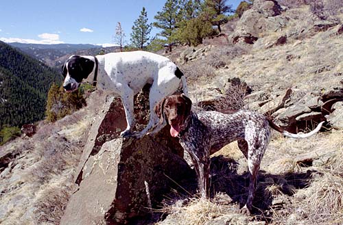 was
able to cruise along at any speed I wished with the windows cracked and
dogs busily sniffing the air rushing in. was
able to cruise along at any speed I wished with the windows cracked and
dogs busily sniffing the air rushing in.
After an hour, I turned on my GPS and zeroed in on the spot I had picked
to pull off the highway. I reached that spot, then drove on about a tenth
of a mile to the next pullout, which happened to be the Kelly Flats off
road vehicle trail parking lot. DeLormes Topo USA shows only select trails,
and did not show this one. In effect, I had replanned an existing trail.
But not entirely, as I soon found out. Mine was the only car in the lot,
so I grew hopeful that despite it being a motorized vehicle track, I could
find peace and quiet. I started off following the rutted dirt tracks at
around 9:15, but before even 100 yards, I diverted to the east and bushwhacked
through the pines and then through the sagebrush on the shallower slopes
beyond the initial ridge. The day was very warm, and I quickly stripped
off my overshirt. The dogs panted like fiends as they prowled the sagebrush
flats. The terrain was very rugged, with lots of drainages crossing the
area that forced me to climb up and down repeatedly. I passed by the edge
of a forest plot, then downhill and under a low-lying power line. That
was the limit of signs of civilization.
I failed to follow my original plotted course very closely, but instead
veered to the east of it quite a lot. Instead of reaching the saddle I
had planned for, I simply went up the south side of the mountain. It was
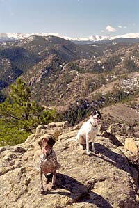
steeper, but more fun. I got to the top of that one, then saw another taller
one to the east so I dropped down and climbed that one. From there I could
see the Mummy Range to the south, something I had not expected, and I was
very excited about the whole thing. I dropped down again and reached the
tallest peak in the area, and the view was 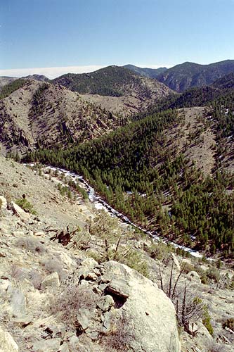 unexpectedly
rewarding. To the east and south I could pick out several places I had
hiked before: Grey Rock, the peak above Youngs Gulch, Sheep Mt, Buck Ridge,
Mt McConnell (just across the highway), Quigley Mt, Mummy Range and somewhere
the peak I had climbed to get morning shots of the Mummy Range last spring.
The Pingree Park Rd snaked along the hillside across the highway to the
west and I could look down upon the Kelly Flats camping area. To the northeast
were the houses I had seen before on my trip up Sheep Mt, looking no more
at peace with the mountain terrain than before. The wind at the top of
the highest point I reached (7618 799 above the parking lot) was practically
non-existent, so I laid out both Poudre River maps side by side (since
I was currently just on the edge between them) and located all sorts of
points of interest. It was a very entertaining exercise. If you every venture
up to this unnamed peak, be sure to take a map or two. What I became most
aware of while I picked out all these places from the map was how close
everything really is up the canyon. When one drives along the road, one
has to follow a very windy and indirect route that often practically doubles
back on itself without the driver really comprehending the big picture.
This takes a very long time, and gives the impression of great distances
being covered. From my perch on the high point of the hike, Grey Rock was
only 8.8 miles to the east, but was 17 miles by road! Thus it was that
all the mountains that stuck out in my memory were like stepping stones,
one right after the other, following the unseen river as it flowed in a
sinuous curving route 1000 feet below me. unexpectedly
rewarding. To the east and south I could pick out several places I had
hiked before: Grey Rock, the peak above Youngs Gulch, Sheep Mt, Buck Ridge,
Mt McConnell (just across the highway), Quigley Mt, Mummy Range and somewhere
the peak I had climbed to get morning shots of the Mummy Range last spring.
The Pingree Park Rd snaked along the hillside across the highway to the
west and I could look down upon the Kelly Flats camping area. To the northeast
were the houses I had seen before on my trip up Sheep Mt, looking no more
at peace with the mountain terrain than before. The wind at the top of
the highest point I reached (7618 799 above the parking lot) was practically
non-existent, so I laid out both Poudre River maps side by side (since
I was currently just on the edge between them) and located all sorts of
points of interest. It was a very entertaining exercise. If you every venture
up to this unnamed peak, be sure to take a map or two. What I became most
aware of while I picked out all these places from the map was how close
everything really is up the canyon. When one drives along the road, one
has to follow a very windy and indirect route that often practically doubles
back on itself without the driver really comprehending the big picture.
This takes a very long time, and gives the impression of great distances
being covered. From my perch on the high point of the hike, Grey Rock was
only 8.8 miles to the east, but was 17 miles by road! Thus it was that
all the mountains that stuck out in my memory were like stepping stones,
one right after the other, following the unseen river as it flowed in a
sinuous curving route 1000 feet below me.
The dogs grew restless before long, and I decided to start down. We
walked down the south slope to a point directly overlooking the road below.
The perspective was crazy from that height, and trees seemed to point every
which way but up, depending on where I looked. The shallow current of the
river shimmered in the sun far below. We sidehilled around to the west
and stopped to rest in the shade of a small, tenacious ponderosa growing
in solitude on a desolate south-facing slope. I took a few moments to pull
cactus needles out of Makenzies paws. We sort of wandered this way and
that, and slowly made our way back towards the car, following no real route,
and certainly no trail. The day grew quite warm, and I found myself wanting
to stop and rest in whatever shade we came upon. There was one particular
gully that was lined by large junipers and offered great shade. I sat down
and 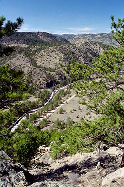 had
a snack, sharing it with the dogs (one would think I never fed them at
home by the way their beady little eyes stared at me when I pulled out
food) and rested. The dogs ate snow from the big patch in the shade, and
Makenzie laid right down in the snow to cool her belly, then started scampering
around looking for trouble to get into. Frank bird-dogged the area with
his tail frantically wagging, and before long his tail was bleeding and
painting red streaks on his side with every wag. Makenzie found a nice
angular rock that I threw into the underbrush for her to find. This is
a fun game to play with Makenzie and one that seldom disappoints. I can
throw a rock in any direction as far as I my arm allows without her even
seeing where it goes and she will find that exact rock and bring it back
to me. Sure, it may take 20-30 minutes for particularly difficult locations,
but her sense of smell is just incredible in this regard. She runs frantically
over the ground, nose to the ground, and before long picks up that scent.
I can see why they would be effective hunting dogs. had
a snack, sharing it with the dogs (one would think I never fed them at
home by the way their beady little eyes stared at me when I pulled out
food) and rested. The dogs ate snow from the big patch in the shade, and
Makenzie laid right down in the snow to cool her belly, then started scampering
around looking for trouble to get into. Frank bird-dogged the area with
his tail frantically wagging, and before long his tail was bleeding and
painting red streaks on his side with every wag. Makenzie found a nice
angular rock that I threw into the underbrush for her to find. This is
a fun game to play with Makenzie and one that seldom disappoints. I can
throw a rock in any direction as far as I my arm allows without her even
seeing where it goes and she will find that exact rock and bring it back
to me. Sure, it may take 20-30 minutes for particularly difficult locations,
but her sense of smell is just incredible in this regard. She runs frantically
over the ground, nose to the ground, and before long picks up that scent.
I can see why they would be effective hunting dogs.
More hiking in the sun, more panting, more beautiful spring day scenery
to soak in. We reached the forest plot, and rested again on the shaded
side of large rock. I leaned up against the cool mineral block, and Frank
curled up against my leg. Makenzie even laid down without prompting (usually
this requires threats), and I managed to drift off to sleep for a few moments.
Very relaxing. When we started hiking again, I decided that I felt quite
good enough to attempt to tackle another large peak nearby. This one was
quite a bit steeper, climbing about 330 feet in just under 0.2 miles. We
climbed the least steep, north face. The trees on the north face offered
a welcome coolness, and security on the steep loose rock incline. If not
for the trees to break a slide down the slope, I would not have been up
there. As it was, I felt quite secure. I could not make it all the way
to the tip-top because of some sketchy scrambles that are required. Deciding
not to chance it, I turned back about 20 feet from the summit. I was disappointed
to get so close and not be able to take that rewarding view to the south,
but I still had nice views to the east, west and north. From where I stood
looking north, I could see the highway coming at me from both the northeast
and northwest, and it gave a great perspective to the winding nature of
the road.

Panorama of Lower Poudre Canyon...............Click for larger image
Getting down took longer, as I wanted to be sure I went down roughly
the same route I had come up, to avoid having to retrace steps that led
to a dead-end drop off. This I did, and soon we were back in the sun again
strolling quickly downhill towards the parking lot. We reached the car
at around 2:30 and sat in the shade to cool off before loading up and driving
home. I figured the hike was around 5 miles, but with all the ups and downs
over rough, un-trailed terrain, it felt like much longer. |