|
Kaena Point
Location: Nortwest
Oahu, westernmost tip
Map: USGS 1:24K
Kaena
Access: Take
the Farrington Hwy northand west literally until it ends. Then get out
and walk.
Trail: Follow
the old road, which turns into nothing more than a footpath over loose
sand. Flat, 3 miles to Ka'ena Point.
Fees: None
Dogs: No posted
restrictions |
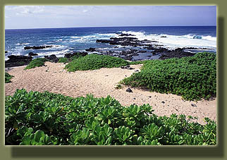
 After
spending a fantastic morning watching man-killing waves at Sharks Cove,
body-surfing at Waimea Bay, then downing a delicious hamburger in Haleiwa,
what could possibly be a more fitting cap on the day than a nice hike to
Kaena Point, the westernmost tip of Oahu and legendary jumping-off point
into the afterlife? We did not intend to do any actual jumping into the
afterlife on this day, but thought it might be nice to have a preview.
We drove the Farrington Hwy until it ended into deeply-rutted two-track.
Then the three of us, Andra, Dave and I, exchanged our flip flops for hiking
boots and set off down the road towards the west, our shirts still wet
around the shortline from swimming. To our right lay the Pacific Ocean,
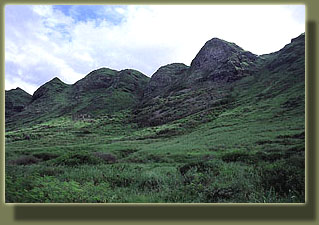
unbroken all the way to the Aleutians, and to our left rose the sharp,
steep foothills of the Waianae Range, carpeted in a verdant rug of greenery.
Clouds overhead threatened rain in the early part of the hike, but began
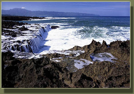
to clear fairly quickly. The coast was rocky and treacherous, by
far too dangerous for any type of swimming, especially on a day such as
this when the sea seemed to be especially irritated at something. Along
the rocky shelves by the water, at odd intervals, pickup trucks were stationed
with three to ten fishing poles braced in the ground on both sides parallel
to the After
spending a fantastic morning watching man-killing waves at Sharks Cove,
body-surfing at Waimea Bay, then downing a delicious hamburger in Haleiwa,
what could possibly be a more fitting cap on the day than a nice hike to
Kaena Point, the westernmost tip of Oahu and legendary jumping-off point
into the afterlife? We did not intend to do any actual jumping into the
afterlife on this day, but thought it might be nice to have a preview.
We drove the Farrington Hwy until it ended into deeply-rutted two-track.
Then the three of us, Andra, Dave and I, exchanged our flip flops for hiking
boots and set off down the road towards the west, our shirts still wet
around the shortline from swimming. To our right lay the Pacific Ocean,
unbroken all the way to the Aleutians, and to our left rose the sharp,
steep foothills of the Waianae Range, carpeted in a verdant rug of greenery.
Clouds overhead threatened rain in the early part of the hike, but began
to clear fairly quickly. The coast was rocky and treacherous, by
far too dangerous for any type of swimming, especially on a day such as
this when the sea seemed to be especially irritated at something. Along
the rocky shelves by the water, at odd intervals, pickup trucks were stationed
with three to ten fishing poles braced in the ground on both sides parallel
to the 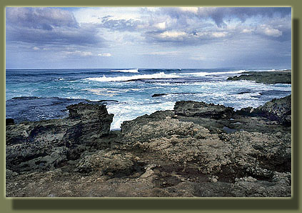 coast,
all with taught lines leading into the choppy water. Occasionally, a few
men could be seen hunched under a crude tarp shelter, but more often, the
coast seemed deserted. The road was straight, going over several small
hills, but pretty easy to walk on, overall. Several times we were forced
to take short detours to get around huge puddles of red muck. This is no
small feat when the vegetation on the roadside stands 4-feet tall and is
mostly impenetrable. After a mile or two, the road truly ended at a closed
gate with mammoth hinges that were long rusted shut. Or, who knows, perhaps
in this wet part of the world they had been installed only last winter.
Signs listed certain forbidden activities, but allowed hiking on foot,
so we continued through a small gap in the gate. The large lane of the
dirt road gave way immediately to a simple foot trail, elevated so as to
afford a more enjoyable view of the water beyond, which beforehand was
largely hidden by the tall grasses. In the steep cliff to the south Dave
pointed out an old WWII lookout bunker of concrete, embedded in the mountainside
and seemingly inaccessible. What a terrible job that would have been, spending
a tour of duty in a quiet, safe, shaded concrete bunker overlooking waves
of green vegetation and ocean skyline. If I ever have the misfortune of
being called to war, I volunteer for that job. Ill do my part. The sun
came out in full shortly after this point, and the temperature seemed to
soar by ten or twenty degrees. Instinctively, I looked around for shade,
but suddenly, as we approached the thin sandy soils on the edge of the
island, beyond the shelter of the mountain range to the south, all vegetation
seemed limited to a height of 2 feet or less. A tower in the distance seemed
to signal the very edge of dry land, and we made for it in haste under
the brutal sun. Much too much work, I thought. Did I want to turn back?
No, just to complain a little. It was still beautiful. Soon, the mountains
that had cut off any view to the south receded into the ground, and ocean
opened up on 3 sides. The trail entered an Albatross breeding area,
and the path was cordoned off with steel posts and wire. Upon reaching
the tower we had been aiming for, we took shelter in the shade of what
appeared to be a toppled concrete tower. Looking back east, we could see
both the north and south shores of Oahu simultaneously, as well as some
sort of weather or radio station on the peaks nearby. It seemed to still
be raining off on the eastern shore, so tantalizingly-close, but the sun
on our end of the island was in no way obscured, a fact I coast,
all with taught lines leading into the choppy water. Occasionally, a few
men could be seen hunched under a crude tarp shelter, but more often, the
coast seemed deserted. The road was straight, going over several small
hills, but pretty easy to walk on, overall. Several times we were forced
to take short detours to get around huge puddles of red muck. This is no
small feat when the vegetation on the roadside stands 4-feet tall and is
mostly impenetrable. After a mile or two, the road truly ended at a closed
gate with mammoth hinges that were long rusted shut. Or, who knows, perhaps
in this wet part of the world they had been installed only last winter.
Signs listed certain forbidden activities, but allowed hiking on foot,
so we continued through a small gap in the gate. The large lane of the
dirt road gave way immediately to a simple foot trail, elevated so as to
afford a more enjoyable view of the water beyond, which beforehand was
largely hidden by the tall grasses. In the steep cliff to the south Dave
pointed out an old WWII lookout bunker of concrete, embedded in the mountainside
and seemingly inaccessible. What a terrible job that would have been, spending
a tour of duty in a quiet, safe, shaded concrete bunker overlooking waves
of green vegetation and ocean skyline. If I ever have the misfortune of
being called to war, I volunteer for that job. Ill do my part. The sun
came out in full shortly after this point, and the temperature seemed to
soar by ten or twenty degrees. Instinctively, I looked around for shade,
but suddenly, as we approached the thin sandy soils on the edge of the
island, beyond the shelter of the mountain range to the south, all vegetation
seemed limited to a height of 2 feet or less. A tower in the distance seemed
to signal the very edge of dry land, and we made for it in haste under
the brutal sun. Much too much work, I thought. Did I want to turn back?
No, just to complain a little. It was still beautiful. Soon, the mountains
that had cut off any view to the south receded into the ground, and ocean
opened up on 3 sides. The trail entered an Albatross breeding area,
and the path was cordoned off with steel posts and wire. Upon reaching
the tower we had been aiming for, we took shelter in the shade of what
appeared to be a toppled concrete tower. Looking back east, we could see
both the north and south shores of Oahu simultaneously, as well as some
sort of weather or radio station on the peaks nearby. It seemed to still
be raining off on the eastern shore, so tantalizingly-close, but the sun
on our end of the island was in no way obscured, a fact I 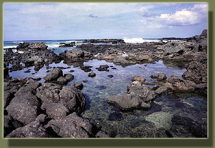 considered
as I drank down the last of my warm water. From that point, it was down
to the rocky coast and the tidepools therein, to observe the myriad wonders
of a tropical sea. Needlefish by the thousands filled one small channel
with their long, tube-like bodies. Crabs and small dark fish darted away
into hidden crevices each time I approached a new puddle. Spiny black and
purple sea urchins were very common. We spotted a few anemones, but not
nearly so many as I would have expected to see. The three of us rock-hopped
all around the sharp, volcanic crust that formed the tidepools checking
out all the interesting fish and critters. At one point we observed a group
of fish taking turns jumping from one tidepool, over a rock barrier, and
into another tidepool, seemingly without any a-priori knowledge that there
even was a tidepool in the direction they were jumping. Amazing clairvoyance.
Soon, we were back on the trail for what seemed like a forced death march
through the stifling heat back to the car. With sunscreen long since removed
by sheets of sweat, my skin reddened steadily under the great iron furnace
in the sky. The hike back seemed, for obvious reasons, to take twice as
long as the hike out. Luckily as we neared the car, the clouds rolled back
in, providing some relief. considered
as I drank down the last of my warm water. From that point, it was down
to the rocky coast and the tidepools therein, to observe the myriad wonders
of a tropical sea. Needlefish by the thousands filled one small channel
with their long, tube-like bodies. Crabs and small dark fish darted away
into hidden crevices each time I approached a new puddle. Spiny black and
purple sea urchins were very common. We spotted a few anemones, but not
nearly so many as I would have expected to see. The three of us rock-hopped
all around the sharp, volcanic crust that formed the tidepools checking
out all the interesting fish and critters. At one point we observed a group
of fish taking turns jumping from one tidepool, over a rock barrier, and
into another tidepool, seemingly without any a-priori knowledge that there
even was a tidepool in the direction they were jumping. Amazing clairvoyance.
Soon, we were back on the trail for what seemed like a forced death march
through the stifling heat back to the car. With sunscreen long since removed
by sheets of sweat, my skin reddened steadily under the great iron furnace
in the sky. The hike back seemed, for obvious reasons, to take twice as
long as the hike out. Luckily as we neared the car, the clouds rolled back
in, providing some relief.
|