| Everybody
who's lived in or visited Ft. Collins has seen Horsetooth Rock (except
my Uncle Dale who, even with glasses on, can't see further than the chrome
Dodge hood ornament on his '86 Aries). I was first introduced to
this massive pegmatite monolith by Dr. Schaff, then director of bands at
CSU, on my first day in Colorado back in June 1995. It is a very
prominent landmark visible from anywhere in the Ft. Collins area, including
the second floor of the Music building on campus (at least it was before
they renovated the north end of the student center). Although its
resemblance to a horse's tooth is dubious, everyone knows it by that name,
and there are at least a dozen businesses who make it an integral part
of their name too. My friend Chuck and I often enjoyed re-creating
what we imagined the original naming conversation must have been like,
spoken in drawling western accent by ranchhands around an evening fire,
trying to come to a consensus on what animal's teeth this rock formation
most resembled.
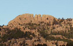
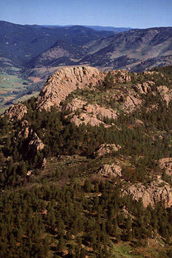
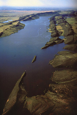
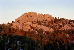
Horsetooth Rock,
or for the slightly more daring, Horsetooth Mountain, towers
7,300 ft only a couple of miles from the edge of Fort Collins (elv 4900'),
just beyond the reservoir which bears the same name. Up until 1982,
it was private property owned by the Soderburg family, but became one of
the the first "open space" tax acquisitions of Larimer county.
The trail winds through
an area, owing to the dryness of the slopes, that is thinly-forested in
most places (with occasional thick stands of Ponderosa pine), and its close
proximity to town often leads to a large herd of overly-vocal folks.
However, it is still a place of high beauty, and if you hit it at the right
time, a place of magnificent quiet solitude, and a haven from the traffic
rolling along double-lane pavement only 3 miles to the east. As far as
city parks go, I doubt it has many parallels in the country. After all,
how many city parks have a natural forest in them? Its rocky, rugged
slopes provide a nursery for cactus, rabbitbrush and shortgrass, with stands
of Ponderosa pines on the northern slopes.
I hiked to the near-top
of the rock for the first time in October 1999 with Andra. I am certain
that my awesome display of rugged hiking prowess is the reason we ultimately
got married exactly 5 years later. And if you're wondering, yes, you can
hike all the way to the top, although a bit of scrambling (and rugged hiking
prowess) is required. Despite the waning seasonal warmth, the day we chose
to hike was very warm, and the open south-facing slopes that dominate the
first half of the hike afforded no respite from the sun's unfettered glare.
I was melting in the heat, and the heavy clothes I had worn in anticipation
of cool weather were burdensome at best. Towards the top, the trail
entered the trees so we were no longer ascending in full sun and a nice,
dense canopy arose over the trail to cast a mollifying shade. We
stopped twice to rest and drink. We drained our canteens fast, but managed
to make it up the 2.5 mile trail in a little over an hour.
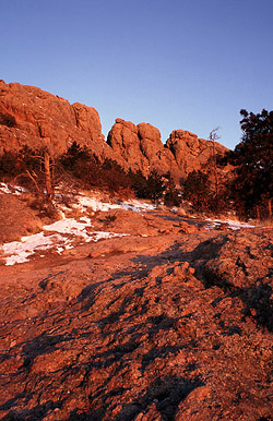
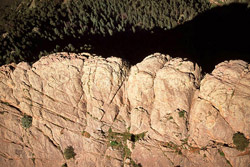
Near the solid bald
summit, the trail sort of dissappears. The correct method is to continue
north across the face of the rock, then cut west after you've passed the
"teeth" of the thing, at which point you can make it up to the tip top
provided you've brought sensible shoes. But back in 1999 I didn't know
better (because there were no really cool websites like this around to
tell me differently), and I imagined that getting to the top of the rock
required death-defying feats of rock climbing of which I was unprepared
to perform. Thus, Andra and I hiked up to the cleft between the two "teeth"
and I climbed as high as I felt I could without seriously chancing
injury (as is my usual policy in this life without health insurance) and
enjoyed the views. Indeed I managed to climb right up into the split
of the famous incisors.
After retreating
to more solid footing, Andra and I napped in the sun, lying on a bed of
windblown grass near the top. Since we were no longer moving, it was pretty
cozy temperature-wise. Blue jays and chickadees hopped and flitted
all about the crowns of the pines in search of food. Occasionally
a squirrel would scramble through the underbrush. The principal attraction,
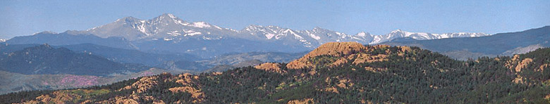
however, was the view of Fort Collins to the east. The panorama afforded
by this perch 2,000 ft above the city streets is very impressive, and the
photographs which came back with me hardly do it justice. We spent
half an hour pointing out landmarks to eachother - CSU, King Soopers, the
tree in the field behind my house, etc. To me the most prominent landmarks
in town are the twin CSU dorm towers of Westfall of Durward.
The longer we dallied
up top, the more our space was encroached upon by members of our own species.
Being generally misanthropic, I led the way as we hightailed it down in
a very short time, having the benefit of some pretty steep downhill terrain
to keep us moving briskly. Back at the car, the thermometer within
had maxed out at 120 F. Just not your typical October day.
Years later, in
January of 2003, I decided that a sunrise photograph of Horsetooth Rock
was just what I needed. Who doesn't? Accordingly, my alarm went off at
the unnatural Saturday time of 5AM. The night before I had been very excited
about getting up before dawn to hike, anxious even, but in the darkness
of my bedroom with my body cozily nestled under a thick down comforter
and flannel sheets and my mind full of knowledge about the temperature
outside (cold, damn cold), my enthusiasm waned. With supreme will power,
I clambered out of bed like a newborn gosling to peek out the window to
check for cloud cover. No luck. It was clear as a bell to the east and
the west. Stars twinkling brightly, almost like they were laughing at me.
I had no excuse for not going, and knew I'd hit myself later when the mind-altering
drug of sleepiness had worn off if I went back to bed and wasted the morning.
All these sunny days in Colorado may sound great, but when does a guy get
a solid reason to just lay in bed til 11AM watching TV, I ask you?
I turned on the lamp
and got dressed. Frank (the pointer) was still slumbering in the bed, covered
completely by the down comforter. He's great to sleep with because he's
a biological heating blanket, and boy does he throw out the BTU's. I put
on lots of warm clothes and threw my camera, film and tripod in my pack
and went downstairs. I raided the cupboard and scored a few granola bars
and a banana and filled my water bottle before zipping up my pack and donning
my outer jacket. Just as I was flipping off the lights and going out the
garage, I heard Frank's paws hit the floor of the bedroom above as he suddenly
realized that today I might be going somewhere other than work, and he
decided he should go too. Perhaps the sound of the pack zipper clued him
in, or perhaps he knew all along and was just waiting until I got through
all the formalities of breakfast before making his grand entrance. Either
way, I didn't want to have to see those pathetic eyes as I left him at
home, which I surely must do on such a fold morning, so I quickly closed
the garage door behind me and got in the car and drove off. Frank
is a very short-haired pointer. In fact, there's damn near no hair at all
on his belly and crotch. For this reason, Frank finds even mildly chilly
weather unbearable, and spends his waking hours in the sunshine or under
a blanket, and his sleeping hours under the down comforter of my bed. I
believe a pre-dawn January hike in Colorado would make him want to leave
home permanently, perhaps for Mexico.
Therefore, I was
alone as I drove west on Harmony Rd. Not a car in sight. The drive to the
trailhead took about 30 minutes, if I recall correctly, and I was dutifully
paying my $6 hiking fee (has gone up considerably since my first visit)
by about half past 6. The air was not nearly so cold as I had thought,
despite the time of year, although my breath still sent out puffs of vapor.
I shouldered my pack and took off at a good clip up the trail, not wanting
to go through all this effort and miss the first kiss of dawn on the rock.
In April 2002, I had the dissapointing experience of taking a dawn hike
to the Cirque Meadow at Pingree Park to catch sunrise on the Mummy Range,
only to arrive about 30 minutes too late. Not wanting to experience that
again, I hiked very quickly.
A woman and her dog
passed me going down the hill and in the dark the German Shepherd startled
me, although before I had time to react to his throat-ripping lunge, he
paid me no attention and cruised right past. I vaguely recalled the
route from my first hike, and I knew it was fairly steep for a the first
stretch. I tried to ignore the ache in my legs and kept up a good speed.
Before long, the cold Colorado January air began to feel more like warm
Algerian August morning air and I pulled off my knit cap and unbuttoned
my jacket.
The stars were still
visible to the west, although a slight glow began to appear in the east.
At one point, I topped a tree-free ridge and saw the entire city laid out
in front of me, all 10 million lights flickering like candles. I've
always kind of thought it was wasteful that all the car dealerships keep
their lots lit like day all night long, and from a perch like this, one
cannot mistake where the dealerships are. I suppose it's a tribute to our
great country that any American can go browse the latest foreign and domestic
auto models any time of night.
The trail wound up
and up, and the sky grew brighter. I grew warmer, warmer, and began to
feel the sweat on my chest and back. I pulled off my outer jacket and carried
it along, but did not want to take the time to take off my sweatshirt too,
so I left that on, despite it being a few degrees warmer than comfortable.
I continued on at a fast pace, but fretted that the brightening sky heralded
a sunrise that would catch me too far down the trail to photograph it.
Setting all concern for comfort aside, I hiked even faster up the quaried-rock
steps and zig-zagged through the trees, feeling sure that each bend would
put me close enough to set up a camera and shoot.
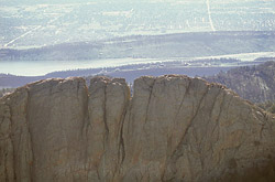
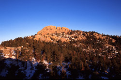
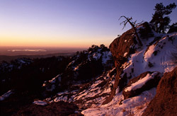
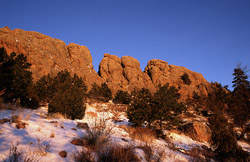
Finally, just as
I felt my last minutes of opportunity had arrived, I reached a crest and
saw the giant incisor-shaped rock to my left. I scooted up the nearest
bare rock in site, which was unfortunately farther south than I wanted
it to be, but to get a full frontal shot of the rock would've required
about 15 more minutes to hike north. I decided to go ahead and set up my
camera to be ready for the light hitting the rock. I made it just in time,
with less than 5 minutes to spare before the pinkish granite began to glow
with a redish hue. I began snapping photos and enjoying the sudden brilliant
glare to the east with the quiet city streets below. I moved my tripod
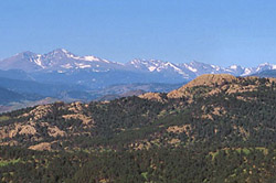
around a few times for different angles, and took a few shots of Long's
Peak to the south. I was, and still am, really amazed by some phenomenon
that made Long's Peak look a lot smaller from Horsetooth Rock than it typically
does from town. It's as if the view from Ft Collins magnifies the mountain.
Anybody know why this is?
After the sun had
risen fully, and the light had morphed from red to orange to yellow to
almost white, I packed up my gear, and began to head down. The hike back
was taken at a much more leisurley pace, as you can imagine, and I found
that I even became chilled through the shaded areas from my lack of exertion.
I met two men walking up as I neared the parking lot, but that was it.
I reached my car by about 9 o'clock, and drove back to town, stopping to
drop my film off for development on the way. This hike had all the solitude
and beauty that a nature hike should have, and skipped the mass crowds
that develop at Horsetooth Rock every weekend.
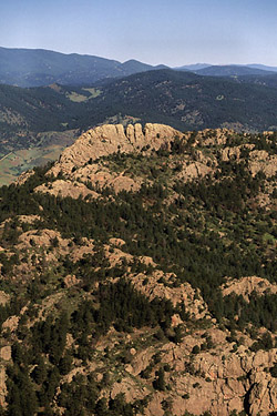
Visiting this place
at dawn is really the only way worth seeing it, in my opinion, although
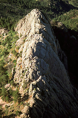
from the air is also pretty cool, as I found out in 2005 when Joe took
me for a fun ride in his small airplane right over the top of Horsetooth.
Ironically, it took
me over 10 years to finally make it to the very top of Horsetooth. Andra,
Christine and I hiked up on a wet June afternoon and managed to scramble
all the way up. I thought for sure I had taken photos of that trip, but
if I did, no photographs survive today. Perhaps the government just doesn't
want you to know what it looks like from up top.
|
 |

;)
;)
;)
;)
;)
;)
;)
;)
;)
;)