| Location:
A few miles south of Page, Arizona
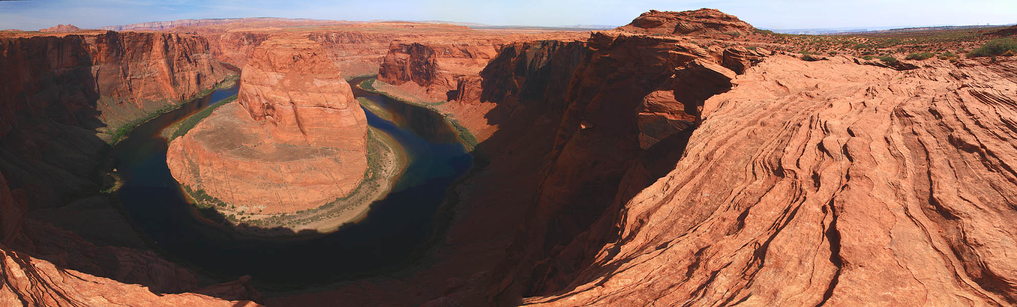
Access: From Page, AZ, drive south on Hwy 89. The turnoff for the trailhead is ~1.4 miles south of the Hwy 98 junction, on the west side of the road, and it is well-labeled. Map: USGS Ferry Swale quad Trailhead: UTM NAD83 z12 455188e 4081306n Trail: Very wide, easy, ½-mile to the canyon rim with 151 loss. No shade. Fees: None May 1, 2009 I always expect fantastic things to take a good, long time to hike to. With the exception of a few drive-up vistas brought to us by our friends at the National Park Service, Ive found this is the general rule. Therefore I was surprised to learn that the pictures in a canyon country photography book were taken no more than a mile from the highway, and only minutes from Page, at that. I checked into it on Google Earth, and there it is, just a short stroll from the parking lot. As I was planning on driving right past there on my way to Marble Canyon from Page, I decided to stop and have a look. The turnoff is well-labeled. I pulled off the blacktop and drove a bit further on and parked in a gravel lot the color of the surrounding sand and rock. A school bus was parked in the lot, as were about a dozen other passenger cars and SUVs, all with windshields glinting under a bright spring sun. I changed into walking shoes, slugged some water and started up the trail leading west over a small hump of rock. From the summit of this small hump, I could see west for 50 miles, across an ocean of reddish-pinkish rock mesas, cliffs and bare rock swells. Very little green to this view, thats true. The Vermillion Cliffs topped the horizon, with nothing above but thin, vaporous white clouds. The trail was very wide and easily-navigable, and I strolled downhill with gravity as my guide, past half a dozen groups of kids, all on their way back up to the school bus, probably. In no time I was at the canyon rim, overlooking a great bend in the Colorado River. Very distinctive. Very photogenic. The cliff on the far side of the river, corresponding to the cliff I stood on, had been cut away on both sides by the river, till only a thin peninsula of the strata remained. The scene reminded me a lot of Echo Park in Dinosaur National Monument, where the Green River similarly curls around, and eats away at, Steamboat Rock. For such a simple walk, its a pretty impressive sight. |
;)
A short walk across open sandy scrub gets you to the rim ;)
The Vermillion Cliffs in the distance, deep canyon in between
|
;)