August 15,
2007
Rain poured down in sheets
outside the open windows of Moms apartment and I sulked. This was the
day we were supposed to start our backpacking trip, and the weather had
not cooperated. Someone didnt get my order for clear skies and sunshine,
did they? I packed slower than usual, not looking forward to the long drive
in the rain. We left Manchester at 8, and drove north on I-93 into the
White Mountains. In an hour, the rain stopped, and the sun actually poked
out behind ragged clouds. We stopped in Lincoln and bought a Mt Washington
quad map at a small bookstore on Main St, then continued north to Highway
3, where we broke off and drove northeast to Gorham, then south on Route
16 to Pinkham Notch. A hundred cars were parked at Pinkham Notch, but we
didnt remain there too long. We hoisted our packs under the increasingly-sunny
sky and started hiking the Old Jackson Rd at 11:00. In fact, this was only
Moms 2nd experience with a frame pack, and this one she had purchased
at deep discount at an EMS used goods sale. It was grossly oversized for
her. It was grossly oversized for me, too. She shouldered the hulking red
pack as best she could, cinching the straps way down to improve the fit,
even to the point where they couldnt be tightened any further. The hip
belt, for example, was tightened to as small a circumference as possible,
and still required her to wrap a sweatshirt around her waist to hold it
up. This was a very big pack. We walked north under a canopy of maples
and hemlocks with tiny flecks of sunlight splashing on the trail. I was
wrong to have fretted about the morning rain, and I grew very happy to
be on the trail again.
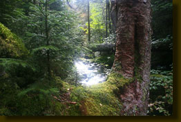
The western woods are a whole
different world than this. Im used to the wide, open parks and thinly-spaced
pines. The density of tree trunks here overwhelms the senses, and I was
unceasingly surprised at how many streams we passed over. The AMC White
Mt Guide definitively gives the distance to the Mt Washington Auto Rd as
1.5 miles, and we could hear cars laboring up the steep grade long before
we crossed it. Continuing north, the Madison Gulf Trail took us into the
Great Gulf Wilderness, a name I am very fond of, and into the bowl of the
Presidential Range. The Great Gulf is one of the original wilderness areas
designated by the Wilderness Act of 1964. Though the forest prevented seeing
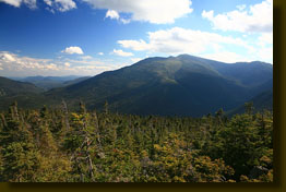
the full range all at once, I caught glimpses of Mt Washington, Clay, Jefferson,
Adams and Madison to the west. All were extremely high, and unseemingly
close. Another difference between east and west: Mountains in the east
are packed very close together. Within a couple of hours of leaving Pinkham
Notch, we reached the Peabody River, and the junction of the Madison Gulf
and Great Gulf Trails. We retreated upslope into the woods and scouted
for a campsite. I was thus exposed to another stark difference between
east and west mountains: Flat campsites are very hard to find in the east!
We looked for 20 minutes or so before settling on a decent but sloping
area between two massive tree roots. It was a little small, but at least
there were not trees poking through the ground, or giant boulders to contend
with. We set up the tent and had a nice lunch. The sun was still out and
the sky was an unbroken blue.
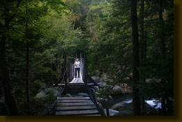
Refreshed, I loaded my pack
with only a few essential items, and we crossed the Peabody River on a
suspension bridge and started up the relentless Osgood Trail toward Mt
Madison. We passed an established camp that I hadnt known about that had
nice, flat spots that were already claimed by about 6 tents all set up
close together. Didnt look like my kind of camp, anyway. The grade
of the Osgood Trail was steep, and for long stretches untold thousands
of boulders had been embedded in the slope to form a stairway. I am awed
by the amount of work this must have taken. Many of the trails in the Great
Gulf were cleared before 1900. In almost no time we were high above the
valley bottom, looking down over a sea of green trees, with Mt Washington
looming like a presence above all. I felt the humidity press in, and sweat
dripped off my nose. The wildness of these woods is fantastic, and that
old sweet taste of adventure came to me as I looked across the deep ranks
of dark trees, clawing against eachother toward the light. In places along
the trail the canopy was so thick that nothing grew on the ground at all.
We passed only a few people
on the hike, all coming down. Overall, it was very quiet and felt very
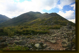
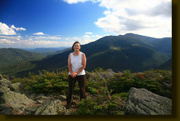
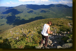
deserted. The afternoon waned as we finally broke through treeline and
began to enjoy unbroken views of the mountains around us. The trail continued
for some time up through stunted spruce trees no more than 3 feet tall.
I sampled some of the tiny blueberries growing in the rocks along the trail.
Across Rt 16, we could see the timber-free strips of Wildcat Ski Area running
down the mountain like rivulets of water. By 5:00, we were still ½
mile short of the Mt Madison summit, though it was clearly in sight, and
decided to turn back to ensure we were at camp before dark. The walk back
down was, naturally, very easy, and we made it back in about the half the
time it took to get up. Thus it was that by 6:00, we were near camp eating
dinner of lasagna and chocolate cheese cake
both outstanding. Afterward,
I pulled some water from the river and brought it uphill near camp and
heated it up to provide a nice sponge bath that was required after the
sweaty trek up the Osgood Trail. It was dark pretty early (8:15) in this
eastern bowl, especially in the thick woods, and we were in the tent by
8:30. I was initially very hot in the tent, but within an hour, rain came
and cooled things off. I slept fairly well, despite the sloping tent.
August 16
I was vaguely awakened at
6:00 by Mom leaving the tent. I slept for another hour and then got up
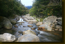
as well to join Mom down by the rushing waters of the Peabody River, the
West Branch of the river, to be precise. We ate a cold breakfast of raspberry
granola, and then took off west on the Great Gulf Trail under completely
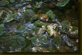
overcast skies. It was cool, and wet, and I slipped several times on wet
rocks and mossy logs. Vibram soles are useless on wet logs. The path followed
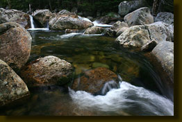
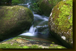
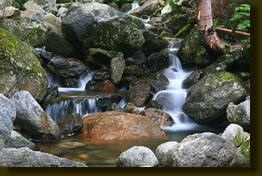
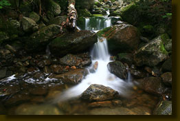
the south side of the river for a couple of miles, and we were treated
to the constant rush of river water over boulders and logs, forming hundreds
of tiny falls along the way. As the morning drew on, the sun came out in
spots and warmed things up. We stopped frequently to sit on boulders in
the river and enjoy the water show. By the time we reached the Chandler
Brook turnoff, the clouds had rolled in heavy, and did not leave. About
2 hours after leaving camp, we started on the Six Husbands Trail. I was
amazed at how many intersecting trails there are in this area. You really
have to keep your trailmap handy or youll miss your exit! We hiked up
the narrow and apparently little-used Six Husbands Trail. Evergreen boughs,
heavy with water from the nights rain, brushed against my legs and arms,
depositing the water on me and soaking me in no time. Before long, the
trail became so obscure that we backtracked a little to make sure we hadnt
missed a turnoff. The trail was only a narrow path that looked more like
a natural drainage. We did, however, see that someone had recently chopped
a few branches out of the way, so assumed we were still on the correct
route. We reached a particularly steep rockface that had no way around.
I shucked off my pack and carefully inched my way up the sloping rock face,
a task that would be almost impossible with a pack on. At the top, I walked
ten more feet and was confronted with another rock face with no apparent
trail or way around the rocks. I was baffled. Mom was clearly not comfortable
with pressing on, and frankly, neither was I. We agreed to leave Mt Jefferson
for another day, and returned the way we had come. Looking through openings
in the forest, we could see that the mountains were cloaked in heavy cloudcover
anyway, so what would we have seen had we made it to the summit?
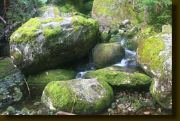
We took a sidetrip up scenic
Chandler Brook and took our time back to camp. When we arrived at 1:00,
we snacked on granola and nuts, then decided to check out other camp opportunities
since neither of us was thrilled with the sloping spot we now occupied.
The Osgood camp across the river was more packed than ever, with more than
half a dozen tents set up. The Osgood Trail is part of the Appalacian Trail,
so I assume many of these tents belonged to through hikers. We had passed
another flat camp area up the river on the Great Gulf Trail earlier, but
it was right on the trail, and in the wrong direction of where we ultimately
wanted to go, so we decided to take a chance and pack up and move
south. Packing up took little time, and we were soon heading back towards
Pinkham Notch, eyeing the woods carefully for potential campsites (read:
flat, no trees). We stopped often to scout the woods off-trail, but found
no decent spots. I had never been confronted with such a problem while
camping in the west, and I wondered how people deal with it. My own plan
for dealing with it in the future is by bringing along a hammock to sleep
in. OK, so we kept going, and going, looking, and going, and finally we
were back at Pinkham Notch around 6:00 without ever having found any spot
to pitch the tent. This wasnt planned, but what can you do? I asked the
fellow at Pinkham Notch Info Desk if there were any places we could hike
a short ways in and camp. He was decidedly unhelpful, offered no tips at
all and his tone dripped with condescension at my even having asked. He
even managed to work in a shot lecture about how the forest is overused
and people dont treat it right, seemingly aiming it at me for wanting
to camp somewhere. He shouldnt be working at an info desk if he has a
problem with people hiking and camping in his beloved woods. By perusing
a wall map of the area, I spied the big Dolly Cop campground just up the
road. Car camping was not preferred, but it was at least an option at this
late hour. We hopped in the car, drove up the road, and paid our $20 for
a campsite which functioned fine for a good-nights rest. The place was
relatively full, but overall pretty quiet. Our camp was situated in the
lesser-traveled tents-only section, with plenty of trees around. My only
complaint was the strange fellow in the next camp who started chopping
wood at 4:40 AM, a full hour before it even began to get light out. Fortunately,
I was extremely tired, and was only awake for the second it took me to
check the time.
August 17
Up and packed by 7, we trucked
on north and stopped for coffee in Gorham before heading west for Acadia
National Park. |
|
;)
;)
;)
;)
;)
;)
;)
;)
;)
;)
;)
;)
;)
;)
;)