 Andra
and I spent five days in August 1999 backpacking through lush forests and
over rocky tundra as we made our way from camp to camp in the southeastern
corner of Glacier National Park. Camps in this park are designated, although
with enough paperwork, one can obtain a truly backcountry permit. Ours
was of the pseudo-backcountry kind: we had to hike, but there was an outhouse
there when we arrived, as well as designated campsites and cooking areas.
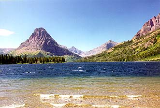
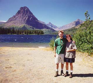
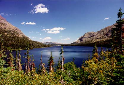
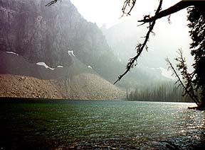
The trek began at 10 in the morning with a 20 minute boat ride across Two
Medicine Lake, a very deep (250 ft) dark blue oval shaped body of clear,
cold mountain water. The Lake was 2.5 miles across, and it saved us at
least that much hiking that first day. Not bad for $4. Plus, it was fun.
I dont get on boats very often. The boat docked on the western edge of
the lake, and let everyone off who wanted to get off (some appeared deathly
afraid of stepping off any man made surface). Andra and I were the only
ones without return tickets.
Andra
and I spent five days in August 1999 backpacking through lush forests and
over rocky tundra as we made our way from camp to camp in the southeastern
corner of Glacier National Park. Camps in this park are designated, although
with enough paperwork, one can obtain a truly backcountry permit. Ours
was of the pseudo-backcountry kind: we had to hike, but there was an outhouse
there when we arrived, as well as designated campsites and cooking areas.
The trek began at 10 in the morning with a 20 minute boat ride across Two
Medicine Lake, a very deep (250 ft) dark blue oval shaped body of clear,
cold mountain water. The Lake was 2.5 miles across, and it saved us at
least that much hiking that first day. Not bad for $4. Plus, it was fun.
I dont get on boats very often. The boat docked on the western edge of
the lake, and let everyone off who wanted to get off (some appeared deathly
afraid of stepping off any man made surface). Andra and I were the only
ones without return tickets.
The day was bright and sunny, with a few puffy
clouds dotting the deep blue sky: exactly as I had seen it in my dreams
since I made our campsite reservations 7 months before. My friend in Plant
Morphology tried making reservations two weeks after I had made mine, but
was denied. Apparently, you must reserve quite early for the choice sites.
Immediately after we hit the shore, I paused
for a few moments to invest in foot care. Moleskin that is. Very effective
stuff. I treat it as insurance against blisters, and I don't think I'll
every take a trip without it. Good stuff. The trail was made of dark brown
packed soil, with jungles of waist high ferns on either side. Most of the
way was sheltered by towering firs and spruces, but occasionally we came
into an area free of overhanging shadows, where flowers grew in abundance.
The trail led past a pinnacle of rock called Pumpelly pillar, named after
a well-traveled western geologist who explored many parts of the area.
 We
passed several people along the way, more than I'd expected to encounter,
but most turned back when they reached Twin Falls, about a mile from the
lake. Twin Falls itself was tall, but at this dry time of year, not very
impressive. I have no doubt that in early summer it is a sight to behold.
We slowly crept upward toward Upper Two Medicine Lake and nibbled at huckleberries
and thimble berries along the way. Very tasty. Bears think so too.
We
passed several people along the way, more than I'd expected to encounter,
but most turned back when they reached Twin Falls, about a mile from the
lake. Twin Falls itself was tall, but at this dry time of year, not very
impressive. I have no doubt that in early summer it is a sight to behold.
We slowly crept upward toward Upper Two Medicine Lake and nibbled at huckleberries
and thimble berries along the way. Very tasty. Bears think so too.
Before we even had time to break a sweat, the
campsite appeared before us. We studied the diagrammatic map of the camp
layout: food hanging area-first right, food prep area-first left, latrine-second
right, four campsites, up to the left and toward the lake. We scouted out
each campsite one by one. I was a little dismayed to see how closely the
campsites were situated. Some good snoring could easily find its way into
every tent should the wind die down at night. I appreciate the park service
attempting to mitigate heavy tourist volume, but did they have to make
it like a KOA? I backpack partly because I can't stand to be around a dozen
other humans at a designated site, and walking five miles away from the
nearest road is your best chance to find yourself alone. Am I just cranky?
A curmudgeon at age 22? We had a nice afternoon reading in various places:
by the south shore of the lake on large rocks jutting out over the water,
on the north side of the lake on the gravel beach, in the tent, you know,
all the typical places of beauty. I was reading AIRFRAME, and Andra was
busily reading Palindrome. I found it hard to read at all with the natural
distractions. I just couldn't reconcile myself to traveling 700 miles to
sit in a national park and read a book. So I did little reading, and much
staring at the lake and the immense cliffs surrounding it. I threw
a line with a hook attached to the end into the water, but nothing came
to taste it. I am terrible at fishing, and that's probably why I stopped
purchasing a fishing license 3 years ago. Just not worth it. If I ever
figure up the amount of money in license fees I've paid for each fish I've
actually caught, I'm sure I will find those fish somewhere in the price
range of caviar. No license is required to fish in Glacier Park, so I fished.
 We
ate pasta cooked over a white gas stove that evening in the designated
food prep area. I think it is designated merely to save the marmots the
trouble of walking from camp to camp to beg for food. This way, they can
solicit a larger audience with a fraction of the effort. Pretty sweet system
they got there. Watch your food, they're sneaky. Surprisingly, we were
the only group cooking. The other 4 groups contented themselves with jerky,
crackers, sausage and granola. Snackfood. I need something hardy, you know,
something with healthy doses of MSG and sodium benzoate.
We
ate pasta cooked over a white gas stove that evening in the designated
food prep area. I think it is designated merely to save the marmots the
trouble of walking from camp to camp to beg for food. This way, they can
solicit a larger audience with a fraction of the effort. Pretty sweet system
they got there. Watch your food, they're sneaky. Surprisingly, we were
the only group cooking. The other 4 groups contented themselves with jerky,
crackers, sausage and granola. Snackfood. I need something hardy, you know,
something with healthy doses of MSG and sodium benzoate.
I slept wonderfully that night, and awoke at 7:00
to try my hand at early morning fishing, although, admittedly, the prospect
of fish for breakfast didn't provide a lot of motivation. Nevertheless,
I stepped out of the tent after noisily getting dressed amid the tired
growls of my tentmate, only to find that dense clouds lined the valley,
obscuring the surrounding peaks and casting a cold gloom over the forest.
I suddenly missed my warm sleeping bag in the dark tent. I feared getting
back into the tent so soon, lest my tentmate find a weapon of some sort,
so I grabbed my pole and headed for deep water. After an hour of shivering
and freezing my butt off by the lakeshore, I hastened back to the tent:
I'm only a mountain man if the sun is shining, Ill admit that. The clouds
were still low and gray, although every once in a bit I managed a glimpse
of the surrounding peaks through holes in the veil above. Back in the tent,
I warmed myself up in my bag, and the next thing I knew, it was 11:00,
and Andra was awake, reading her book. I panicked with the thought of having
to cover 6 miles and not even having gotten out of bed by 11. I hurriedly
got dressed and prepared oatmeal for breakfast. By this time the clouds
were gone, and the golden sun heated up the area real quick. We managed
to pack up and leave camp by noon, after which point my unease about getting
such a late start abated somewhat. It seems ironic that even on vacation,
I was concerned with keeping a schedule. If the Park Service allowed more
freedom to pick campsites, there would have been no sense of urgency. Camping
in national forests seems much more to my liking since you can camp wherever
and whenever you like....and it's free.
We backtracked the trail we had come up the day
before until we hit a Y intersection, and took the road not yet traveled.
We passed through more dense fern lowlands, very quiet and cool, and eventually
emerged from the forest onto a sharply sloped plain of tall flowers and
berry bushes, from which we could see that we were about a hundred feet
above Two Medicine Lake on the southwest shore. We continued to hike along
the lakeshore, gradually gaining elevation, until we reentered the forest
and the lake was lost from view. The huckleberries along this stretch
of the trail were especially numerous and delectable.
 Glacier
National Park was created by Congress in 1910, and the bill was signed
into law by Teddy Roosevelt, the arch-conservative Republican who seems
to bear absolutely no resemblance to the arch-conservative Republicans
of today. Somewhere along the way the GOP dropped environmental stewardship
as part of their mantra, and thats really too bad for everyone. The park
was first explored by prospectors looking for copper or oil. A copper mine
was started near Cracker Lake, and the Butte Oil Company continued to search
for the fabled oil reserves near Kintla Lake until 1912. Many Glacier Valley
was a mining town in 1900. Bailey Willis of the USGS took an interest in
correcting perceived errors in the US-Canadian border (49th parallel) that
was laid down in 1874, so he put together a team of geologists, paleontologists
and packers and set out to remark the border in 1901. Over the course of
three months, the team explored most of the northern section of todays
Glacier National Park, and photographs Bailey took seemed to provide the
sensational advertisement necessary for Congress to create the Park. At
age 81, Willis declared that his photographs "played an important part
in the argument for a national park
.back in Washington the photographs
taken by my good camera conveyed the beauty of the mountains and canyons
so vividly to President Roosevelt that he realized what the grandeur would
mean to the nation as a park for their enjoyment for all time to come."
Thank you, Mr. Willis.
Glacier
National Park was created by Congress in 1910, and the bill was signed
into law by Teddy Roosevelt, the arch-conservative Republican who seems
to bear absolutely no resemblance to the arch-conservative Republicans
of today. Somewhere along the way the GOP dropped environmental stewardship
as part of their mantra, and thats really too bad for everyone. The park
was first explored by prospectors looking for copper or oil. A copper mine
was started near Cracker Lake, and the Butte Oil Company continued to search
for the fabled oil reserves near Kintla Lake until 1912. Many Glacier Valley
was a mining town in 1900. Bailey Willis of the USGS took an interest in
correcting perceived errors in the US-Canadian border (49th parallel) that
was laid down in 1874, so he put together a team of geologists, paleontologists
and packers and set out to remark the border in 1901. Over the course of
three months, the team explored most of the northern section of todays
Glacier National Park, and photographs Bailey took seemed to provide the
sensational advertisement necessary for Congress to create the Park. At
age 81, Willis declared that his photographs "played an important part
in the argument for a national park
.back in Washington the photographs
taken by my good camera conveyed the beauty of the mountains and canyons
so vividly to President Roosevelt that he realized what the grandeur would
mean to the nation as a park for their enjoyment for all time to come."
Thank you, Mr. Willis.
For the next few miles, we walked along in the
cool shade of the pines, meeting more people along the way, and growing
more annoyed by the incessant and arguably ineffective jangling of bear
bells tied to various parts of bodies walking past. We contented ourselves
to let everyone else scare the bears off, and saved ourselves the trouble.
As I had not bothered to put on any sort of deodorant, I anticipated the
bears would smell me coming long before I noted their proximity. Unexpectedly,
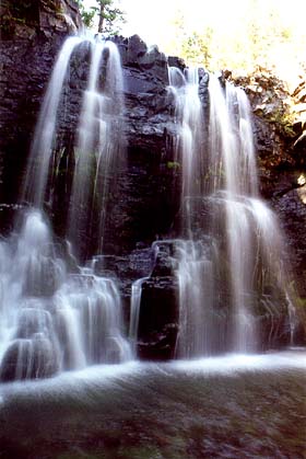
we came upon Rockwell Falls, a wonderful 30 foot rock ledge spewing water.
After hiking in the windless forest for so long, the cool mist spraying
out from the falls was very refreshing. We had our lunch there in the deep
shade by the rippling water.
 The
trail got very steep after Rockwell Falls. We were by then anxious to get
to camp. We met an old German couple who claimed it was "only a few more
minutes to the lake", but 40 minutes later we were still wondering where
it was. Is that supposed to be encouraging, lying to someone about how
far it is? I'm not a big fan. Just a few hundred yards before we walked
to Cobalt Lake's rocky shores, dozens of people came down the narrow trail
from the lake, including a park ranger. We stood to the side while they
filed past, many of them stopping to tell us all about the two grizzlies
swimming in the lake a few hours earlier. Just missed them!
The
trail got very steep after Rockwell Falls. We were by then anxious to get
to camp. We met an old German couple who claimed it was "only a few more
minutes to the lake", but 40 minutes later we were still wondering where
it was. Is that supposed to be encouraging, lying to someone about how
far it is? I'm not a big fan. Just a few hundred yards before we walked
to Cobalt Lake's rocky shores, dozens of people came down the narrow trail
from the lake, including a park ranger. We stood to the side while they
filed past, many of them stopping to tell us all about the two grizzlies
swimming in the lake a few hours earlier. Just missed them!
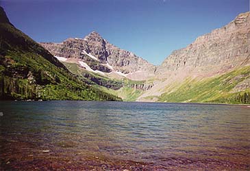
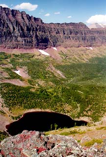
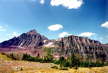
Cobalt Lake was significantly smaller than Upper
Two Medicine. I say that as neither a compliment nor an insult. Every lake
we saw was beautiful in its own way. Cobalt Lake had a personality which
was more cold and barren. The shores were rocky and the trees growing about
the lake were small and stunted, owing to the proximity to treeline. The
southern shore consisted of a rock wall rising over a thousand feet above
the lake. On the shore, sitting in perpetual shadow, was a large field
of snow, with a curious hole near the bottom as if a bear might lumber
out at any moment. Did we really miss Grizz?
Cobalt Lake had only two campsites rather than
four, and the entertaining group of three that occupied the other site
regaled us at dinner with the story of their bear encounter on Two Medicine
Pass. Two Medicine Pass is at the top of the 1000 ft wall directly behind
Cobalt Lake. While trekking toward Cobalt Lake from the other side of the
pass earlier in that day, the group had been spotted by the two grizzlies
of previous fame, and were forced to leave the trail after being charged,
almost playfully it sounded, by one of the bears. Up on the pass, there
is no cover, no trees, no large rocks, and steep cliffs on either side.
I didn't envy their encounter, but I envy the story they'll be able to
tell friends back home.
 The
next morning I awoke with very cold feet. I got up if for no other reason
than to put socks on, and stepped out of the tent. The sky was clear as
a bell, but the sun was still rising behind the 1000 ft wall that also
ran to the east of our camp. Anticipating the long hike ahead to Lake Isabel
on the other side of the pass, we got up and, moving quickly, made breakfast
and packed up camp all before 9:30. The sun had still not hit our camp
by then, and we walked in chilly shadow for the first ten minutes. The
trail climbed steeply to the west, and before long we stopped to change
clothes and rest in the last clump of stunted spruce until the other side
of the pass. The sun became very hot indeed as we labored up the ridiculously
steep slopes toward the pass. Often I found my boots slipping down on the
loose gravel, or my walking stick catching no grip as I leaned on it, so
steep was the angle of our ascent. It was laboriously slow going, and Andra
was in no mood for such hard work so early in the morning. We made our
way slowly up the west side of the ridge, and three hours later, we were
looking down on Cobalt Lake from a bird's eye view. We could even see our
campsite and the pit toilet. We continued along the ridge, noting with
a bit of disappointment the smoke-filled air. Fires were raging over most
of western Montana, with one near Kintla Lake inside the park to the northeast.
Visibility was severely reduced, and the sunlight filtered through in an
unnatural pink hue. From the top of the ridge, we could see Lake Isabel,
our destination, perched in a hanging valley not very far away. The problem
was that the hanging valley was not too much lower than where we were currently
at, but to get there, we first had to go the valley bottom 2000' feet below,
then come back up. I wasn' t the only one a little unhappy to see what
was in store.
The
next morning I awoke with very cold feet. I got up if for no other reason
than to put socks on, and stepped out of the tent. The sky was clear as
a bell, but the sun was still rising behind the 1000 ft wall that also
ran to the east of our camp. Anticipating the long hike ahead to Lake Isabel
on the other side of the pass, we got up and, moving quickly, made breakfast
and packed up camp all before 9:30. The sun had still not hit our camp
by then, and we walked in chilly shadow for the first ten minutes. The
trail climbed steeply to the west, and before long we stopped to change
clothes and rest in the last clump of stunted spruce until the other side
of the pass. The sun became very hot indeed as we labored up the ridiculously
steep slopes toward the pass. Often I found my boots slipping down on the
loose gravel, or my walking stick catching no grip as I leaned on it, so
steep was the angle of our ascent. It was laboriously slow going, and Andra
was in no mood for such hard work so early in the morning. We made our
way slowly up the west side of the ridge, and three hours later, we were
looking down on Cobalt Lake from a bird's eye view. We could even see our
campsite and the pit toilet. We continued along the ridge, noting with
a bit of disappointment the smoke-filled air. Fires were raging over most
of western Montana, with one near Kintla Lake inside the park to the northeast.
Visibility was severely reduced, and the sunlight filtered through in an
unnatural pink hue. From the top of the ridge, we could see Lake Isabel,
our destination, perched in a hanging valley not very far away. The problem
was that the hanging valley was not too much lower than where we were currently
at, but to get there, we first had to go the valley bottom 2000' feet below,
then come back up. I wasn' t the only one a little unhappy to see what
was in store.
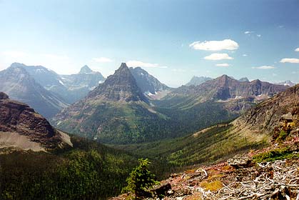
 We
continued on along the ridge, following the dotted line of the continental
divide on the map and summited 7700' Chief Lodgepole Peak. At that point
we had climbed 2800' from the shore of Two Medicine Lake. Interestingly
enough, we could see the parking lot where we began two days earlier to
the northeast 5.5 miles, and the furthest point of our trek, Lake Isabel,
3 miles to the southwest. Those distances are line of sight only; by foot,
we were much further away. From this perch, the surrounding peaks jutted
up clearly on the horizon. I love the names: Sinopah, Painted Teepee Peak,
Grizzly Mountain, Eagle Ribs Mountain, Mt. Despair, Appisoki Peak, Never
Laughs Mountain, Vigil Peak, Church Butte, Statuary Mountain, Red Crow,
Bearhead, Battlement Mountain, Caper Peak, Lone Walker Mountain, and to
the far north, the highest peak in the park, Rising Wolf. Dave and I once
had a discussion about why some mountains are named peaks and some are
named mountain, and furthermore, why some have Mount before the name, and
others have Mountain after the name. Our conclusion: whatever sounds best
goes. Pike's Peak sounds better than Mount Pike. And so on.
We
continued on along the ridge, following the dotted line of the continental
divide on the map and summited 7700' Chief Lodgepole Peak. At that point
we had climbed 2800' from the shore of Two Medicine Lake. Interestingly
enough, we could see the parking lot where we began two days earlier to
the northeast 5.5 miles, and the furthest point of our trek, Lake Isabel,
3 miles to the southwest. Those distances are line of sight only; by foot,
we were much further away. From this perch, the surrounding peaks jutted
up clearly on the horizon. I love the names: Sinopah, Painted Teepee Peak,
Grizzly Mountain, Eagle Ribs Mountain, Mt. Despair, Appisoki Peak, Never
Laughs Mountain, Vigil Peak, Church Butte, Statuary Mountain, Red Crow,
Bearhead, Battlement Mountain, Caper Peak, Lone Walker Mountain, and to
the far north, the highest peak in the park, Rising Wolf. Dave and I once
had a discussion about why some mountains are named peaks and some are
named mountain, and furthermore, why some have Mount before the name, and
others have Mountain after the name. Our conclusion: whatever sounds best
goes. Pike's Peak sounds better than Mount Pike. And so on.
As hard as the ascent up the pass was, the trip
down was even more difficult. My feet had remained blister-free up to that
point, but not even my friend moleskin could help my feet as they squished
and pushed against the toes of my boots on the steep switchbacks going
down for miles. I could feel the blisters forming on my toes and heels.
Try to ignore it. Eventually, after 4 switchbacks, we were back below treeline,
even though the majority of the trees were skeletal remains only. We ate
lunch in the shade of a few tall spruces and continued on the way down.
 The
hike became more pleasant as the trail faded from stark, rock trails to
lush wet lowlands filled with ferns and huckleberries. All around
us birds sang, water crackled and whispered in the streams, and sunlight
filtered through the trees in patches, no longer quite so blotched out
by smoke. We stopped at the first water we crossed, having long since drained
our bottles, and filtered water. Plump tadpoles and anomalous grey, crusty
slow-moving "things" inhabited the water. It tasted very good.
The
hike became more pleasant as the trail faded from stark, rock trails to
lush wet lowlands filled with ferns and huckleberries. All around
us birds sang, water crackled and whispered in the streams, and sunlight
filtered through the trees in patches, no longer quite so blotched out
by smoke. We stopped at the first water we crossed, having long since drained
our bottles, and filtered water. Plump tadpoles and anomalous grey, crusty
slow-moving "things" inhabited the water. It tasted very good.
After awhile we were walking along a large creek,
several dozen feet above it, and were treated to nice aerial waterfall
views along the way. Without much fanfare, we passed into the Park Creek
campground at the valley bottom where the creek we had followed joined
Park Creek. A quaint old ranger patrol cabin sat at the trail marker, with
bright yellow NO TRESPASSING posters adorning every conceivable entry.
The trees here were enormous, and the surrounding vegetation was extraordinarily
lush. Without stopping to rest, we continued up the last leg to Lake Isabel.
Andra and I later talked about our favorite parts
of the trip, and I recalled that the hike up to Lake Isabel from Park Creek
was mine. The hike to that point had taken the better part of the day,
and we trudged up the overgrown mountainside of Vigil Peak in the late
afternoon sun. I love late afternoon sun in the summer, no time else is
the light so orange and warm. It bathed the leaves around us in orange
speckles, and sent shafts of bronze light streaking in all directions through
squinted eyes cast up at the horizon we were walking into. We were 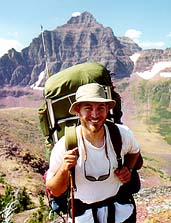 exhausted,
but happy that we had come so far, over such elevation, and were now so
close. The pain seemed to melt away from my legs and feet, and we talked
quite a bit, in contrast to our silent trek over the pass. Like a dream.
In addition, we knew at that point that we were too far from a parking
lot to see anybody but the other people camping at the lake, which was
bound to be less than 2, and knowing how far from civilization and asphalt
we were lent a tang of barbarism to the whole event. Lovely thing to be
out in the forest far from anything. That was my favorite part of the trip,
right there. The paradox that flittered across my thoughts was that I enjoyed
the trail immensely, yet I was immensely anxious to reach the lake.
exhausted,
but happy that we had come so far, over such elevation, and were now so
close. The pain seemed to melt away from my legs and feet, and we talked
quite a bit, in contrast to our silent trek over the pass. Like a dream.
In addition, we knew at that point that we were too far from a parking
lot to see anybody but the other people camping at the lake, which was
bound to be less than 2, and knowing how far from civilization and asphalt
we were lent a tang of barbarism to the whole event. Lovely thing to be
out in the forest far from anything. That was my favorite part of the trip,
right there. The paradox that flittered across my thoughts was that I enjoyed
the trail immensely, yet I was immensely anxious to reach the lake.
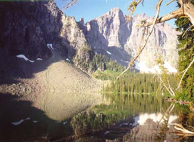
Lake Isabel was much larger than Cobalt, and entirely
different. Trees grew right up to the shoreline, making strolls around
the lake difficult. The campsite was situated among an incredibly dense
thicket of huckleberry, cow parsnip and delphinium, and the individual
campsites themselves were spaced very far apart, much more to my way of
preference. A lone hiker was at the lake when we arrived, a Czech man named
Steven, not much older than I. He was on a six day trip through the park
alone, and seemed like a very nice man. Andra pointed out that perhaps
the reason I thought he was so nice was that he wasn't able to talk enough
(in English) to make me dislike him. Good point. It's hard to offend if
you keep your trap shut. He pointed out a moose wading in the water, and
we walked down to the shore to see, scaring it off in the process. We talked
little at the food prep area as we each cooked our meals, and it was a
very nice calm, quiet evening. The moment lived autonomously by that lake,
with the longest term goal being to hang up the food after dinner. Nothing
beyond the moment mattered, and that is a concept that simply can't coexist
with the soot-stained city life most of us are trapped in now. It was the
essence of simplicity: Smiles around the 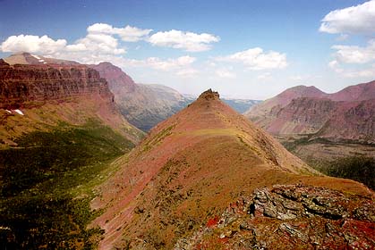 hissing
cook stove, evening light, sitting on logs and sipping water with a meal,
the gentle lap of waves on the rocky shore, towering rock walls catching
the last light of the setting sun and blazing orange in a brilliant, luminescent
blue sky. All out here beyond the wall. Such stuff as dreams are made on.....mine
anyway.
hissing
cook stove, evening light, sitting on logs and sipping water with a meal,
the gentle lap of waves on the rocky shore, towering rock walls catching
the last light of the setting sun and blazing orange in a brilliant, luminescent
blue sky. All out here beyond the wall. Such stuff as dreams are made on.....mine
anyway.
We had no problem falling asleep that night. The
next morning came quickly it seemed, for I was not plagued by the usual
frequent awakenings I so often experience when camping. The light was shining
on the tent in spots, and another clear blue sky greeted us as we unzipped
the rainfly to peer out. We decided not to cook, since neither of us was
all that hungry, and instead snacked lightly on crackers and granola. This
allowed us to pack up camp and hit the trail earlier than usual, and we
parted from the shore of Isabel shortly before 9:00. My last view of the
lake was filled with rising fish on a plate-glass surface. If only I had
more time to fish!
Steven had left a quarter hour ahead, but we caught
up to him at the Park Creek Bridge, and then he disappeared from the trail
and had to have been behind us since I caught several hundred spider webs
in the face along the trail. The sky was not filled with smoke as it had
been the previous morning, and a steady wind cooled the sweat from our
backs (which left salt deposits that looked like bleach accidents). The
hike up to the pass was very difficult, but we were in better spirits,
so with frequent stops, we slowly made our way up through the 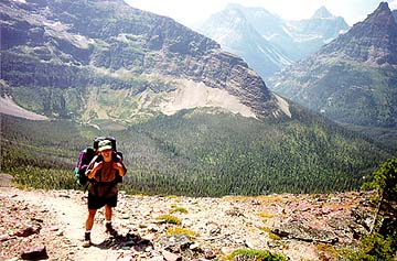 thick
underbrush, snacking on berries the whole way, and spotting the signs of
bears who had snacked on berries as well. We stopped at the last water
crossing to fill up before getting above tree line. Soon we were treated
to ever-more impressive views as we ascended higher up the ridge. I counted
the switchbacks as we went up, all seven, and was delighted to finally
reach the top of the ridge where we could finally look forward to downhill
(although, again, curiously, downhill is even more painful). We sat and
ate lunch on the top of the ridge with a panoramic view of the valleys
around us. The visibility was very much improved form the day before.
thick
underbrush, snacking on berries the whole way, and spotting the signs of
bears who had snacked on berries as well. We stopped at the last water
crossing to fill up before getting above tree line. Soon we were treated
to ever-more impressive views as we ascended higher up the ridge. I counted
the switchbacks as we went up, all seven, and was delighted to finally
reach the top of the ridge where we could finally look forward to downhill
(although, again, curiously, downhill is even more painful). We sat and
ate lunch on the top of the ridge with a panoramic view of the valleys
around us. The visibility was very much improved form the day before.
After a few more uphill pushes, we began the steep
downhill descent to Cobalt Lake. Toward the end of that trail, we became
very anxious to get to camp, and it didn't come soon enough. The tricky
thing there is that you can see the lake when you're still 2 miles away,
so it takes a lot longer than you think to get there. We rolled into camp
a lot earlier than the previous day, and by now we had our whole system
efficiently worked out. We grabbed everything we'd need for dinner, plus
our books, and went to the lakeshore, stopping to hang our food along the
way. An older couple rolled into camp and talked with us about how far
it was to the Park Creek Campground from here. Andra and I listened in
disbelief to their plans to continue on over the pass so late in the afternoon,
by then being nearly 5:00. As it had taken Andra and I 6 hours to make
the same hike, fresh, we were pretty convinced they had no chance of making
it before dark. As much as I hate unprepared backpackers, we invited them
to share our site for the night, and continue on in the morning (campsites
are reserved in advance, and they hadn' t done that). We lounged
by the lake and soaked our feet and legs in the icy water, and read our
books on this great large rock ten feet from shore that can only be accessed
by wading out to it. The sun shone low on the rocky horizon, glinting on
the waves of the deep blue water as the wind blew like a whisper across
the lake. My 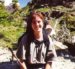 attention
was more focused on the mosquitoes and mayflies hovering just above the
water in a wild circus of aerial acrobatics. The silence of the wilderness
is enchanting. It speaks to you, way down deep. Thoreau said most men live
lives of quiet desperation, but here is where you can escape.
attention
was more focused on the mosquitoes and mayflies hovering just above the
water in a wild circus of aerial acrobatics. The silence of the wilderness
is enchanting. It speaks to you, way down deep. Thoreau said most men live
lives of quiet desperation, but here is where you can escape.
Andra finished her book, and began reading mine,
which was fine since I was more interested in skipping rocks across the
water. I honed a new rock-skipping technique that is just diabolical. It's
all in the wrist, man. My rocks didn't just skip, they skiied on the water.
I took a walk around to the bear-hole in the snowfield on the south shore
and found I couldn't get to it without swimming. I also found out that
this little bear hole was large enough to drive a Honda through. Didn't
look that big from the other side. Amazing what a 1000' wall does to perspective.
We cooked dinner as the sun receded behind the
ridge to the west, and engaged in small talk with the unprepared hikers.
It was at this point that Steven rolled into camp. I was thinking he had
mentioned Cobalt as his next stop, but assumed that since he didn't make
it within 3 hours of us getting there I had misunderstood. I suppose he
just takes his time. He joined us in the kitchen and boiled some pasta
just like us. After dinner, Andra and I sat by the lake until after sunset,
then buried ourselves in warm sleeping bag goodness for the night.
I slept horribly that night. Thoughts of returning
to civilization or an unfortunately placed rock? Who knows. But it was
an endless night of restless dozing, and I was glad to see the tent lighting
up that morning. We had very little distance to cover that day, so we took
it pretty easy and slow. The other folks got up and out long before we
even packed up our tent. We sat by the lake for a bit and ate a leisurely
breakfast of pancakes before packing up and heading down.
 We
stopped for a few minutes by Rockwell Falls on the way, but the call of
fresh sheets and a shower beckoned us down. I always find it strange how
when I'm in the woods, I want civilization things, and when I'm in "civilization",
I want backwoods things. I just can't shake my fickle human nature. We
last saw Steven sitting just beyond Rockwell Falls boiling water for tea.
How can you not like a guy of few words backpacking solo in the forest
and boiling water for tea by a waterfall? We plodded along at a good clip,
and as the day grew warmer, I began to have pain in my hips where the pack
rested. By the time we hit the parking lot, I was carrying my pack on my
shoulders only. My pack fits great, but five days is five days. I was happy
to take it off.
We
stopped for a few minutes by Rockwell Falls on the way, but the call of
fresh sheets and a shower beckoned us down. I always find it strange how
when I'm in the woods, I want civilization things, and when I'm in "civilization",
I want backwoods things. I just can't shake my fickle human nature. We
last saw Steven sitting just beyond Rockwell Falls boiling water for tea.
How can you not like a guy of few words backpacking solo in the forest
and boiling water for tea by a waterfall? We plodded along at a good clip,
and as the day grew warmer, I began to have pain in my hips where the pack
rested. By the time we hit the parking lot, I was carrying my pack on my
shoulders only. My pack fits great, but five days is five days. I was happy
to take it off.
I marched into the general store and purchased
two cans of Coca Cola, and after washing down in the restroom (man, how
the dirt did fly!) we sat under a tree on the beach of Two Medicine and
had a picnic. From the beach we could still see Two Medicine Pass, cloudy,
in the distance.
*****
The
remainder of the trip held much less adventure than the first. We sat in
the car that took us 30 miles north to Many Glacier Valley, only 30 miles
from Canadian soil. Our motel room was one of about 8 in a small building
in a compound of buildings cleverly spaced so as to seem almost cabin-like.
I enjoyed the room. No TV, no AC, no phone, no digital alarm clock. Perfect.
I happened to read in the welcome card that renovation was planned for
the entire motel to make it more modern. That's just what this motel needs,
absolutely. Someone is really using his head. Is it unusual that I am hard
pressed to find an example of something that mankind cannot make worse?
But I digress. We spent one evening in the motel room. Dinner was had at
the Italian Ristorante adjoining the motel lobby. The food was very nice,
and I enjoyed our window table for two, from which I could examine the
herds of tourists crowding around a telescope to see a mountain goat. It
is here that I learned definitively, from a college waitress from Washington
U, the real identity of huckleberries and thimbleberries (prior to that,
they were just good berries along the trail, discerned in conversation
only as "red" or "purple").
Our last morning at the park was spent tromping
the well-worn paths to the south of Many Glacier Hotel, a Stratford-style
monument to 19th century opulence. The trails led to sites of interest
very quickly, and we dutifully photographed every lake and waterfall we
passed. The valley air hung like a cloth from all the smoke overhead, and
the sun filtered through in a reddish haze, if at all. Perhaps the sun
would not have seemed so dim had I more than an hour or two left in the
park. We headed back to the Italian Ristorante and had a pizza for lunch
before heading east out of the park, bound for southern skies.
*****
Imagery from
this trip location is available for sale in the Montana album at LandscapeImagery.com