July 8, 2006
Anytime Dave visits from Hawaii, we try
to work in a nice forest hike in the mountains. When he visited in early
July 2006, we naturally planned an ambitious trek up to the summit of Mt
Audubon, one of seven 13,000 ft peaks in the Indian Peaks Wilderness outside
of Boulder. He was staying in Denver and we could come down from Cheyenne
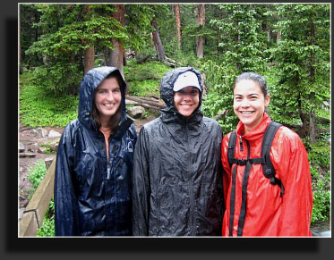
and meet in Boulder, then pool up to the parking lot and hike. His girlfriend,
Malia, and her sister, Eily, planned to come along and Andra decided to
come down with me. Great. All set. What could be better than a beautiful,
sunny July morning hiking in the wilderness? Well, the forecast of all-day
rain for once wasnt wrong, and we surveyed the steel-grey sky through
the windows of Moes Bagels in Boulder. An unseasonably cool spell had
set in over Colorado for over a week, and consisted of cool, cloudy mornings
with rainy afternoons and evenings. This was not at all what one thinks
of for July in Colorado, unless youve been staying in Seattle for too
long.
We drove two cars north of town, and then
cut west up Left Hand Canyon. It began to rain in the canyon, slicking
the road and providing, Im guessing, miserable conditions for the numerous
cyclists huffing and puffing their way up to Ward. I felt all the more
cozy in my heated and dry car. I kept thinking, "Im going to go hiking
in this crap?" We reached the lovely town of Ward in 25 minutes, a tiny
shanty town off Highway 72 where the speed limit is 15 mph and dirt roads
outnumber paved roads about 4 to 1, there being 1 paved road in town and
4 dirt roads. Just past Ward, we jogged a little to the north and resumed
our westward voyage through increasing rain on Brainard Lake Road. We literally
drove in the clouds. Ragged waifs of cloud slipped quickly overhead, alternately
revealing and hiding dark conifers. At a fee booth we paid our $7/car payment
to enter the Brainard Lake Recreation Area, which as far as I can tell
means that they have RV spots and flush toilets. Glad I can subsidize that
with my hiking fee. We resumed uphill, to the Mitchell Lake trailhead,
which is just past Brainard Lake at the end of the road. While we had originally
planned on trying Mt Audubon, the rain convinced us that the gentler, lower-elevation
route to Blue Lake was a better choice. Both trails leave from the same
spot, so we delayed a decision as long as possible.
Malia and Dave had brought no raingear,
but we had a spare jacket for Malia. Dave threw on a couple of layers of
t-shirts and was good to go. I threw on my rain jacket, as did Andra. After
several recent days of hiking in the rain, I was getting accustomed to
my noisy, plastic shell. The rain came down steadily, but lightly, and
I was impressed with how many cars were nevertheless in the parking lot.
I was also impressed that not only was the parking lot paved
the roads
to it had curbs. I cant recall being to a trailhead parking lot with curbs.
This was clearly upscale. The Indian Peaks Wilderness, at roughly 77,000
acres, was established in 1978 and is one of the busiest wilderness areas
in the US, being so close to Boulder, Denver metro, Loveland, Longmont,
etc. The number of cars, and for that matter, the size of the paved parking
lot, reinforced the high-use status of the area. We encountered lots of
folks milling about, zipping up raingear and gaiters, some taking refuge
in the shelter of the privy overhang. I looked for the hot dog cart, but
apparently had just missed his round.
We got going up the trail around 9:00,
Andra in front, then Eily, Malia, myself, and Dave. Rain pattered down
on my hood and the bill of my ball cap, making conversation difficult.
Nevertheless, we chatted back and forth about a variety of topics, tromping
along the muddy, puddle-strewn trail on a slight grade. The trail was more
water than soil, and I was thankful for my water-resistent boots that allowed
me to splash through puddles and deep mud without thinking twice. Viva
la GoreTex! Not so for our friends in sneakers, which got soaked quickly
despite valiant efforts at walking on exposed rocks and high points in
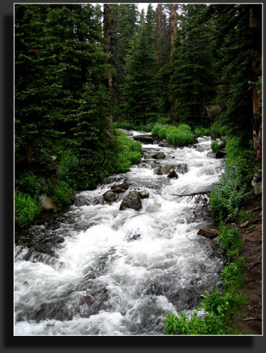
the trail. We crossed over a wide and shallow stream that coursed through
jagged rocks and little islands of mountain bluebells, globeflower and
northern paintbrush. Very beautiful. Every plant was covered in large drops
of water, fed by the fine drizzle that fell perpetually.
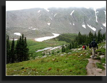
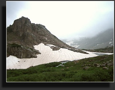
By degrees, we began to see the rocky slopes
up ahead. Steep, scree-covered inclines, still masked with snow, revealed
their jagged crowns through the mist. The trail led by Mitchell Lake at
about mile 1, a shallow bowl just at timberline, and led on west, climbing
very slightly. I read that 50 lakes preside in the Indian Peaks Wilderness,
but I believe that only accounts for the officially named lakes, since
we passed by about 10 lakes/ponds/tarns on this hike, whereas only 2 had
names. I appreciated the gentle slope, since a big incline would make me
sweat. Sweating heavily inside a plastic rainjacket leads to a miserable
day, like being slow-roasted. Often when hiking you either get soaked from
rain, or throw on a rainjacket and get soaked with sweat. I havent quite
decided which is worse. Theres just no way to get around getting wet when
its raining and yourre hiking. My feet were still dry, however, and for
that I was pleased. Viva la GoreTex!
The trail led us above timberline, with
awesome views of the surrounding peaks: Little Pawnee Peak, Paiute Peak
(there were once lots of Indians here, hence, Indian Peaks Wilderness)
and Mt Toll and Mt Audubon (there were also white men). Bunches of columbines,
their purple sepals gleaming in the filtered white light, dotted the alpine
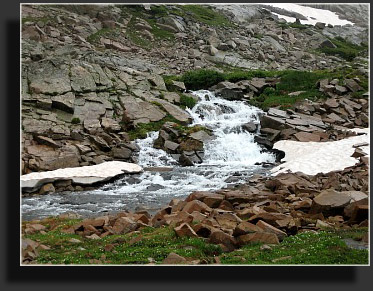
tundra beside the trail. Rushing water was everywhere, and for long stretches
it flowed down the trail like it was a streambed. Giant snowbanks persisted
all around, with water sluicing out from under them, rippling on the rocks
and gravel with magnificent, soothing foaming action. I imagine this would
be both a beautiful and crowded place to backpack. I met some folks while
camping in Rocky Mountain (just to the north) who had made reservations
to backpack in Indian Peaks. That was the first time Id ever heard of
needing reservations to camp in National Forest Service Wilderness. Yet
the traffic is understandable, given the beauty, proximity to urban hubs
and easy-access to alpine environments offered by the Indian Peaks. Plus
the curbs on the roads, that really draws them in.
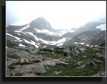
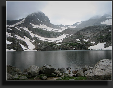
In what seemed like less than the advertised
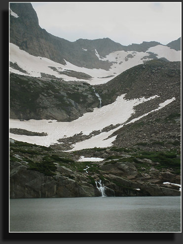
3-miles (or else Im just in fabulous physical shape), we reached Blue
Lake, one of the prettiest alpine lakes Ive had the pleasure of seeing
first-hand. Calendars make me suspect that Canada has some better ones,
but Im not convinced yet. It was large, and deep, situated around 11,320
at the base of Paiute Peak and Mt Toll. Large snowfields of irregular shape
clung to the scree slopes opposite us, and a waterfall crashed down the
steep slope and fell straight into the lake. Im not sure if this was a
phenomenon brought on by the rain or not, but it was spectacular. Tiny
hikers crossed a snowfield high above, and we felt absolutely no desire
to join them. The tops of the surrounding peaks were visible for moments
at a time before they would again be cloaked in cloud. Blue Lake is a name
given to a lake when you just cant think of anything else, I feel. There
are dozens of Blue Lakes in Colorado alone. Theres one in Kiowa County
where record bass are fished, but most are alpine, such as the one in Mt
Sneffels Wilderness, or the one near Breckenridge, or in Rocky Mountain
National Park, or in Mesa County, or outside of Canon City, or near the
city of Blue Lake, Colorado, or my personal favorite, Blue Lake in the
Rawah Wilderness. I can just picture some early USGS team at the end of
the day pondering what to name a lake, and giving up on a quirky, clever
name and saying, "Ah, heck, its blue aint it? Blue Lake it is." The rain
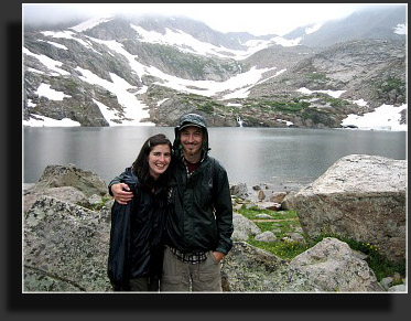
was very light by that point, but the wind picked up and chilled us all.
Even insanely-high-calorie snacks didnt shake the chill. We stood by the
lakeside getting goosebumps, took a few photos, ate some snacks, and then
headed back down. It had taken us just under 2 hours to reach the lake.
The hike down went quickly, as one would
expect, and we did receive a 10-20 minute respite from the rain where I
pulled my hood off and heard the birds singing in the meadows. However,
even when it stops raining in the woods, the trees continue to throw down
water from needle tips for another 30 minutes, so it is very hard to tell
if and when it actually stops raining. Again, I was impressed by the number
of people on the trail in the rain. Many were not wearing rain jackets.
Not me. I bought my rainjacket for a trip to the Pacific Northwest but
ended up never using it. I sure got a lot of use out of it in July 2006.
I slipped once on rocks, bruised my hand, and spent a good portion of the
remainder of the hike dreaming up ways to make Vibram soles grip better
in rain. Sand-impregnated rubber? Screw-in studs like track cleats? The
problem must have a multi-million dollar solution.
We made it back to the parking lot in about
an hour, and changed quickly into drier clothes. My undershirt was still
dry, as were my socks. Viva la GoreTex! We drove back down over rain-glazed
pavement to Boulder for a tasty lunch at Qdoba. |
Photos
by Dave Burns. I was too whimpy to take my camera out in the rain.
|
;)
;)
;)
;)
;)
;)
;)