-
-
BLUE LAKE
-
-
Location: Rawah Wilderness, northern Colorado
-
Maps: USGS Quad 1:24K Clark
Peak :, Trails Illustrated 1:40K
Cameron Pass #112
-
Access: Hwy 14 west 53 miles from Ted's Place to the Blue Lake trailhead
on the north side of the road.
-
Trailhead: NAD83 zone 13 427584e 4492445n Elev: 9450'
-
Trail: 7 miles one way. 1300 ft elevation gain. Begins in forest,
several bridged stream crossings, ends in alpine tundra.
-
Fees: None
-
Dog Regulations: Voice control in National Forest (1st 1.5 miles),
leash control in wilderness.
-
Weather: Current
and recent conditions Local
Forecast
-
-
November 12, 1999
-
Despite
failing to actually reach the destination on two previous attempts, once
due to bad weather and another due to a 3:00 ecology class that cut the
trip short, I was trying once again to grunt my way up to Blue Lake on
the west side of Cameron Peak, the namesake of the popular highway pass
in northern Colorado. The route drawn out on my USGS map looked like 5
miles, the Colorado Ski Patrol map estimates 7. Either way, the trail is
not terribly long, but the terrain is not flat. The countless rolls and
slants that the trail winds over make it much more difficult than one thinks
when looking at the map. The hills strain the legs, and the ever-present
snow dulls one's step. Even so, I determined to make Blue Lake regardless
of obstacles or weather, and I planned the day accordingly.
-
-
I was up at 6, just before a beautiful November dawn. I sat
behind the steering wheel of my girlfriend's Toyota Corolla (borrowed for
this occasion) and was on the road out of town, into reality, by 7 AM.
The front seat was loaded with a bag full of food, water, warm clothes
and my camera, while the back seat was loaded with my faithful canine adventure
companion, Frankie, ever eager to wander on pointless discourses over hostile
terrain with me. Without traffic on Highway 14 up along the Poudre River,
I made it to the trailhead in 1.5 hours. There are few things more frustrating
than planning an outdoor excursion, getting up early and driving away from
the smog of the city only to be held captive in your car by inclement weather.
It has happened to me on occasion, but fortune smiled on me as I stepped
out of the car into a dreamlike day. The sun was low on the horizon, casting
a friendly warm glow in the morning mist of the pine forest which surrounded
me. The sky was without clouds, and though cheery clouds on occasion will
add to the enjoyment of a day's hike, in the mountains it is usually more
comforting for clouds to be absent, for if they be friendly one hour, they
will be angry the next. It was unusually warm for November in Colorado
at 10,000 ft, and the snow was conspicuously absent. A bit of a breeze
moaned through the pines, but it was mild. The lot was empty as I shouldered
my pack, and I looked forward to a solitary trail.
-
-
-
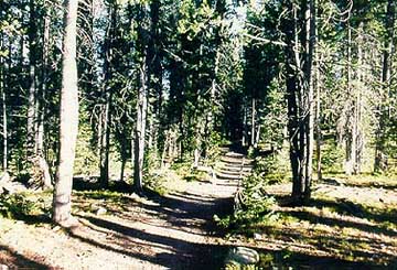
The first bit of trail led through a very deep growth of
lodgepole pine and subalpine fir, casting a cool darkness that belied the
brilliant sunshine outside the dense evergreen canopy. The ground was carpeted
with bryophytes, resembling, at a perfunctory glance, well-groomed turf.
Before I had gone 200 yards, I had to stop to pull off my down vest, gloves
and cotton flannel. It is always difficult for me to correctly guess a
comfortable layering of clothing while hiking. The body heats up rapidly
while strutting over rough terrain, such that one is often comfortable
in a t-shirt at 40F, as long as movement is sustained. Cessation
of movement invariably invokes an instant chill. The sunlight and
wind both wreak havoc on comfort-levels, having opposite effects but both
appearing and disappearing as one enters valleys, rounds corners or encounters
dense forest. Thus, maintaining comfortable body temperature is a
challenge in itself.
-
-
A bridge crosses Sawmill Creek, a stretch of water that flows
rapid in the confines of a small groove sliced out of the forest soil.
It is nice, fresh and vibrant. If I wasn't so terrified of Giardia,
I might give in and venture a drink straight from it. Beyond the bridge
the trail widens and appears to be well maintained, that is, free of ruts,
trees, rocks, etc. Frank enjoyed himself immensely from what I could
observe; constantly hunting the unseen chirps and chatters in the underbrush
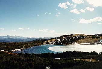
beyond. At about 1.5 miles, we reached a sharp bend in the trail
that overlooked Chambers Lake, a deep blue bowl larger than just about
every lake in the region. We stopped only for a moment, for I had
gazed at this sight before. I was after the next thrill.
-
-
I hiked at a fast pace, about 3 mph I figure, and felt great.
Distant rumblings in my belly warned of the need for an early lunch.
Nothing makes me hungrier than hiking. I ignored it. Mind over matter,
and belly. Lunch should come at the halfway mark of the trip and
not before. Soon we came to another bridge, not nearly as well-kept
but quite functional. The stream it spanned, Fall Creek, was much
smaller than the first, yet not less inviting. Immediately on the
other side of this stream lay the imaginary demarcation delineating "normal"
forest from "wilderness" forest, a distinction whose only implication is
that you can no longer build a gas station or ride motorbikes along the
trails. To George Bush, there apparantly is NO distinction at all.
The trail likewise becomes narrow and less "groomed"; consequently my approval
increased.
-
-
It is through this section of the trail that I got tired.
The path led up steep, long slopes that made my calves burn and ache, then
led down steep, long slopes that fatigued my quads and jammed my toes.
At 9:30 we made our first stop of the trip on an upward slope in the shade.
I sat on a conveniently located log and ate some peanuts, throwing Frank
a nut or two to keep him happy. Amazingly, he always enjoys whatever I'm
eating. Ten minutes later we were off again, up and down on the trail.
-
-
The sun rose higher in the sky so that it consistently lit
the path before me in flecks and streaks of brilliant white. The sun felt
good, and warmed me in the chilly breeze. I knew by then that the wind
I was feeling gently flitting by would be a gale on the open alpine shores
ahead. I could hear distant whistles of gusts through the tree tops.
-
-
A third bridge came up on the trail, this one spanning an
even smaller and shallower trickle than before. This too was Fall Creek,
but in its infant form. In fact, the bridge is quite superfluous, as any
reasonably fit person could manage to leap over it. While I utilized
the luxury of the bridge, Frank rebuked, and splashed noisily through the
icy water. (Although he took the bridge on the way back) I halted
briefly among the moss-shrouded firs to consult my map. I had reached the
point of my turn-back the year before, where I had met two men who told
me (and lied) that the lake was still 4 or 5 miles away. I had since
doubted that assertion, and the map told no lies. I was close, and getting
anxious. By now my hunger had waxed voracious, and I was eager to devour
my lunch on the shore of the advertised attraction. Confident that my destination
was imminent, I continued on.
-
-
Here and there Frank would halt abruptly, dashingly handsome
in his rigid regal point to the quarry. A positive word from me and he
would tear off like a greyhound, only to have his would-be lunch scurry
up the tree and chatter angrily at him from it safe perch high above. On
rare occasions I've watched Frank, in a fit of blood lust, scale the trunk
of a tree 10 ft or more before his momentum gave out and his claws slipped.
To date, he has recorded 0 kills.
-
-
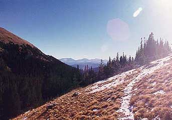
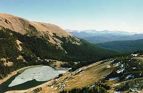
The landscape changed rapidly as I plodded quietly along.
Dense lush forest gave way to open brown tundra. A small wooden sign forbade
camping within 1/4 mile of the lake. I walked 300 yards further and there,
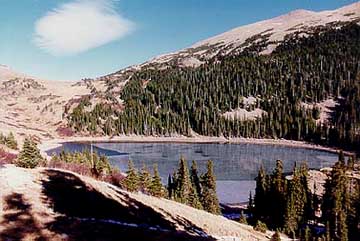
to my right, was a giant glacier-carved bowl filled with water. The time
was 10:35. It was indeed Blue, but only on the edges that yet were free
from the smooth expanse of silver ice that lay on the surface, crisscrossed
with white cracks resembling a spider's web. The shoreline was rocky, and
the trees were few (being alpine tundra). The predominant feature of the
area was scrubby brown grass, and the wind howled under the white sun.
-
-
The trail didn't seem to go down to the lake shore, which
was several hundred feet down a loose slope, but instead threaded around
and over a distant ridge, onward to Tunnel Creek Campground 6 miles away.
Given the bleakness of the surrounding terrain, I decided to venture a
climb up the imposing slope on the west, 320 feet, to Hang Lake, Blue Lake's
little brother. Hang Lake is not visible from the trail, and no trail at
all was apparent to this destination. The only indications I had of the
presence of any body of water was the map, and two ravines filled with
ice cutting the slope toward me. One, or both, lead to the lake. I wasn't
sure which ravine to take, so I guessed and took the wrong one.
-
-
The going was hard to begin with. I was over 11,000 ft by
then, and my leg muscles were tight from the fast-paced 6 miles they'd
just reeled off. In addition, the slope kept getting steeper and steeper,
and while Frank the Wonder Dog trotted up with typical dog ease, I found
myself stopping every 10 steps to sit down and pant. I planned my ascent
to the obvious ridge up above in 8 thirty-foot intervals. Each time I achieved
a landmark, I rested. I realized too late how poorly my route choice had
been. The slope I was on became absurdly steep, and wholly consistent of
loose rocks and gravel. Every step I took caused me to slide back one,
yet I couldn't bear the thought of turning around at that point. Great
maneuvering was required to edge myself to the left, on all fours but almost
erect, to a stretch of solid earth anchored by dwarfed timberline firs.
It was on my way over that I lost my lens cap. It tapped a rock and bounced
free. I watched unsympathetically as it bounced and slid 50 or 60 feet
down. It finally disappeared under the loose rocks, destined to be buried
for the next 12 millennia. Civilized ants will one day ponder the meaning
of NIKON.
-
-
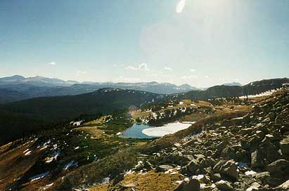
By the time I reached solid footing, all strength had deserted
me, apparently going directly to Frank, and my muscles quivered with fatigue.
Ruefully, I looked to the south and saw Hang Lake shimmering some 50 feet
lower and 300 feet to the south of my current precarious perch. Dangit.
Couldn't be helped. I had targeted the ridge above me, and I was going
there, by gosh. I pressed on 10 steps, rest, 20 steps, rest, 30 steps,
big rest, 40 steps, and I was there. I reached a small area of flat ground
on the edge of a giant boulder field that sloped gently up towards a spire
that stabbed another hundred feet towards the sky. This was Clark's Peak.
-
-
I immediatly broke out my lunch and ate. In matters of etiquette
I am reasonably refined, but something animalistic came over me on top
of that ridge. I tore into my food without thought for taste or even
chewing. The cold, the wind, the long hike, the aching muscles; all contributed
to an eating style wholly unacceptable within city limits. I ate voraciously.
My hands were heavy and unresponsive from the cold and rough treatment
up the loose rocky slope, but they managed to shovel in food all the same.
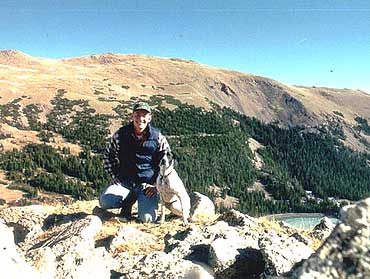
I began to enjoy the mistake I had made as I commanded a magnificent view
of both lakes below me. Cameron Peak, opposite Blue Lake, rose up even
higher, a slumbering hulk of raw rock with, oddly enough, absolutely no
snow to grace its cap in November.
-
-
After eating all available food and throwing Frank some peanut
shells to abate his begging, I pulled out the camera and loaded new film.
I also donned my previously-shed warm clothes to combat the wind. I took
a few photos of Frank and I and the surrounding area before finding a reasonably
sheltered crook in the rocks to relax. Turned out to be only partially
shielded, for I soon took note that the wind blew alternately from two
opposite directions. Periods of calm interluded the raging wind, and in
those times I could've napped for hours. I tried, but the bite of the wind
prompted me to keep moving.
-
-
The clouds began to move across the sky in ever-increasing
numbers. They sailed along with the same apparent speed and mechanical
precision of a locomotive. It always amazes me how fast clouds move to
the terrestrial observer at 12,000 ft. At that elevation, the clouds often
pass by below you. When they blocked out the sun it became cold, instantly,
but rarely did this last for more than 10 seconds before they were out
of the way. Although the clouds were puffy and white, I was wary of what
lay behind the wall of rock to the west.
-
-
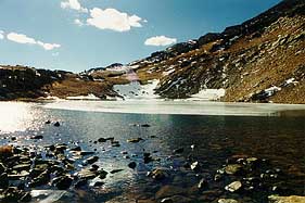
I made my way toward Hang Lake by scrambling over sideways
and crossing the aforementioned ravine. I encountered thick, knotted growth
of elevation-stunted fir. This peculiar growth pattern results from the
fact that the ground freezes solid in the winter and the plants have no
access to water. For the most part they are buried beneath snow which
blocks out light, inhibiting photosynthesis, thus inhibiting respiration
and subsequent water loss to evapotranspiration. However, if any part of
the plant protrudes above snow line, it will photosynthesize, respire,
and lose water which it cannot replace, whereupon it will dessicate, and
die. This growth pattern results in a plant architecture known as Krumholtz,
after the botanist who first described it. Thus is the stunted growth maintained,
and a century-old tree may be but 5 feet tall. Absolutely impenetrable
when taller than 4 feet, Frank and I picked our way through the maze of
Krumholtz, drawing closer to the lake most of the time. As we neared the
shore, an especially sharp wind howl prompted me, reflexively, to look
up out onto the lake whereupon I saw something I'd never seen before. A
tight whirlwind had sucked water up in a vortex 70 ft high to create a
fleeting tube of white mist. I pulled up my camera to capture the mountain
waterspout, but by the time I had the shutter speed set, the show was over.
I waited around for the encore performance, but it did not air.
-
-
The water in the lake was crystal clear, true to mountain
lake form, and we strolled along the shore towards the outlet, and the
formerly passed over ravine down to Blue Lake. I snapped a few photos
and plunged through the Krumholtz to the ravine, my easy ticket back down.
For all the work invested getting up, I made it down in less than 15 minutes.
-
-
As I began backtracking into the sheltered forest, I removed
clothing as the wind was diminished.
-
The way back was more downhill, but because of my tired legs
and a raging headache, took me 45 minutes longer to complete. I stopped
a few times, at one point endeavoring a nap to rid myself of the throbbing
headache, but the sunlight waned and it grew cold enough to induce continued
movement. We got back to the car, and completed the hike, at 2:45.
Thus was the destination of Blue Lake checked off my list.
-
-
-
-
-
-
HOME
Back To Camping
NEXT
-
-
Page Created December 16,
1999
-
Updated January 3, 2003